Pingré (crater)
|
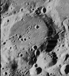
Lunar Orbiter 4 image | |
| Coordinates | 58°42′S 73°42′W / 58.7°S 73.7°WCoordinates: 58°42′S 73°42′W / 58.7°S 73.7°W |
|---|---|
| Diameter | 89 km |
| Depth | 2.3 km |
| Colongitude | 76° at sunrise |
| Eponym | Alexandre G. Pingré |

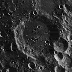
Pingré is a lunar impact crater that is located near the southwest limb of the Moon, beyond the large crater Phocylides. It lies to the northwest of the huge walled basin Bailly, and to the east of the smaller Graff. Due to its location, this crater appears foreshortened when viewed from the Earth.
The outer rim of this crater has become worn due to minor impacts, leaving the features rounged and irregular. The wall is nearly disintegrated in the southeast, and is overlain by a small crater along the eastern rim. The rim is also low and slumped to the northwest. The interior floor is relatively level, but marked by several small craters, which may be secondaries from Hausen or a more distal crater. These craters occur near the midpoint of the floor where a central peak may once have existed.
Pingré lies to the southeast of the Mendel-Rydberg Basin, a 630 km wide impact basin of Nectarian age.
Satellite craters
By convention these features are identified on lunar maps by placing the letter on the side of the crater midpoint that is closest to Pingré.
| Pingré | Latitude | Longitude | Diameter |
|---|---|---|---|
| B | 57.6° S | 65.3° W | 19 km |
| C | 58.4° S | 68.3° W | 23 km |
| D | 56.6° S | 84.1° W | 16 km |
| E | 56.5° S | 78.9° W | 14 km |
| F | 59.9° S | 71.0° W | 16 km |
| G | 57.9° S | 68.9° W | 13 km |
| J | 59.1° S | 68.8° W | 18 km |
| K | 55.2° S | 77.7° W | 13 km |
| L | 53.8° S | 85.8° W | 17 km |
| M | 53.5° S | 83.6° W | 19 km |
| N | 58.1° S | 83.7° W | 19 km |
| P | 54.0° S | 69.5° W | 16 km |
| S | 60.3° S | 82.0° W | 70 km |
| U | 56.3° S | 66.0° W | 12 km |
| W | 56.4° S | 70.9° W | 9 km |
| X | 58.9° S | 79.3° W | 9 km |
| Y | 58.4° S | 78.0° W | 13 km |
| Z | 55.1° S | 82.7° W | 12 km |
The following craters have been renamed by the IAU.
- Pingré H — See Yakovkin.
References
- Andersson, L. E.; Whitaker, E. A. (1982). NASA Catalogue of Lunar Nomenclature. NASA RP-1097.
- Blue, Jennifer (July 25, 2007). "Gazetteer of Planetary Nomenclature". USGS. Retrieved 2007-08-05.
- Bussey, B.; Spudis, P. (2004). The Clementine Atlas of the Moon. New York: Cambridge University Press. ISBN 978-0-521-81528-4.
- Cocks, Elijah E.; Cocks, Josiah C. (1995). Who's Who on the Moon: A Biographical Dictionary of Lunar Nomenclature. Tudor Publishers. ISBN 978-0-936389-27-1.
- McDowell, Jonathan (July 15, 2007). "Lunar Nomenclature". Jonathan's Space Report. Retrieved 2007-10-24.
- Menzel, D. H.; Minnaert, M.; Levin, B.; Dollfus, A.; Bell, B. (1971). "Report on Lunar Nomenclature by the Working Group of Commission 17 of the IAU". Space Science Reviews. 12 (2): 136–186. Bibcode:1971SSRv...12..136M. doi:10.1007/BF00171763.
- Moore, Patrick (2001). On the Moon. Sterling Publishing Co. ISBN 978-0-304-35469-6.
- Price, Fred W. (1988). The Moon Observer's Handbook. Cambridge University Press. ISBN 978-0-521-33500-3.
- Rükl, Antonín (1990). Atlas of the Moon. Kalmbach Books. ISBN 978-0-913135-17-4.
- Webb, Rev. T. W. (1962). Celestial Objects for Common Telescopes (6th revised ed.). Dover. ISBN 978-0-486-20917-3.
- Whitaker, Ewen A. (1999). Mapping and Naming the Moon. Cambridge University Press. ISBN 978-0-521-62248-6.
- Wlasuk, Peter T. (2000). Observing the Moon. Springer. ISBN 978-1-85233-193-1.
