Pico da Antónia
| Pico da Antónia | |
|---|---|
|
View over Pico da Antónia | |
| Highest point | |
| Elevation | 1,394 m (4,573 ft) |
| Listing | List of mountains in Cape Verde |
| Coordinates | 15°03′4″N 23°38′7″W / 15.05111°N 23.63528°WCoordinates: 15°03′4″N 23°38′7″W / 15.05111°N 23.63528°W |
| Geography | |
 Pico da Antónia central Santiago | |
| Geology | |
| Mountain type | Stratovolcano |
| Climbing | |
| Easiest route | climb |
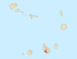
Pico da Antónia is Santiago's tallest mountain located in the central part of the island in Cape Verde. The mountain is part of the protected area Parque Natural de Rui Vaz e Serra de Pico de Antónia which includes other features as the Órgãos and Montes Tchota and Xexê.[1] The mountain is entirely of volcanic origin. The towns Picos and Assomada lie close to the mountain. The area around the peak has been identified by BirdLife International as an Important Bird Area.[2]
The mountain range forms a part of the municipalities of São Salvador do Mundo, São Lourenço dos Órgãos and Ribeira Grande de Santiago.
North of the summit is a stream named after peak, the Ribeira de Pico da Antónia, next to the settlement of Pico da Antónia and the Praia-Assomada-Tarrafal Route (EN1-ST01), it flows into the ocean as Ribeira Seca.
Geology
Its geology consists of the Pico da Antónia formation consisting of calcarenothorizonite rocks, it was formed between 3.3 to 2.3 million years ago during the Piacenzian and the Gelasian periods.[3]
History
During the Ice Age from 15000 to 10000 BC, the elevation was above 1,500 meters, around 5000 BC, it mounted above 1,400 meters.
Along with the island, the peak was first sighted by explorer António da Noli in 1460 and is considered the first land mass known to the world map of the Europeans.The area to the east of the range was first settled sometime around the start of the 16th century when settlers and mostly slaves started to pour into the area. At the time, the peak area were forested with trees and shrubs, around the 17th century, most of the east of the area were mainly deforested. The peak were depicted in several pictures that were viewed from Praia and paintings especially of the 18th, 19th and early 20th centuries. At the start of the 21st century, most of the east of the area have been reforested.
Panoramics
It is the place on the island where panoramics are offered including many parts of the island other than many areas north of Serra da Malagueta. In the uppermost areas, the views of nearby islands can be seen including Maio to the east, Fogo to the west and rarely Boa Vista to the northeast.
References
- ↑ Protected areas
- ↑ "Serra do Pico da Antónia". Important Bird Areas factsheet. BirdLife International. 2013. Retrieved 2013-08-16.
- ↑ Holm, P. M. (2008). An 40Ar-39Ar study of the Cape Verde hot spot: temporal evolution in a semistationary plate environment. 113. J. Geophys. Res. p. B08201.
Further reading
- Ricardo A. S. Ramalho, "The Pico da Antónia Volcanic Complex", in Building the Cape Verde Islands, Springer, 2011, p. 106-110 ISBN 9783642191022
.jpg)


