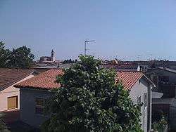
Piadena
| Piadena | ||
|---|---|---|
| Comune | ||
| Comune di Piadena | ||
 | ||
| ||
 Piadena Location of Piadena in Italy | ||
| Coordinates: 45°8′N 10°22′E / 45.133°N 10.367°E | ||
| Country | Italy | |
| Region | Lombardy | |
| Province / Metropolitan city | Cremona (CR) | |
| Frazioni | Vho, S.Lorenzo Guazzone, S.Paolo Ripa Oglio | |
| Government | ||
| • Mayor | Bruno Tosatto | |
| Area | ||
| • Total | 19 km2 (7 sq mi) | |
| Elevation | 34 m (112 ft) | |
| Population (30 November 2008) | ||
| • Total | 3,601 | |
| • Density | 190/km2 (490/sq mi) | |
| Demonym(s) | Piadenesi | |
| Time zone | CET (UTC+1) | |
| • Summer (DST) | CEST (UTC+2) | |
| Postal code | 26034 | |
| Dialing code | 0375 | |
| Patron saint | St. Pammachius | |
| Saint day | 30 August | |
| Website | Official website | |
Piadena is a comune in the Province of Cremona, Italy.
World heritage site
It is home to one or more prehistoric pile-dwelling (or stilt house) settlements that are part of the Prehistoric Pile dwellings around the Alps UNESCO World Heritage Site.[1]
References
External links
| Wikimedia Commons has media related to Piadena. |
This article is issued from
Wikipedia.
The text is licensed under Creative Commons - Attribution - Sharealike.
Additional terms may apply for the media files.
