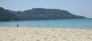
Phuket Province
| Phuket ภูเก็ต | ||
|---|---|---|
| Province | ||
| ||
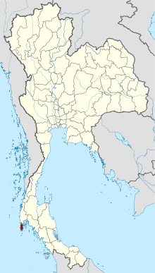 Map of Thailand highlighting Phuket Province | ||
| Country | Thailand | |
| Capital | Phuket City | |
| Government | ||
| • Governor | Noraphat Plotthong (since April 2017) | |
| Area | ||
| • Total | 576 km2 (222 sq mi) | |
| Area rank | Ranked 75th | |
| Population (2015) | ||
| • Total | 386,605 | |
| • Rank | Ranked 68th | |
| • Density | 1,042/km2 (2,700/sq mi) | |
| • Density rank | Ranked 6th | |
| Time zone | ICT (UTC+7) | |
| ISO 3166 code | TH-83 | |
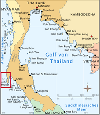
Phuket (Thai: ภูเก็ต, [pʰūː.kèt]) is one of the southern provinces (changwat) of Thailand. It consists of the island of Phuket, the country's largest island, and another 32 smaller islands off its coast.[1] It lies off the west coast of Thailand in the Andaman Sea. Phuket Island is connected by the Sarasin Bridge to Phang Nga Province to the north. The next nearest province is Krabi, to the east across Phang Nga Bay.
Phuket Province has an area of 576 square kilometres (222 sq mi), somewhat less than that of Singapore, and is the second-smallest province of Thailand. It formerly derived its wealth from tin and rubber, and enjoys a rich and colorful history. The island was on one of the major trading routes between India and China, and was frequently mentioned in foreign ship logs of Portuguese, French, Dutch, and English traders. The region now derives much of its income from tourism.
Name
There are several possible derivations of the relatively recent name "Phuket" (of which the digraph ph represents an aspirated p): It is either derived from the word bukit (Jawi: بوكيت) in Malay which means "hill", as this is what the island appears like from a distance.
Phuket was formerly known as Thalang (ถลาง Tha-Laang), derived from the old Malay "telong" (Jawi: تلوڠ) which means "cape". The northern district of the province, which was the location of the old capital, still uses this name. In Western sources and navigation charts, it was known as Jung Ceylon or Junkceylon (a corruption of the Malay Tanjung Salang, i.e., "Cape Salang"),[2]:179
Seal of Phuket
The seal is a depiction of the Two Heroines Monument along Highway 402 in Phuket. This commemorates sisters Thao Thep Kasattri and Thao Sri Sunthon who helped protect the province from Burmese invasion during the Ten Armies' Wars in 1785.[3] In 1785 Burmese troops were preparing to attack Phuket. Its military governor had just died, thus the Burmese thought the island could be easily seized. But Khun Jan, the widow of the deceased governor and her sister, Khun Mook, ordered the women of the island to dress as soldiers and take positions on the Thalang city walls. The Burmese called off their attack due to the perceived strength of the defenses. Short of food, they retreated. The two women became local heroines. They received the honorary titles, Thao Thep Kasatri and Thao Sri Sunthon, from King Rama I.[1]
The seal is a circle surrounded by a ka–nok line that shows the bravery of leaders in Phuket Province.[4] The seal has been used since 1985.
History
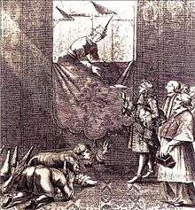
The Portuguese explorer Fernão Mendes Pinto arrived in Siam in the year 1545 (16th century). His accounts of the country go beyond Ayutthaya and included a reasonably detailed account of ports in the south of the Kingdom as well. Pinto was one of the first European explorers to mention Phuket in any detail, in his travel accounts. He referred to the island as ‘Junk Ceylon’, a name the Portuguese used for Phuket Island in their maps. Junk Ceylon is mentioned seven times in Mendes Pinto’s accounts. Pinto said that Junk Ceylon was a destination port where trading vessels made regular stops for supplies and provisions, however, during the mid-16th century, the island was in decline due to pirates and often rough and unpredictable seas, which deterred merchant vessels from visiting Junk Ceylon. Pinto mentioned several other notable port cities in his accounts, including Patani and Ligor, which is modern day Nakhon Si Thamarat.
In the 17th century, the Dutch, English and, after the 1680s, the French, competed for the opportunity to trade with the island of Phuket (then known as "Jung Ceylon"), which was a rich source of tin. In September 1680, a ship of the French East India Company visited Phuket and left with a full cargo of tin.
A year or two later, the Siamese King Narai, seeking to reduce Dutch and English influence, named as governor of Phuket a French medical missionary, Brother René Charbonneau, a member of the Siam mission of the Société des Missions Étrangères. Charbonneau remained as governor until 1685.[5]
In 1685, King Narai confirmed the French tin monopoly in Phuket to their ambassador, the Chevalier de Chaumont.[2]:179 Chaumont's former maître d'hôtel, Sieur de Billy, was named governor of the island.[2]:50 However, the French were expelled from Siam after the 1688 Siamese revolution. On 10 April 1689, Desfarges led an expedition to re-capture Phuket to restore French control in Siam.[6] His occupation of the island led to nothing, and Desfarges returned to Puducherry in January 1690.[2]:185
The Burmese attacked Phuket in 1785. Francis Light, a British East India Company captain passing by the island, notified the local administration that he had observed Burmese forces preparing to attack. Than Phu Ying Chan, the wife of the recently deceased governor, and her sister Mook (คุณมุก) assembled what local forces they could. After a month-long siege of the capital city, the Burmese were forced to retreat on 13 March 1785. The women became local heroines, receiving the royal titles Thao Thep Kasattri and Thao Si Sunthon from a grateful King Rama I. During the reign of King Chulalongkorn (Rama V), Phuket became the administrative center of the tin-producing southern provinces. In 1933 Monthon Phuket (มณฑลภูเก็ต) was dissolved and Phuket became a province.
2004 tsunami
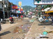
On 26 December 2004, Phuket and other nearby areas on Thailand's western coast suffered extensive damage when they were struck by the Boxing Day tsunami, caused by the 2004 Indian Ocean earthquake. The waves destroyed several highly populated areas in the region, killing up to 5,300 people nationwide, and tens of thousands more throughout the Asian region. Some 250 were reported dead in Phuket, including foreign tourists, and as many perhaps as a thousand of the illegal Burmese workers building new beach resorts in the Khao Lak area. Almost all of the major beaches on the west coast, especially Kamala, Patong, Karon, and Kata sustained major damage, with some damage caused to resorts and villages on the island's southern beaches.
By February 2005 many damaged resorts were back to business, and life slowly returned to normal. Following strenuous recovery programs, no tsunami damage can now be seen except on the most remote beaches.
In early December 2006, Thailand launched the first of the 22 U.S.-made tsunami-detection buoys to be positioned around the Indian Ocean as part of a regional warning system. The satellite-linked deep-sea buoys float 1,000 km (620 mi) offshore, roughly midway between Thailand and Sri Lanka.[7]
Geography
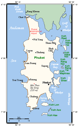 Map of Phuket (beaches in brown) | |
| Geography | |
|---|---|
| Location | Andaman Sea |
| Coordinates | 7°53′24″N 98°23′54″E / 7.89000°N 98.39833°E |
| Area | 576 km2 (222 sq mi) |
| Length | 50 km (31 mi) |
| Width | 20 km (12 mi) |
| Highest elevation | 529 m (1,736 ft) |
| Highest point | Khao Mai Thao Sip Song |
| Administration | |
|
Thailand | |
| Demographics | |
| Population | 386,605 (2015) |
| Pop. density | 1,042 /km2 (2,699 /sq mi) |
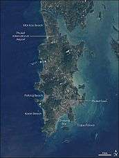
Phuket is the largest island in Thailand. It is in the Andaman Sea in southern Thailand. The island is mostly mountainous with a mountain range in the west of the island from the north to the south. The mountains of Phuket form the southern end of the Phuket mountain range, which ranges for 440 kilometres (270 mi) from the Kra Isthmus.
Although some recent geographical works refer to the sections of the Tenasserim Hills in the isthmus as the "Phuket Range", these names are not found in classical geographic sources. In addition, the name Phuket is relatively recent having previously been named Jung Ceylon and Thalang. The highest elevation of the island is usually regarded as Khao Mai Thao Sip Song (Twelve Canes), at 529 metres (1,736 ft) above sea level. However it has been reported by barometric pressure readings that there is an even higher elevation (with no apparent name), of 542 meters above sea level, in the Kamala hills behind Kathu waterfall.
Its population was 249,446 in 2000, rising to 525,709 in the 2010 decennial census,[8] the highest growth rate of all provinces nationwide at 7.4 percent annually. Some 600,000 people reside on Phuket currently,[9] among them migrants, international expats, Thais registered in other provinces, and locals. The registered population, however, includes only Thais who are registered in a "tabien baan" or house registration book, which most are not, and the end of 2012 was 360,905 persons.[10]
Phuket is approximately 863 kilometres (536 mi) south of Bangkok, and covers an area of 543 square kilometres (210 sq mi) excluding small islets. It is estimated that Phuket would have a total area of approximately 576 square kilometres (222 sq mi) if all its outlying islands were included. Other islands are: Ko Lone 4.77 square kilometres (1.84 sq mi), Ko Maprao 3.7 square kilometres (1.4 sq mi), Ko Naka Yai 2.08 square kilometres (0.80 sq mi), Ko Racha Noi 3.06 square kilometres (1.18 sq mi), Ko Racha Yai 4.5 square kilometres (1.7 sq mi), and the second biggest, Ko Sire 8.8 square kilometres (3.4 sq mi).
The island's length, from north to south, is 48 kilometres (30 mi) and its width is 21 kilometres (13 mi).[11]
Seventy percent of Phuket's area is covered with mountains which stretch from north to south. The remaining 30 percent are plains in the central and eastern parts of the island. It has a total of nine brooks and creeks, but does not have any major rivers.
Forest, rubber, and palm oil plantations cover 60 percent of the island. The west coast has several sandy beaches. The east coast beaches are more often muddy. Near the southernmost point is Laem Phromthep (Thai: แหลมพรหมเทพ)("Brahma's Cape"), a popular viewpoint. In the mountainous north of the island is the Khao Phra Thaeo No-Hunting Area, protecting more than 20 km² of rainforest. The three highest peaks of this reserve are the Khao Prathiu (384 metres (1,260 ft)), Khao Bang Pae 388 metres (1,273 ft), and Khao Phara 422 metres (1,385 ft). The Sirinat National Park on the northwest coast was established in 1981 to protect an area of 90 square kilometres (35 sq mi) (68 kilometres (42 mi) marine area), including the Nai Yang Beach where sea turtles lay their eggs.[12]
The most popular (and overcrowded) tourist area on Phuket is Patong Beach on the central west coast, perhaps owing to the easy access to its wide and long beach. Most of Phuket's nightlife and its shopping is in Patong, and the area has become increasingly developed. Patong means "the forest filled with banana leaves" in Thai. South of Patong lie Karon Beach, Kata Beach, Kata Noi Beach, and around the southern tip of the island, Nai Han Beach and Rawai. To the north of Patong are Kamala Beach, Surin Beach, and Bang Tao Beach. These areas are generally much less developed than Patong. To the southeast is Bon Island and to the south are several coral islands. The Similan Islands lie to the northwest, and the Phi Phi Islands which are part of Krabi Province, to the southeast.
Administrative divisions
Phuket is divided into three districts (amphoe), which are further subdivided into 17 sub-districts (tambon), and 103 villages (muban).
There are nine municipal (thesaban) areas within the province. The capital Phuket has city (thesaban nakhon) status. Patong and Kathu have town (thesaban mueang) status. There are further six sub-district municipalities (thesaban tambon)—Karon, Thep Krasattri, Choeng Thale, Ratsada, Rawai, and Wichit. The non-municipal areas are administered by nine tambon administrative organizations (TAO).
 Map of amphoe, the three districts of Phuket
Climate
Under the Köppen climate classification, Phuket features a tropical monsoon climate (Am). Due to its proximity to the equator, in the course of the year, there is little variation in temperatures. The city has an average annual high of 32 °C (90 °F) and an annual low of 25 °C (77 °F). Phuket has a dry season that runs from December through March and a wet season that covers the other eight months. However, like many cities that feature a tropical monsoon climate, Phuket sees some precipitation even during its dry season. Phuket averages roughly 2,200 millimetres (87 in) of rain.
| Climate data for Phuket (Mueang Phuket District) (1981–2010) | |||||||||||||
|---|---|---|---|---|---|---|---|---|---|---|---|---|---|
| Month | Jan | Feb | Mar | Apr | May | Jun | Jul | Aug | Sep | Oct | Nov | Dec | Year |
| Record high °C (°F) | 36.3 (97.3) |
36.7 (98.1) |
37.8 (100) |
37.8 (100) |
37.8 (100) |
35.8 (96.4) |
35.0 (95) |
35.5 (95.9) |
35.0 (95) |
35.3 (95.5) |
34.8 (94.6) |
34.2 (93.6) |
37.8 (100) |
| Average high °C (°F) | 32.7 (90.9) |
33.6 (92.5) |
34.0 (93.2) |
33.9 (93) |
32.8 (91) |
32.4 (90.3) |
32.0 (89.6) |
32.0 (89.6) |
31.5 (88.7) |
31.5 (88.7) |
31.7 (89.1) |
31.7 (89.1) |
32.5 (90.5) |
| Daily mean °C (°F) | 28.1 (82.6) |
28.7 (83.7) |
29.2 (84.6) |
29.4 (84.9) |
28.8 (83.8) |
28.6 (83.5) |
28.2 (82.8) |
28.1 (82.6) |
27.5 (81.5) |
27.4 (81.3) |
27.7 (81.9) |
27.6 (81.7) |
28.3 (82.9) |
| Average low °C (°F) | 24.5 (76.1) |
24.9 (76.8) |
25.4 (77.7) |
25.8 (78.4) |
25.6 (78.1) |
25.5 (77.9) |
25.1 (77.2) |
25.3 (77.5) |
24.6 (76.3) |
24.5 (76.1) |
24.7 (76.5) |
24.4 (75.9) |
25.0 (77) |
| Record low °C (°F) | 19.5 (67.1) |
18.6 (65.5) |
20.0 (68) |
20.5 (68.9) |
21.2 (70.2) |
21.9 (71.4) |
20.5 (68.9) |
21.1 (70) |
21.1 (70) |
20.5 (68.9) |
20.3 (68.5) |
18.4 (65.1) |
18.4 (65.1) |
| Average rainfall mm (inches) | 30.3 (1.193) |
23.9 (0.941) |
73.5 (2.894) |
142.9 (5.626) |
259.5 (10.217) |
213.3 (8.398) |
258.2 (10.165) |
286.8 (11.291) |
361.2 (14.22) |
320.1 (12.602) |
177.4 (6.984) |
72.4 (2.85) |
2,219.5 (87.382) |
| Average rainy days | 4.6 | 3.1 | 6.7 | 11.8 | 18.8 | 18.2 | 19.6 | 19.0 | 22.1 | 22.5 | 15.4 | 9.3 | 171.1 |
| Average relative humidity (%) | 70 | 69 | 71 | 75 | 79 | 79 | 79 | 79 | 82 | 82 | 79 | 75 | 77 |
| Mean monthly sunshine hours | 235.6 | 214.7 | 204.6 | 183.0 | 151.9 | 150.0 | 151.9 | 151.9 | 108.0 | 145.7 | 174.0 | 198.4 | 2,069.7 |
| Mean daily sunshine hours | 7.6 | 7.6 | 6.6 | 6.1 | 4.9 | 5.0 | 4.9 | 4.9 | 3.6 | 4.7 | 5.8 | 6.4 | 5.7 |
| Source #1: Thai Meteorological Department[13]:27 | |||||||||||||
| Source #2: Office of Water Management and Hydrology, Royal Irrigation Department (sun and humidity)[14]:116 | |||||||||||||
| Climate data for Phuket (Phuket International Airport) (1981–2010) | |||||||||||||
|---|---|---|---|---|---|---|---|---|---|---|---|---|---|
| Month | Jan | Feb | Mar | Apr | May | Jun | Jul | Aug | Sep | Oct | Nov | Dec | Year |
| Record high °C (°F) | 35.5 (95.9) |
38.5 (101.3) |
37.5 (99.5) |
37.6 (99.7) |
37.7 (99.9) |
35.0 (95) |
34.2 (93.6) |
34.8 (94.6) |
34.4 (93.9) |
33.9 (93) |
36.1 (97) |
33.5 (92.3) |
38.5 (101.3) |
| Average high °C (°F) | 32.1 (89.8) |
33.1 (91.6) |
33.6 (92.5) |
33.4 (92.1) |
32.2 (90) |
31.7 (89.1) |
31.3 (88.3) |
31.2 (88.2) |
30.7 (87.3) |
30.8 (87.4) |
31.1 (88) |
31.2 (88.2) |
31.9 (89.4) |
| Daily mean °C (°F) | 27.0 (80.6) |
27.7 (81.9) |
28.3 (82.9) |
28.6 (83.5) |
28.4 (83.1) |
28.3 (82.9) |
27.9 (82.2) |
28.0 (82.4) |
27.3 (81.1) |
27.0 (80.6) |
26.9 (80.4) |
26.7 (80.1) |
27.7 (81.9) |
| Average low °C (°F) | 22.6 (72.7) |
22.8 (73) |
23.4 (74.1) |
24.2 (75.6) |
24.7 (76.5) |
24.9 (76.8) |
24.6 (76.3) |
24.9 (76.8) |
24.2 (75.6) |
23.8 (74.8) |
23.5 (74.3) |
22.9 (73.2) |
23.9 (75) |
| Record low °C (°F) | 17.9 (64.2) |
17.1 (62.8) |
18.5 (65.3) |
20.2 (68.4) |
19.5 (67.1) |
19.6 (67.3) |
20.2 (68.4) |
18.9 (66) |
19.0 (66.2) |
20.8 (69.4) |
17.0 (62.6) |
18.9 (66) |
17.0 (62.6) |
| Average rainfall mm (inches) | 36.2 (1.425) |
27.2 (1.071) |
100.3 (3.949) |
154.0 (6.063) |
281.5 (11.083) |
256.8 (10.11) |
261.5 (10.295) |
329.8 (12.984) |
399.1 (15.713) |
353.4 (13.913) |
207.8 (8.181) |
67.4 (2.654) |
2,475 (97.441) |
| Average rainy days | 6.2 | 4.1 | 7.9 | 12.9 | 20.2 | 18.9 | 20.3 | 20.2 | 22.8 | 23.3 | 16.6 | 10.0 | 183.4 |
| Average relative humidity (%) | 76 | 74 | 76 | 80 | 82 | 82 | 82 | 82 | 84 | 86 | 83 | 79 | 81 |
| Mean monthly sunshine hours | 198.4 | 180.8 | 201.5 | 183.0 | 155.0 | 150.0 | 155.0 | 114.7 | 108.0 | 108.5 | 138.0 | 179.8 | 1,872.7 |
| Mean daily sunshine hours | 6.4 | 6.4 | 6.5 | 6.1 | 5.0 | 5.0 | 5.0 | 3.7 | 3.6 | 3.5 | 4.6 | 5.8 | 5.1 |
| Source #1: Thai Meteorological Department[13]:27–28 | |||||||||||||
| Source #2: Office of Water Management and Hydrology, Royal Irrigation Department (sun and humidity)[14]:117 | |||||||||||||
Economy


Tin mining was a major source of income for the island from the 16th century until petering out in the 20th century. In modern times, Phuket's economy has rested on two pillars: rubber tree plantations (making Thailand the biggest producer of rubber in the world[15]) and tourism.[16]
Since the 1980s, the sandy beaches on the west coast of the island have been developed as tourist destinations, with Patong, Karon, and Kata being the most popular. Since the 2004 tsunami, all damaged buildings and attractions have been restored. Phuket is being intensely developed, with many new hotels, apartments, and houses under construction. As of 2015 there were 47,475 hotel rooms, with another 4,400 rooms expected to be built by 2018.[17] In July 2005, Phuket was voted one of the world's top five retirement destinations by Fortune Magazine.[18] There are thousands of expatriates living on Phuket, many of them retirees. .
Demographics
As with most of Thailand, the majority of the population is Buddhist, but there is a significant number of Muslims (20 percent) in Phuket, mainly descendants of the island's original sea-dwelling people. Among the Muslims, many are of Malay descent.[19][20] People of Chinese ancestry make up an even larger population, many of whom having descended from tin miners who migrated to Phuket during the 19th century.[21] Peranakans, known as "Phuket Babas" in the local tongue, constitute a fair share of members Chinese community, particularly among those who have family ties with the Peranakans of Penang and Malacca.[22]
Phuket provincial population in preliminary count of the 2010 census was counted to be 525,018 people, including some 115,881 expatriates, or 21.1 percent of the population. However, it is admitted this is inaccurate since The Phuket Provincial Employment Office currently records for more than 64,000 Burmese, Lao, and Cambodian workers legally residing on the island.[23] The Thai census figure for 2015 shows a population of 386,605 persons.[24]
The number of people on Phuket island swells to over a million during the high season, as tourists, mainly from Western Europe, China, Britain, and the United States flock to Phuket at Christmas break.
Transportation
Air
Phuket International Airport (HKT) commenced a 5.7 billion baht (US$185.7 million) expansion in September 2012, scheduled for completion on 14 February 2016. The Phuket Airport Authority has confirmed that the expansion of the international terminal will be completed deadline as promised. The airport will increase its annual handling capacity from 6.5 million to 12.5 million passengers, and add a new international terminal.[25]
There is no rail line to Phuket. Trains run to Surat Thani some 230 km away. Songthaews are a common mode of transport on Phuket. Phuket's songthaews are larger than those found in other areas of Thailand. Songthaews are the cheapest mode of transportation from town to town. They travel between the town and beaches. There are also conventional bus services and motorbike taxis. The latter are found in large numbers in the main town and at Patong Beach. Traditional tuk-tuks have been replaced by small vans, mostly red, with some being yellow or green. Car taxis are quite expensive and charge flat rates between towns.
Bus
Phuket's Bus Station 2 BKS Terminal is the long-distance arrivals hub for buses to and from Bangkok and other major Thai cities and provinces. Located four kilometres to the north of Phuket's town centre and port, the complex is large and modern, linking with transportation by tuk-tuk, metered taxi, motorcycle taxi, songthaew, or local bus to the island’s beaches and resorts. There are daily scheduled buses from private and government run companies going to Phuket from Bangkok's Mo Chit and Southern terminal stations.
Attractions

- Two Heroines Monument (อนุสาวรีย์วีรสตรี), is a monument in Amphoe Thalang, a memorial statue of the heroines Thao Thep Kasattri (Kunying Jan) and Thao Sri Sunthon (Mook), who rallied islanders in 1785 to repel Burmese invaders. As the island's governor had just died, the organization of Phuket's defense against the Burmese invasion of 1785 was conducted by his widow, Thao Thep Kasattri. With her sister's help, they assembled what forces they had, then disguised local women as male soldiers, a ruse to swell the ranks of the defenders. After a month's siege, the Burmese invaders became exhausted and withdrew. King Rama I awarded Kunying Jan with the royal title of Thao Thep Kasattri.[26]
- Thalang National Museum (พิพิธภัณฑสถานแห่งชาติ ถลาง) is near the Two Heroines Monument. In 1985, on the 200th anniversary of the Thalang War, the Thalang National Museum was established. The museum contains a permanent exhibition of life in old Phuket, ancient artifacts, remains discovered on the coast, and materials used during war with Burma.[27]
- Hat Patong (หาดป่าตอง) (Patong Beach) is Phuket's most developed beach and is 3 kilometres (1.9 mi)-long. It is 15 km from Phuket town. Patong is mostly made up of hotels, restaurants, nightclubs and various tourist attractions. Daytime activities are primarily centered on the beach with watersport activities. Patong is equally well known for its nightlife, centered on Soi Bangla. The northern end of Patong Bay is called Kalim and is a popular place for viewing the sunset and for surfing between April and September each year.
- Hat Karon (หาดกะรน) is the second largest of Phuket's tourist beaches, approximately 20 kilometres (12 mi) from town. Large resort complexes line the road behind the shoreline, but the broad beach itself has no development. The southern point has a coral reef stretching toward Kata and Poo Island. There is also its sister beach, Karon Noi.
- Kamala Beach, Hat Kamala is a large beach approximately 16 km (10 mi) north of Patong Beach. The beach is undeveloped with coral reefs on the north side and surfing in the low season. It is a tourist beach in the high season and a sleepy seaside Muslim village in the low season. There is a market on Wednesday and Friday nights, as well as a weekly Saturday market.
- View Point (จุดชมวิว) is located midway between Nai Harn and Kata Beaches. Kata Noi, Kata, Karon, and Ko Pu can be viewed from this point.
- Laem Phromthep (แหลมพรหมเทพ) (Phromthep Cape) is a headland forming the extreme south end of Phuket. "Phrom" is Thai for the Hindu term "Brahma", signifying purity, and "thep" is Thai for "God". Local villagers used to refer to the cape as "Laem Chao", or the God's Cape, and it was an easily recognizable landmark for the early seafarers traveling up the Malay Peninsula.
- Wat Chalong (วัดฉลองหรือวัดไชยธาราราม) is where stands the cast statue of Luang Pho Cham, who helped the people of Phuket put down the Angyee, or Chinese Coolie Rebellion, in 1876 during the reign of Rama V. There are also statues of Luang Pho Chuang, and Luang Pho Cham, abbots of the temple during later times.
- Phuket Pearl Farm located about one kilometer offshore from Phuket's east coast close to coconut island. Can be visited only by boat.[28]
- Khao Phra Thaeo Wildlife Conservation Development and Extension Centre (สถานีพัฒนาและส่งเสริมการอนุรักษ์สัตว์ป่าเขาพระแทว) is a center for study of the environment. Its duty is to promote and distribute wildlife within Khao Phra Thaeo wildlife park. The park is forested and also conserves a number of wild animals that would otherwise have gone extinct in Phuket.
- The Big Buddha of Phuket, พระพุทธมิ่งมงคลเอกเนาคคีรี (Phra Phutta Ming Mongkol Akenakiri or Ming Mongkol Buddha), is on the peak of a mountain near Muang Phuket, or Phuket town (ภูเก็ต). The image is 45 m in height and covered in white Burmese marble.
.jpg)
- Phuket Butterfly Garden and Insect World, สวนผีเสื้อและโลกแมลงภูเก็ต is one of the very few remaining butterfly gardens in Thailand.
- Old Phuket Town in Phuket town, around Thalang, Dibuk, Yaowarat, Phang Nga, and Krabi Roads. The architecture is Sino-Portuguese-style.
- Phuket Aquarium attracts around 300,000 visitors each year. Established in 1983 as part of the Phuket Marine Biological Center (PMBC), it is a research and monitoring station within the Department of Marine and Coastal Resources (DMCR).
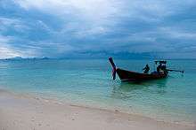
- Many of the outlying islands are very popular destinations for tourists, divers and snorkelers, including the Phi Phi Islands and the Similan Islands.
Local culture
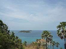
- Thao Thep Krasattri and Thao Si Sunthon Fair (งานท้าวเทพกระษัตรี - ท้าวศรีสุนทร) is held on March 13 every year to commemorate the two great heroines who rallied the Thalang people to repel Burmese invaders.
- Vegetarian Festival or Nine Emperor gods Festival (Hokkien Chinese language: 九皇勝會,Kiú-Hông Sēng-Huē or 九皇爺, Kiú-Hông Iâ) Phuket Chinese people Call 食菜節,Tsia̍h-tshài (เทศกาลกินเจ(กินผัก-เจี๊ยะฉ่าย)) is held on the first day of the 9th Chinese lunar month (end-Sep or early-Oct). Phuket islanders of Chinese ancestry commit themselves to a 9-day vegetarian diet, a form of purification believed to help make the forthcoming year trouble-free. The festival is marked by several ascetic displays, including fire-walking and ascending sharp-bladed ladders.[29]
- Ghost Festival or Phóo-tōo Festival (Hokkien Chinese language: 普渡節) Full name is Û-lân-phûn Sēng-Huē (Hokkien Chinese language: 盂蘭盆勝會) is held on the middle day of the 7th Chinese lunar month. Intrinsic to the Ghost Festival is ancestor worship. Activities include preparing food offerings, burning incense, and burning joss paper, a papier-mâché form of material items such as clothes, gold, and other goods for the visiting spirits. Elaborate meals (often vegetarian) are served with empty seats for each of the deceased in the family. Other festivities may include, buying and releasing miniature paper boats and lanterns on water, which signifies giving direction to lost souls.
- Phuket King's Cup Regatta (งานแข่งเรือใบชิงถ้วยพระราชทาน) is held in December. The Kata Beach Resort hosts yachtsmen, largely from neighbouring countries who compete for trophies.[30]
- Laguna Phuket Triathlon (ลากูน่าภูเก็ตไตรกีฬา) is held each December. The triathlon (a 1,800 metres (5,900 ft) swim, a 55 kilometres (34 mi) bike race and a 12 kilometres (7.5 mi) run and a 6 kilometres (3.7 mi) fun run) attracts athletes from all over the world.[31]
- Phuket Travel Fair (เทศกาลเปิดฤดูการท่องเที่ยวจังหวัดภูเก็ต), starting 1 November, is usually called the Patong Carnival, from the place where celebrations occur. Colourful parades, sports events, and a beauty competition for foreign tourists are major activities.
- Chao Le (Sea Gypsy) Boat Floating Festival (งานประเพณีลอยเรือชาวเล) falls during the middle of the sixth and eleventh lunar months yearly. The sea gypsy villages at Rawai and Sapam hold their ceremonies on the 13th; Ko Si-re celebrates on the 14th; and Laem La (east of the bridge on Phuket's northern tip) on the 15th. Ceremonies, which centre on the setting small boats adrift similar to the Thai festival of Loi Krathong, are held at night and their purpose is to drive away evil and bring good luck.
- Phuket Bike Week is the biggest motorcycle event in Asia that is held since 1995. Motorcyclists with their motorcycles and visitors from many countries join this event in every year. The event highlights include Motorcycle Exhibition, Bike Parades “Ride for Peace”, Custom Bike contests, Live Entertainment, Miss Phuket Bike Week competition, Bike accessories and Apparel from local and international venders.[32][33]
Cuisine
Local dishes include:

Phuket Chinese, Peranakan, and Malay Food
- Mee Hokkien (福建麵)- Hokkien noodles
- Hong-bah (封肉)
- A-sam Hê (亞參蝦)- Tamarind prawns
- Sam-bai Hê (參巴蝦)
- Sambal goreng (參巴Goreng)
- Tāu-iû Bah (豆油肉)- Sweet pork
- Jiû-hû Èng-tshài (鰇魚蕹菜)- Squid morning glory
- Po̍h-piánn (薄餅)- Spring rolls Hokkien- and Cantonese-style
- Lóo-bah (滷肉)- Fried spicy pork
- Iû-pn̄g (油飯)- Fried sticky rice
- Bí-hún Bah-kut (米粉肉骨)- Rice vermicelli bone noodle soup
- Tshá Mī-suànn (炒麵線)- Fried vermicelli
- Ô-tāu (蚵豆)- Fried oyster with taro
- Oo Dao (蚵豆)- Desi thalli Indian
- Steak (牛扒)- Chinese Steak
- Moo-hong - Stewed pork belly
Desserts
- Tāu-sòo Piánn (豆素餅)
- Âng-ku Kué (紅龜粿)- Red turtle sticky rice cake
- Tinn-Kué (甜粿)- Chinese year cake
- Tsut-bí Ka-ia̍h (糯米咖椰)- Sticky rice with egg custard
- Kue Talam
- Kue Bengka
- Káu-tsân Kué (九層粿)
- Pak Thong Ko (白糖糕)- White sugar sponge cake
- Huat-kué (發粿)
- Kue Ape - Malay-style pancake
- Bán-tsian Kué (曼煎粿)
- Phàng-piánn (胖餅)
- Ke-nn̄g Ko (雞卵糕)- Egg cake
Twin towns – sister cities
Phuket Province has a number of sister cities. They are:
 Nice, France (1989)
 Las Vegas, United States (1997)
 Yantai, China (1997)
 Port Blair, India (2005)[34]
 Hainan, China (2005)[35]
 Nakhodka, Russia (2006)[36]
 Suining, China (2016)[37]
References
- 1 2 "Phuket". Amazing Thailand. Tourism Authority of Thailand. Retrieved 2015-01-03.
- 1 2 3 4 Smithies, Michael (2002), Three military accounts of the 1688 "Revolution" in Siam, Itineria Asiatica, Orchid Press, Bangkok, ISBN 974-524-005-2
- ↑ ตราประจำจังหวัด . Retrieved 22 Oct 2013 from http://www.phuket.go.th
- ↑ กุศล เอี่ยมอรุณ, จตุพร มีสกุล. Phuket. Bangkok: Sarakadee Press.
- ↑ New Terrains in Southeast Asian History, p.294, Abu Talib
- ↑ A History of South-east Asia p. 350, by Daniel George Edward Hall (1964) St. Martin's Press
- ↑ "NOAA Provides First Tsunami Detection Buoy for the Indian Ocean". NOAA. Retrieved 2012-06-17.
- ↑ "Thailand Census 2010" (PDF). National Statistical Office Thailand. National Statistical Office Thailand. Retrieved 12 Sep 2014.
- ↑ Administrative Divisions of Thailand: Provinces and Districts - Statistics and Maps by City Population. Citypopulation.de (2011-11-12). Retrieved on 2013-08-25.
- ↑ http://stat.bora.dopa.go.th/stat/y_stat55.html
- ↑ Phuket Town Treasure Map www.phuket-maps.com
- ↑ "Sirinart National Park". Amazing Thailand. Tourist Authority of Thailand (TAT). Retrieved 2015-01-16.
- 1 2 "Climatological Data for the Period 1981–2010". Thai Meteorological Department. Retrieved 8 August 2016.
- 1 2 "ปริมาณการใช้น้ำของพืชอ้างอิงโดยวิธีของ Penman Monteith (Reference Crop Evapotranspiration by Penman Monteith)" (PDF) (in Thai). Office of Water Management and Hydrology, Royal Irrigation Department. Retrieved 8 August 2016.
- ↑ "Top rubber producers again eye joint moves to arrest sliding prices". Reuters. 6 Feb 2014. Retrieved 12 Sep 2014.
- ↑ "Phuket’s Economy".
- ↑ "Phuket 2015 Hotel Market Update" (PDF). C9 Hotel Works. Retrieved 22 May 2017.
- ↑ "Paradise Found: Where to Retire Abroad". CNN. July 11, 2005.
- ↑ Tristan Jones (1999). To Venture Further. Sheridan House, Inc. p. 53. ISBN 1-57409-064-X.
- ↑ Walter Armstrong Graham (1913). Siam: A Handbook of Practical, Commercial, and Political Information. F. G. Browne. pp. 115, 124.
- ↑ Annabelle Gambe (2000). Overseas Chinese Entrepreneurship and Capitalist Development in Southeast Asia. LIT Verlag Berlin-Hamburg-Münster. p. 108. ISBN 3-8258-4386-6.
- ↑ D'Oliveiro, Michael (2007-03-31). "The Peranakan Trail". The Star Online. The Star (Malaysia). Retrieved 2015-01-16.
- ↑ Phuket News: Phuket population "only" 525,000: Census. Phuketgazette.net. Retrieved on 2013-08-25.
- ↑ "รายงานสถิติจำนวนประชากรและบ้านประจำปี พ.ศ.2558". Department of Provincial Administration (DOPA). Retrieved 28 August 2016.
- ↑ "An evergreen dream". TTGmice. Retrieved 18 January 2013.
- ↑ "Two Heroines Monument". Amazing Thailand. Tourism Authority of Thailand. Retrieved 2015-01-03.
- ↑ "Phuket Museums". Amazing Thailand. Tourist Authority of Thailand. Retrieved 2015-01-03.
- ↑ "Phuket Pearl Farm". Phuket Pearl Shop. 2015-04-08. Retrieved 2016-01-21.
- ↑ "Vegetarian Festival, Phuket". Amazing Thailand. Tourism Authority of Thailand (TAT). Retrieved 2015-01-16.
- ↑ "Phuket King's Cup Regatta". Phuket King's Cup Regatta. Retrieved 2015-01-03.
- ↑ "Laguna Phuket Triathlon". Challenge; Laguna-Phuket Tri-Fest. Retrieved 2015-01-16.
- ↑ "Phuket Bike Week: 11-19 April 2015". Retrieved 2015-09-28.
- ↑ "22nd anniversary PHUKET BIKE WEEK 2016 on April 8-16, 2016 - at Patong Beach and Phuket Town, Phuket, Thailand". www.phuketbikeweek.com. Retrieved 2015-09-28.
- ↑ "List of twinned cities" (PDF). Ministry of Urban Development, India. Archived from the original (PDF) on 2011-07-17.
- ↑ "Sister Cities". Heinan Government.
- ↑ "Nakhodka celebrates the day of twin-cities". Nakhodka City Administration. 2009-04-24.
- ↑ "Phuket becomes sister city with Suining, China". Nakhodka City Administration. 2016-06-30.
External links
| Wikimedia Commons has media related to Phuket Province. |
- Forbes, Andrew, and Henley, David: Phuket’s Historic Peranakan Community
 Phuket travel guide from Wikivoyage
Coordinates: 7°53′24″N 98°23′54″E / 7.89000°N 98.39833°E

