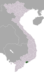
Phước Hải, Đất Đỏ
| Phước Hải | |
|---|---|
| Township | |
 Phước Hải Location in Vietnam | |
| Coordinates: 10°25′42″N 107°17′43″E / 10.42833°N 107.29528°ECoordinates: 10°25′42″N 107°17′43″E / 10.42833°N 107.29528°E | |
| Country |
|
| Province | Bà Rịa–Vũng Tàu |
| District | Đất Đỏ |
| Area | |
| • Total | 63.922 sq mi (165.558 km2) |
| Population (2006) | |
| • Total | 20,923 |
| Time zone | Indochina Time (UTC+07:00) |
Phước Hải is a township (thị trấn) in Đất Đỏ District, Bà Rịa–Vũng Tàu Province, Vietnam.
The township was founded in 2006 from 1,655.58 hectares with 20,923 inhabitants of the commune of Phước Hải. The neighboring communes arei: Lộc An to the east (district of Đất Đỏ); townlet of Long Hải to the west (district of Long Điền); South China Sea to the south, to the north it borders Long Mỹ and Phước Hội in Đất Đỏ District.[1]
References
This article is issued from
Wikipedia.
The text is licensed under Creative Commons - Attribution - Sharealike.
Additional terms may apply for the media files.
