Petting, Bavaria
| Petting | ||
|---|---|---|
|
Petting as viewed from South | ||
| ||
 Petting | ||
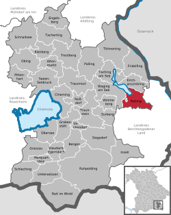
Location of Petting within Traunstein district  | ||
| Coordinates: 47°55′N 12°49′E / 47.917°N 12.817°ECoordinates: 47°55′N 12°49′E / 47.917°N 12.817°E | ||
| Country | Germany | |
| State | Bavaria | |
| Admin. region | Oberbayern | |
| District | Traunstein | |
| Government | ||
| • Mayor | Karl Lanzinger | |
| Area | ||
| • Total | 29.93 km2 (11.56 sq mi) | |
| Elevation | 451 m (1,480 ft) | |
| Population (2015-12-31)[1] | ||
| • Total | 2,321 | |
| • Density | 78/km2 (200/sq mi) | |
| Time zone | CET/CEST (UTC+1/+2) | |
| Postal codes | 83367, 83419 | |
| Dialling codes | 08686 | |
| Vehicle registration | TS | |
| Website | www.gemeinde-petting.de | |
Petting is a municipality in the district Traunstein, Bavaria, Germany. It is located on the shore of the Waginger See, a diluvial lake.
The first mention of the municipality was in 1048 with the name Pettinga; however, it is possible that the settlement already existed at the time of the Roman Empire. In 1180 it came into the ownership of the monastery St. Zeno.
References
- ↑ "Fortschreibung des Bevölkerungsstandes". Bayerisches Landesamt für Statistik und Datenverarbeitung (in German). June 2016.
External links
- Official website of the municipality (German)
This article is issued from
Wikipedia.
The text is licensed under Creative Commons - Attribution - Sharealike.
Additional terms may apply for the media files.

