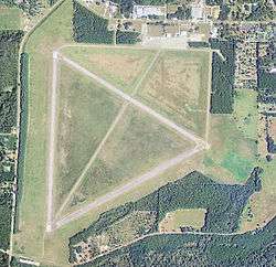
Perry–Foley Airport
| Perry–Foley Airport Perry Army Airfield | |||||||||||||||
|---|---|---|---|---|---|---|---|---|---|---|---|---|---|---|---|
|
2006 USGS airphoto | |||||||||||||||
| Summary | |||||||||||||||
| Airport type | Public use | ||||||||||||||
| Owner | Taylor County, Florida | ||||||||||||||
| Operator | Bill Roberts Airport Manager | ||||||||||||||
| Serves | Perry, Florida | ||||||||||||||
| Location | Taylor County, Florida | ||||||||||||||
| Elevation AMSL | 45 ft / 14 m | ||||||||||||||
| Coordinates | 30°04′20″N 083°34′42″W / 30.07222°N 83.57833°WCoordinates: 30°04′20″N 083°34′42″W / 30.07222°N 83.57833°W | ||||||||||||||
| Website | http://taylorcountygov.com/airport/index.htm[ Perry-Foley Airport] | ||||||||||||||
| Map | |||||||||||||||
 FPY Location of Perry–Foley Airport | |||||||||||||||
| Runways | |||||||||||||||
| |||||||||||||||
| Statistics (2017) | |||||||||||||||
| |||||||||||||||
Perry–Foley Airport (IATA: FPY, FAA LID: 40J) is a public-use airport located 3 miles (4.8 km) south of the central business district of the city of Perry in Taylor County, Florida, United States. The airport is publicly owned.[1]
History
During World War II, the airfield was constructed and used by the Third Air Force of the United States Army Air Forces for training.
Developed on 862 acres (3.49 km2), Perry Army Airfield became operational on 9 June 1943 as a sub-base to Dale Mabry Army Airfield in Tallahassee, Florida under the authority of the 338th Fighter Group of the Third Air Force.
Perry AAF was a replacement training unit, hosting the 312th and 441st Fighter Squadrons. Pilots received their final training in P-40 Warhawks, P-47 Thunderbolts, and P-51 Mustangs at Perry AAF prior to joining operational units in the European or Pacific theaters.
With the close of hostilities, the last military pilots left Perry AAF in September 1945. The airfield was subsequently deeded to Taylor County by the War Assets Administration in April 1947, and the field reverted to civilian aviation purposes. It has been used as a general aviation airfield ever since.[2]
See also
References
![]() This article incorporates public domain material from the Air Force Historical Research Agency website http://www.afhra.af.mil/.
This article incorporates public domain material from the Air Force Historical Research Agency website http://www.afhra.af.mil/.
- Maurer, Maurer (ed.). Combat Squadrons of the Air Force: World War II. Maxwell Air Force Base, Alabama: Office of Air Force History, 1982 ISBN 0-405-12194-6.
- Maurer, Maurer (ed.), Air Force Combat Units of World War II, History and Insignia, USAF Historical Divisio, Washington, DC, 1961 (reprint 1983) ISBN 0-89201-092-4
- Shaw, Frederick J. (2004), Locating Air Force Base Sites History’s Legacy, Air Force History and Museums Program, United States Air Force, Washington DC, 2004.
- World War II airfields database: Florida
- AFJRA Search Perry Army Airfield
External links
- Resources for this airport:
- FAA airport information for 40J
- AirNav airport information for 40J
- FlightAware airport information and live flight tracker
- SkyVector aeronautical chart for 40J
