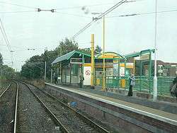
Percy Main Metro station
| Percy Main | |
|---|---|
| Tyne and Wear Metro | |
|
| |
|
Approaching Percy Main on an eastbound train | |
| Location | |
| Place | Percy Main |
| Local authority | North Tyneside |
| WGS84 | 54°59′59″N 1°28′29″W / 54.9996°N 1.4746°WCoordinates: 54°59′59″N 1°28′29″W / 54.9996°N 1.4746°W |
| Fare zone information | |
| Network One zone | 2 |
| Metro zone | B |
| Original (1979) zone | 28 |
| Station code | PCM |
| History | |
| Opened | 20 June 1839 |
| Closed for conversion | 11 August 1981 |
| Metro since | 14 November 1982 |
| List of stations | |
Percy Main Metro station is on the Yellow line of the Tyne and Wear Metro in the village of Percy Main in North Tyneside, England.
The original station of the Newcastle & North Shields Railway opened in 1839 to serve a small riverside community clustered around a colliery.[1] All of the original buildings were demolished when the station was converted for Metro use. The footbridge originally installed there by the North Eastern Railway has been preserved by the National Railway Museum in York.[2] The footbridge is very similar to one still in situ at South Gosforth station.
From here, it is a 2 kilometres (1.2 mi) walk to the DFDS Seaways ferry terminal, and to Royal Quays. Also, it is a short walk to the south terminus of the North Tyneside Steam Railway.
The Metro tracks cross the 55th parallel north line of latitude just east of Percy Main station.
The station is in between the Meadow Well and Howdon Metro stations.
External links
| Wikimedia Commons has media related to Percy Main Metro station. |
- Train times and station information for Percy Main Metro station from Nexus
- Route 19 website
References
- ↑ "Disused Stations: Percy Main Station". www.disused-stations.org.uk. Retrieved 2017-05-14.
- ↑ "Percy Main Bridge collection page". NRM Collections. National Railway Museum. Retrieved 2007-02-10.
| Preceding station | Tyne and Wear Metro | Following station | ||
|---|---|---|---|---|
towards St James | Yellow line | towards South Shields |
||
| |
||||
