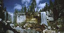
Paulina Creek Falls
| Paulina Creek Falls | |
|---|---|
 Paulina Creek Falls in the Summer | |
| Location | Deschutes County, Oregon |
| Coordinates | 43°42′44″N 43°42′44″W / 43.71222°N 43.71222°WCoordinates: 43°42′44″N 43°42′44″W / 43.71222°N 43.71222°W |
| Type | Cascade, Plunge |
| Elevation | 6,232 ft (1,900 m) |
| Total height | 80 ft (24 m) |
| Number of drops | 1 |
| Average width | 40 ft (12 m) |
| Average flow rate | 50 cu ft/s (1.4 m3/s) |
Paulina Creek Falls is a cascade and plunge waterfall from a streambed draining from Paulina Lake near Newberry National Volcanic Monument, south of Bend, Oregon. The waterfall is notable for its side-by-side drop of 80 feet (24 m) that surrounds a small island at the edge of the cliff.[1][2]
Trails
A paved foot out and back trail leads to Paulina Falls starting at the trailhead located at the Paulina Falls Day Use Area off Paulina Lake Road (Hw 21).[3] The trail leads to the bottom and the top of the waterfall. Road 21 into Newberry Caldera with access to Monument summer trails is closed in the winter due to snow.
See also
References
- ↑ "Paulina Creek Falls". Northwest Waterfall Survey. Retrieved 10 May 2017.
- ↑ Zach Urness (March 23, 2015). "Oregon Top 7: Best snowy waterfall hikes and snowshoe trips". Statesman Journal. Retrieved May 7, 2017.
- ↑ "Paulina Falls Day Use Area". USDA Forest Service. Retrieved 2016-05-12.
This article is issued from
Wikipedia.
The text is licensed under Creative Commons - Attribution - Sharealike.
Additional terms may apply for the media files.