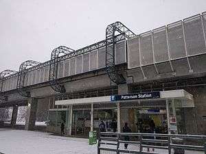
Patterson station
| SkyTrain station | |||||||||||||||
 | |||||||||||||||
| Location |
4101 Beresford Street, Burnaby Canada | ||||||||||||||
| Coordinates | 49°13′47″N 123°00′45″W / 49.22967°N 123.012376°WCoordinates: 49°13′47″N 123°00′45″W / 49.22967°N 123.012376°W | ||||||||||||||
| Owned by | BC Transit, TransLink | ||||||||||||||
| Platforms | Centre platform | ||||||||||||||
| Tracks | 2 | ||||||||||||||
| Construction | |||||||||||||||
| Structure type | Elevated | ||||||||||||||
| Disabled access | Yes | ||||||||||||||
| Other information | |||||||||||||||
| Station code | PT | ||||||||||||||
| Fare zone | 2 | ||||||||||||||
| History | |||||||||||||||
| Opened | December 11, 1985 | ||||||||||||||
| Traffic | |||||||||||||||
| Passengers (2011[1]) | 10,607 | ||||||||||||||
| Services | |||||||||||||||
| |||||||||||||||
The Patterson station of the SkyTrain system is an elevated station located on the Expo Line in Burnaby, British Columbia, Canada. It is the westernmost Expo Line station in Burnaby.
Location
The station is located at the northeastern fringe of Burnaby's Central Park, at the corner of Patterson Avenue and Central Boulevard. A stretch of the SkyTrain line west of the station actually crosses through the park.
This station is located above the old rights-of-way of the now-defunct British Columbia Electric Railway Central Park Line; this line ran from just west of Nanaimo station all the way to where the current New Westminster station is located.
History
Patterson station was built in 1985 as part of the original Expo Line. Even considering its proximity to Central Park - a very lush, wooded park with trails to Swangard Stadium, the station is primarily used by local residents in the area. This lack of use can also be attributed to its proximity to the Metrotown station. Patterson station is where Diana, Princess of Wales and Prince Charles disembarked after riding the SkyTrain from Waterfront station during Expo 86. The station was named for pioneer Dugald Campbell Patterson who built the original interurban stop, then known as Patterson's Landing, along the old British Columbia Electric Railway in the 1890s.
Bus service
- Bus bay assignments;[2]
- 1 - 129 Edmonds station
- 2 - Unloading Only
- 3 - 125 BCIT
- Metrotown Shuttle
References
- ↑ "2011 SkyTrain Station Counts". TransLink. Retrieved August 10, 2016.
- ↑ Map of Paterson Station