Patnongon, Antique
| Patnongon | |
|---|---|
| Municipality | |
|
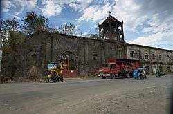
Patnongon Church | |
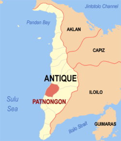
 Location within Antique province | |
.svg.png) Patnongon Location within the Philippines | |
| Coordinates: 10°55′N 121°59′E / 10.92°N 121.98°ECoordinates: 10°55′N 121°59′E / 10.92°N 121.98°E | |
| Country | Philippines |
| Region | Western Visayas (Region VI) |
| Province | Antique |
| District | Lone district |
| Barangays | 36 (see Barangays) |
| Government [1] | |
| • Type | Sangguniang Bayan |
| • Mayor | Johnnyflores S. Bacongallo |
| Area [2] | |
| • Total | 167.92 km2 (64.83 sq mi) |
| Population (2015 census)[3] | |
| • Total | 37,176 |
| • Density | 220/km2 (570/sq mi) |
| • Voter (2016)[4] | 19,248 |
| Demonym(s) | Patnonganons |
| Time zone | PST (UTC+8) |
| ZIP code | 5702 |
| IDD : area code | +63 (0)36 |
| Income class | 3rd class |
| PSGC | 060612000 |
| Website |
elgu |
Patnongon, officially the Municipality of Patnongon (Karay-a: Banwa kang Patnongon; Hiligaynon: Banwa sang Patnongon; Filipino: Bayan ng Patnongon), is a municipality in the province of Antique in the Western Visayas (Region VI) of the Philippines. The population was 37,176 at the 2015 census.[3] In the 2016 electoral roll, it had 19,248 registered voters.[4]
Patnongon is 25 kilometres (16 mi) from the provincial capital, San Jose de Buenavista.
Geography
Patnongon is located at 10°55′N 121°59′E / 10.92°N 121.98°E.
According to the Philippine Statistics Authority, the municipality has a land area of 167.92 square kilometres (64.83 sq mi) [2] constituting 6.15% of the 2,729.17-square-kilometre- (1,053.74 sq mi) total area of Antique.
Barangays
Patnongon is politically subdivided into 36 barangays.[5]
| PSGC | Barangay | Population | ±% p.a. | |||
|---|---|---|---|---|---|---|
| 2015[3] | 2010[6] | |||||
| 060612001 | Alvañiz | 0.7% | 257 | 212 | 3.73% | |
| 060612002 | Amparo | 2.0% | 725 | 676 | 1.34% | |
| 060612003 | Apgahan | 4.5% | 1,671 | 1,573 | 1.16% | |
| 060612004 | Aureliana | 6.9% | 2,551 | 2,272 | 2.23% | |
| 060612005 | Badiangan | 2.0% | 725 | 685 | 1.09% | |
| 060612006 | Bernaldo A. Julagting (Bitas) | 2.1% | 786 | 749 | 0.92% | |
| 060612007 | Carit-an | 5.4% | 2,018 | 1,912 | 1.03% | |
| 060612008 | Cuyapiao | 2.8% | 1,050 | 1,020 | 0.55% | |
| 060612010 | Gella | 1.1% | 416 | 388 | 1.34% | |
| 060612011 | Igbarawan | 4.2% | 1,565 | 1,418 | 1.90% | |
| 060612012 | Igbobon | 2.0% | 742 | 597 | 4.23% | |
| 060612013 | Igburi | 3.4% | 1,260 | 998 | 4.54% | |
| 060612014 | La Rioja | 6.1% | 2,278 | 2,266 | 0.10% | |
| 060612015 | Mabasa | 3.1% | 1,151 | 1,032 | 2.10% | |
| 060612016 | Macarina | 1.9% | 689 | 659 | 0.85% | |
| 060612017 | Magarang | 1.2% | 441 | 355 | 4.22% | |
| 060612018 | Magsaysay | 4.1% | 1,533 | 1,457 | 0.97% | |
| 060612019 | Padang | 4.5% | 1,663 | 1,576 | 1.03% | |
| 060612020 | Pandanan | 2.6% | 953 | 911 | 0.86% | |
| 060612021 | Patlabawon | 1.3% | 494 | 453 | 1.66% | |
| 060612022 | Poblacion | 16.3% | 6,044 | 5,701 | 1.12% | |
| 060612023 | Quezon | 0.9% | 346 | 314 | 1.86% | |
| 060612024 | Salaguiawan | 1.4% | 539 | 468 | 2.73% | |
| 060612025 | Samalague | 2.6% | 970 | 1,541 | −8.44% | |
| 060612026 | San Rafael | 2.2% | 829 | 803 | 0.61% | |
| 060612028 | Tamayoc | 3.6% | 1,330 | 1,304 | 0.38% | |
| 060612029 | Tigbalogo | 1.5% | 570 | 541 | 1.00% | |
| 060612027 | Tobias Fornier | 1.2% | 441 | 411 | 1.35% | |
| 060612030 | Villa Crespo | 1.2% | 463 | 413 | 2.20% | |
| 060612031 | Villa Cruz | 1.5% | 543 | 446 | 3.82% | |
| 060612009 | Villa Elio | 1.2% | 429 | 386 | 2.03% | |
| 060612032 | Villa Flores | 0.5% | 191 | 175 | 1.68% | |
| 060612033 | Villa Laua-an | 0.9% | 340 | 306 | 2.03% | |
| 060612034 | Villa Sal | 0.7% | 271 | 236 | 2.67% | |
| 060612035 | Villa Salomon | 1.1% | 423 | 390 | 1.56% | |
| 060612036 | Vista Alegre | 1.3% | 479 | 458 | 0.86% | |
| Total | 37,176 | 35,102 | 1.10% | |||
Demographics
| Population census of Patnongon | ||
|---|---|---|
| Year | Pop. | ±% p.a. |
| 1903 | 14,319 | — |
| 1918 | 15,721 | +0.62% |
| 1939 | 20,012 | +1.16% |
| 1948 | 23,145 | +1.63% |
| 1960 | 23,207 | +0.02% |
| 1970 | 22,443 | −0.33% |
| 1975 | 22,643 | +0.18% |
| 1980 | 24,262 | +1.39% |
| 1990 | 27,376 | +1.22% |
| 1995 | 29,235 | +1.24% |
| 2000 | 31,555 | +1.65% |
| 2007 | 33,694 | +0.91% |
| 2010 | 35,102 | +1.50% |
| 2015 | 37,176 | +1.10% |
| Source: Philippine Statistics Authority[3][6][7][8] | ||
In the 2015 census, Patnongon had a population of 37,176.[3] The population density was 220 inhabitants per square kilometre (570/sq mi).
In the 2016 electoral roll, it had 19,248 registered voters.[4]
Attractions
- Amihan Beach Resort in La Rioja
- La Parola Orchids Beach Resort in Brgy. Amparo
- Igbarawan Garden Resort in Igbarawan
- Bato-Bugtong Beach and resort in Igbarawan
- Apgahan Beach Resort / San Ramon Beach Resort
- Bato Tibi of Tamayoc
- Villa Alma Beach Resort in Padang
- Mountain Climbing in small mountains near Padang, Apgahan, Aureliana, La-Rioja and Aureliana where one can find fruit‑bearing wild trees
- Old Municipal Building Constructed by Spaniards
- Old Spanish Church Convent now Saint Augustine's Academy of Patnongon, Inc. old building
- Spelunking in Kuweba Dapa and Kuweba Turu-ong in Brgy. San Rafael
- Shrine of Rosa Mystica in Tigmanali
- Linaw-Balud Falls in Brgy. Igburi
- Lipunto Range in Brgy. Patlabawon
References
- ↑ "Municipality". Quezon City, Philippines: Department of the Interior and Local Government. Retrieved 31 May 2013.
- 1 2 "Province: Antique". PSGC Interactive. Quezon City, Philippines: Philippine Statistics Authority. Retrieved 12 November 2016.
- 1 2 3 4 5 Census of Population (2015). "Region VI (Western Visayas)". Total Population by Province, City, Municipality and Barangay. PSA. Retrieved 20 June 2016.
- 1 2 3 "2016 National and Local Elections Statistics". Commission on Elections. 2016.
- ↑ "Municipal: Patnongon, Antique". PSGC Interactive. Quezon City, Philippines: Philippine Statistics Authority. Retrieved 8 January 2016.
- 1 2 Census of Population and Housing (2010). "Region VI (Western Visayas)". Total Population by Province, City, Municipality and Barangay. NSO. Retrieved 29 June 2016.
- ↑ Census of Population (1995, 2000 and 2007). "Region VI (Western Visayas)". Total Population by Province, City and Municipality. NSO. Archived from the original on 24 June 2011.
- ↑ "Province of Antique". Municipality Population Data. Local Water Utilities Administration Research Division. Retrieved 17 December 2016.
| Adjacent places of Patnongon, Antique | ||||
|---|---|---|---|---|
 |
Bugasong | Valderrama |  | |
| Sulu Sea | |
|||
| ||||
| | ||||
| Belison | San Remigio | |||
