Pali-Aike National Park
| Pali-Aike National Park | |
|---|---|
|
IUCN category II (national park) | |
 | |
| Location | Magallanes Region, Chile |
| Nearest city | Punta Arenas |
| Coordinates | 52°06′S 69°44′W / 52.100°S 69.733°WCoordinates: 52°06′S 69°44′W / 52.100°S 69.733°W |
| Area | 5,030 ha (12,429 acres)[1] |
| Established | October 23, 1970 |
| Visitors | 2,537[2] (in 2016) |
| Governing body | Corporación Nacional Forestal |
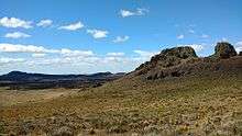
The Pali-Aike National Park is a park located in the Magallanes Region of the Chilean Patagonia. Pali-Aike is a Tehuelche name that means Desolate Place. Created in 1970, it covers an area of 5,030 hectares (12,429 acres)[1] and includes part of the Pali-Aike Volcanic Field. The park draws its name from a prominent volcanic cone known as the Pali Aike Crater.[3] Human crania from early prehistoric occupation have been recovered from this Pali Aike Crater site.[4]
Gallery

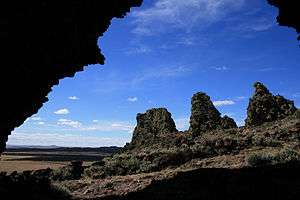
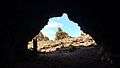 Pali Aike Cave
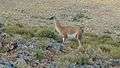 Guanaco inside the park
See also
Notes
- 1 2 "National Parks of Chile". CONAF. Retrieved 2 April 2017.
- ↑ "Visitor Statistics" (PDF). National Forest Corporation (Chile). 31 January 2017. p. 3. Retrieved 2 April 2017.
- ↑ T. Moreno, 2005
- ↑ G. Wisner, 2008
References
- Teresa Moreno and Wes Gibbons (2007) The Geology of Chile, Geological Society of London, 414 pages ISBN 1-86239-220-X
- George Wisner: In the footsteps of Junius Bird, Part I: Bird the person. Mammoth Trumpet 23(4), 2008, pp.17-20.
External links
| Wikimedia Commons has media related to Pali Aike National Park. |
This article is issued from
Wikipedia.
The text is licensed under Creative Commons - Attribution - Sharealike.
Additional terms may apply for the media files.