Palar River
| Palar River | |
|---|---|
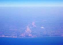
 The mouth of the Palar river, seen from the air | |
 Map showing the river | |
| Other name(s) | |
| Basin features | |
| Main source | Nandi Hills in Karnataka, India |
| River mouth | Bay of Bengal |
| Physical characteristics | |
| Length | 216 mi (348 km) |
Palar (Tamil: பாலாறு), (Kannada: ಪಾಲಾರ್ ನದಿ), (Telugu: పాలార్ నది) is a river of southern India. It rises in Nandi Hills, India in Kolar district of Karnataka state,[1] and flows 93 kilometres (58 mi) in Karnataka, 33 kilometres (21 mi) in Andhra Pradesh and 222 kilometres (138 mi) in Tamil Nadu before its confluence into the Bay of Bengal at Vayalur about 100 kilometres (62 mi) south of Chennai.[2] It flows as an underground river for a long distance only to emerge near Bethamangala town, from where, gathering water and speed, it flows eastward down the Deccan Plateau. The cities of Ramanaickenpet, Vaniyambadi, Ambur, Gudiyatham, Vellore, Melvisharam, Arcot, Ranipet Walajapet (Anaicut), Kanchipuram, and Chengalpattu are located on banks of Palar River. Of all the total of seven tributaries, the chief tributary is Cheyyar River.
Palar river water from Palar anicut is diverted to the Poondi reservoir located in Kosasthalaiyar River basin and to Chembarambakkam Lake located in Adayar River basin.[3] These two reservoirs are major water supply points to Chennai city. After commissioning of the Telugu Ganga project to supply nearly 1000 million litres per day of Krishna River water to the Chennai city, the dependence on Palar river water has reduced drastically.

Controversial dam
Andhra Pradesh Government is constructing an irrigation dam across Palar at Ganeshpuram, near Kuppam, Andhra Pradesh which has caused agitation among the people of the five northern districts of Tamil Nadu, namely Vellore, Kancheepuram, Tiruvannamalai, Thiruvallur and Chennai benefited by the river. Tamil Nadu Chief Minister Jayalalitha voiced her opposition to this proposal and said "Palar is an inter-state river and was also one of the rivers mentioned in Schedule A annexed to the 1892 agreement[4] which is in force as per Interstate River Water Disputes Act 1956. As per a clause of the agreement, the upstream state should not build any new dam or any structure to obstruct, divert, or store waters of the rivers without the consent of the downstream state".[5][6]
The average rainfall in entire Palar river basin is low. This river basin used to suffer from frequent droughts. There has been no full scale flow for the past 10 years.However, Karnataka and Tamil Nadu have mitigated frequent recurrence of droughts by developing innumerable minor and medium irrigation tanks. This has improved the availability of water for surface as well as ground water irrigations. As per the wet land atlas of India.,[7] the manmade wet lands are covering extensive area (3% to 5%) in the districts of Karnataka and Tamil Nadu covering Palar river basin. Whereas the Palar basin in Andhra Pradesh is not well covered by wet lands which implies that the river water usage in Andhra Pradesh is not up to the mark compared to Karnataka and Tamil Nadu. In the year 1892 when the Palar waters agreement was made, Tamil Nadu and Andhra Pradesh were part of then Madras Presidency.[8] The 1892 agreement on Palar river water sharing is applicable between Karnataka and Andhra Pradesh since the boundary line in Palar river basin between Madras Presidency and Mysore kingdom is now part of Karnataka and Andhra Pradesh states.
Documentary
A documentary called "En Peyar Palar" produced by Social Action Movement and Water Rights Protection Group, Chengalpattu and released on 30 June 2008 chronicles the plight of the river from its origin in Karnataka till it joins Bay of Bengal. The 85-minute documentary delves into how activities such as sand quarrying and discharge of industrial effluents are sucking the life out of one of Tamil Nadu’s prime sources of drinking water. It was directed by R.R. Srinivasan.[9]
This river is so important for irrigation in the north and south Arcot districts of Tamil Nadu, but it flows a meager distance of 50 kilometres (31 mi) in Andhra Pradesh, where the Palar river had been seen dry for almost 20 years. Palar has been home for mud robbery and other illegal activities.
Temples
Venugopalaswami Temple is a historic temple located on the banks of the river.[10]
Palar water flow near Vellore in 2015
It was a sight to behold for residents of Vellore as water flowed into the Palar near Pallikonda on Tuesday breathing life into the dry river after almost 10 years. “Water has reached for more than four kilometres from Pallikonda bridge to Kandaneri. Palar is witnessing water flow after 10 years” an official said. Water level has gone up in the Aanaimadagu dam near Ambur. There was heavy water flow at the Jalagamparai and Amirthi water falls following the rains.[11]
See also
References
- ↑ Palar river
- ↑ Dam across the Palar is not feasible: State officials
- ↑ "Palar Anicut". Retrieved 21 May 2016.
- ↑ 1892 Agreement - pages 279 to 293
- ↑ TN against AP making dam on Palar river
- ↑ "Ponnala defends dam across Palar". The Hindu. 26 September 2010. Retrieved 21 May 2011.
- ↑ Wet lands of India 2011
- ↑ "Map of Madras Presidency in 1909". Retrieved 1 July 2016.
- ↑ A documentary charts the plight of Palar
- ↑ Padmaja, T. Temples of Kr̥ṣṇa in South India: History, Art, and Traditions in Tamilnāḍu. Abhinav Publications. p. 88. ISBN 9788170173984.
- ↑ http://www.thehindu.com/news/national/tamil-nadu/water-flows-into-palar-after-almost-a-decade/article7868057.ece
External links
| Wikimedia Commons has media related to Palar River. |
- The Palar research program by French CNRS. This website describe geographic questions about Palar country.
Coordinates: 12°28′04″N 80°09′16″E / 12.46778°N 80.15444°E


