Palace Albanija
| Palace Albanija | |
|---|---|
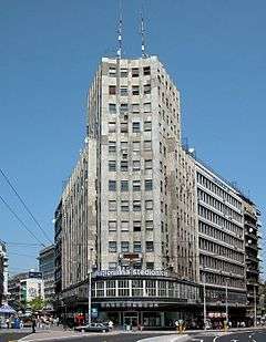 Palace Albanija in 2010. | |
| General information | |
| Architectural style | Modernist style |
| Location | Belgrade, Serbia |
| Completed | 1940 |
| Technical details | |
| Floor count | 13 |
| Design and construction | |
| Architect |
Miladin Prljević Đorđe Lazarević |
| Other designers |
Branko Bon Milan Grakalić |

Palace Albanija (Serbian: Палата »Албанија«, Palata »Albanija«, English: Palace Albania) is a high-rise building in Belgrade, Serbia. Opened in 1940, was the first skyscraper in Southeast Europe.
It is located at the north-west end of Terazije square. It was finished in 1940. It was designed by Miladin Prljević and Đorđe Lazarević, based on the 1938 project by Branko Bon and Milan Grakalić. It was the first highrise building in Belgrade and for a long time the tallest one, dominating the architecture of Belgrade of the time. The origin of its name is traced back to the period before it was built, since the kafana named Albanija previously occupied the same spot.
Though small but highly popular, the demolition of the old kafana Albanija sparked mass demonstrations in 1938.[1] The project envisioned three floors below the ground. As the city government had no machinery required for the job, they invited the Kalmyks, emigrants from Russia, noted for their horses. With their horses and carts, the Kalmyks removed the rubble and earth from the foundation pit.[2]
The building was hit during the heavy „Easter bombing“ of Belgrade by the Allies on 16 April 1944.[3] On October 20, 1944, Yugoslav flag with red star placed on Palace Albanija declared that Belgrade was liberated from the Nazis by the Red Army and Yugoslav Partisan forces. To this day it is the highest reference point between Terazije and Slavija.
References
- ↑ Slobodan Kljakić (25 March 2012), "Na Dorćolu otvorena prva kafana u Evropi", Politika (in Serbian)
- ↑ Dimitrije Bukvić (27 March 2017). "Potomci Džingis Kana u Beogradu". Politika. p. 9.
- ↑ J. Gajić (15–16 April 2017). "Na praznik padale bombe" (in Serbian). Politika. p. 27.
Coordinates: 44°48′54″N 20°27′36″E / 44.81500°N 20.46000°E