Puerto Rico Highway 14
| ||||
|---|---|---|---|---|
 | ||||
| Route information | ||||
| Maintained by DTOP | ||||
| Existed: | 1886 (as the old Carretera Central) – present | |||
| Major junctions | ||||
| North end: |
| |||
| ||||
| South end: |
| |||
| Highway system | ||||
| ||||
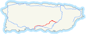
Puerto Rico Highway 14 is a main highway connecting Cayey, Puerto Rico to Ponce, Puerto Rico. The road uses the same path as the historic old Carretera Central.
Road description
Except in the city of Ponce where, with the exception of the Ponce Historic Zone, the road is a 4-lane road, the rest of PR-14 is a two-lane country road as it makes its way through the four towns it runs through, Juana Diaz, Coamo, Aibonito and Cayey. PR-14 is one of the roads that lead into the historic Ponce city center.[1]

PR-14 in Ponce approaching PR-10
Major intersections
- Puerto Rico Highway 1
- Puerto Rico Highway 206
- Puerto Rico Highway 721
- Puerto Rico Highway 138
- Puerto Rico Highway 149
- Puerto Rico Highway 506
- Puerto Rico Highway 10
- Puerto Rico Highway 139
- Puerto Rico Highway 505
- Puerto Rico Highway 12
- Puerto Rico Highway 1
See also
References
External links
- Carretera Militar/Military Road Porto Rico. Overland Monthly and Out West Magazine. Page 321. Retrieved 27 July 2013.
This article is issued from
Wikipedia.
The text is licensed under Creative Commons - Attribution - Sharealike.
Additional terms may apply for the media files.


