Ōsumi Islands
| Native name: 大隅諸島 Ōsumi-shotō | |
|---|---|
 Tanegashima Space Center | |
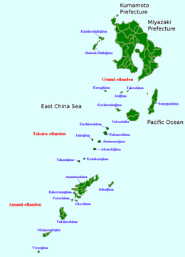
 Map of Kagoshima Prefecture | |
| Geography | |
| Coordinates | 30°34′26″N 130°58′52″E / 30.57389°N 130.98111°E |
| Adjacent bodies of water | Pacific Ocean |
| Total islands | 9 |
| Area | 1,030 km2 (400 sq mi) |
| Administration | |
| Prefectures | Kagoshima |
| Demographics | |
| Population | 46500 (2010) |
| Ethnic groups | Japanese |
The Ōsumi Islands (大隅諸島 Ōsumi-shotō) is an archipelago in the Nansei Islands, and are the northernmost group of the Satsunan Islands, which is in turn part of the Ryukyu Archipelago. The chain extends from the southern tip of Kyushu and Amami-Oshima. Administratively, the group belongs Kagoshima Prefecture, Japan.
Geography
The Ōsumi Islands are of volcanic origin and have a total area of approximately 1,030 square kilometres (400 sq mi). The highest elevation is Miyanouradake with a height of 1,935 metres (6,348 ft) on Yakushima. The climate is a humid subtropical climate (Köppen climate classification Cfa) with very warm summers and mild winters. Precipitation is high throughout the year, but is highest in the months of May, June and September.
History
The Ōsumi Islands have been settled since at least the Jōmon period. Burial sites on Tanegashima, namely the Yokomine and Hirota sites, attest to a uniquely well-developed Yayoi period culture at the end of the 4th century AD.[1] The artifacts include magatama, an engraved pendant, and emblems with apparent writing.[2]
Tanegashima and Yakushima are first mentioned in written documents of the Chinese Sui dynasty of the 6th century. Mention is made in the Japanese Shoku Nihongi under an entry for the year 699 of the islands of Tane, Yaku and Amami. The Ōsumi Islands formed ancient Tane Province during the Asuka period. The islands were often mentioned in the diaries of travelers between Tang-dynasty China and Nara period Japan.
Some of the islands in the archipelago have local legends of providing refuge to the Heike clan after their defeat in the Genpei War at the end of the Heian period. During the Sengoku period, in 1543 a Chinese vessel with the Portuguese Mendes Pinto stranded on Tanegashima and is credited with introducing sugarcane and firearms to Japan. Until modern times firearms were colloquially known in Japan as "Tanega-shima," due to the belief that they were introduced by Pinto. In fact, Pinto was probably not present at the first Portuguese contact with the Japanese, although he did visit Tanegashima soon after and legend says he did marry a local woman and had a son. The Europeans had arrived to trade not only guns, but also soap, tobacco and other goods unknown in medieval Japan, for Japanese goods.
During the Edo period, Ōsumi Islands were ruled by the Shimazu clan of Satsuma Domain and was considered part of Ōsumi Province. Following the Meiji Restoration, the islands have been administered as part of Kagoshima Prefecture.
In 1969 the "Tanegashima Space Center" (TNSC) including a spaceport was opened by the Japan Aerospace Exploration Agency. The TNSC is located at the southeastern end of Tanegashima island.
Transport
The Ōsumi Islands are served by New Tanegashima Airport and Yakushima Airport. There are regular connections with Kagoshima and the Amami Islands by ferries.
Islands
| Photo | Name | Kanji | Area [km²] | Population | highest point [m] | Peak | Coordinates |
|---|---|---|---|---|---|---|---|
 |
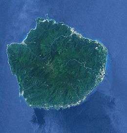
Yakushima | 屋久島 | 504.88 | 13,178 | 1935 | Miyanouradake | 30°21′31″N 130°31′43″E / 30.35861°N 130.52861°E |
 |
Tanegashima | 種子島 | 444.99 | 33,000 | 282.0 | 30°34′26″N 130°58′52″E / 30.57389°N 130.98111°E | |
| |
Kuchinoerabu-jima | 口永良部島 | 38.04 | 147 | 657 | Furudake | 30°28′N 131°11′E / 30.467°N 131.183°E |
| |
Mageshima | 馬毛島 | 8.2 | – | 71.7 | Takenokoshi | 30°44′29.9″N 130°51′16.9″E / 30.741639°N 130.854694°E |
| |
Kuroshima | 黒島 | 15.37 | 199 | 621.9 | Yaguradake | 30°50′5.6″N 129°57′20.7″E / 30.834889°N 129.955750°E |
| |
Iōjima | 硫黄島 | 11.65 | 142 | 703.7 | Iōdake | 30°47′27″N 130°17′46″E / 30.79083°N 130.29611°E |
| Takeshima | 竹島 | 4.2 | 78 | 220.0 | Magomeyama | 30°48′50″N 130°25′2.1″E / 30.81389°N 130.417250°E | |
| |
Shōwa Iōjima | 昭和硫黄島 | 0.07 | – | 24 | 30°48′15″N 130°20′30″E / 30.80417°N 130.34167°E | |
| |
Denshima | デン島 | 0.001 | - | 58 | 30°45′02″N 130°06′07″E / 30.75056°N 130.10194°E | |
References
- National Geospatial Intelligence Agency (NGIA). Prostar Sailing Directions 2005 Japan Enroute. Prostar Publications (2005). ISBN 1577856511
- ↑ "Hirota". Archaeology.jp. Retrieved 2013-09-30.
- ↑ "Ancient Japanese writing symbols [From the Golden Stamp to Documents from the Shoso-in]|Special Exhibitions|Exhibitions|National Museum of Japanese History". Rekihaku.ac.jp. 2002-06-09. Retrieved 2013-09-30.
External links
| Wikimedia Commons has media related to Osumi Islands. |