Orwell Bridge
The Orwell Bridge was opened to road traffic in 1982 and carries the A14 (then A45) over the River Orwell just south of Ipswich in Suffolk, England.
History
Construction of the bridge commenced in October 1979 and was completed in December 1982.
Bridge bearing replacement works were carried out by Jackson Civil Engineering Ltd during a 52-hour closure of the north deck, carrying the eastbound A14, over the weekend of 11–14 February 2011. The new bridge bearings were designed and manufactured by the engineering company, Freyssinet Ltd.[1]
In February 2014 a meeting of various agencies was held to review to review diversions when A14 and Orwell Bridge are forced to close.[2]
A permanent reduced speed limit of 60 mph was introduced in November 2015 for safety reasons.[3]
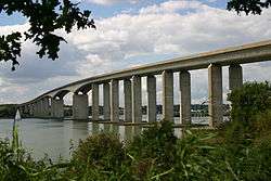
Design
The main span is 190 metres which, at the time of its construction, was the longest pre-stressed concrete span in use. The total length is 1,287 metres from Wherstead to the site of the former Ipswich Airport. The width is 24 metres with an air draft of 43 metres. Pilings were sunk 40 metres into the river bottom. The main contractor was Stevin Construction B.V. - a Dutch company. The main span was constructed by using a balanced cantilever technique, casting sections on alternating sides of the pier in a weekly cycle.
The bridge is constructed of a pair of continuous concrete box girders with expansion joints that allow for expansion and contraction. The girders are hollow, allowing for easier inspection, as well as providing access for services, including telecom, power and a 711mm water main from the nearby Alton Water reservoir. The necessary inspections still cause major disruption to traffic every six years; during the last inspection in the summer of 2005 the delays caused by lane closures and speed restrictions added between 30 and 60 minutes to journey times during the peak commuting periods.
The bridge design took into consideration the impact on the Orwell Estuary, as well as the needs of the port of Ipswich. The location close to the southern edge of Ipswich was chosen to be convenient for the industrial areas of the West Bank Terminal and Ransomes Industrial Estate on the eastern end. The bridge was set at an angle to the river to get the best relationship to the surrounding terrain.
The air draft of the central span was chosen to be as low as possible without adversely affecting port operations. Although some have said that the resulting hump affects visibility and road safety, there have not been enough incidents causing injury for the Highways Agency to identify it for greater detailed investigation and possible amendments.[4] The consulting engineers were Sir William Halcrow and Partners. Frederick Gibberd Partners worked on the project to ensure the bridge was as sympathetic as possible to its surroundings, with the final design winning the approval of the Royal Fine Art Commission.
The Department for Transport funded the project and, partly because of the bridge, paid for radars and cameras to be installed at the port's Orwell Navigation Service to monitor the river and the bridge.
Usage
As of 2006 the bridge was used by 60,000 vehicles using it per day, which was about 83% of its capacity.[5] In 2006 it was predicted that the bridge is expected to be running at over capacity by 2015.[6]
Incidents
Total closures
When the bridge is closed in both directions for more than a short period of time, normally as a safety precaution due to high winds, most of Ipswich's roads are brought to to near-standstill by diverted traffic.[7][8]
| Date | Duration (hours) | Reason | Note |
|---|---|---|---|
| 23 February 2017[7] | 5+ hours | High winds | Storm Doris |
| 22 November 2016[8][9] | 5+ hours | High winds | Storm Angus |
| 28 March 2016[10] | 5+ hours | High Winds | Storm Katie |
| 1 July 2015[11] | 0-1 hours | Suicide / Attempted Suicide | |
| 15 April 2015[11] | 1-1.5 hours | Road Traffic Collision | |
| 16 December 2014[11] | 1-1.5 hours | Pedestrian | |
| 29 October 2014[11] | 0-1 hours | Suicide / Attempted Suicide | |
| 21 July 2014[11] | 0-1 hours | Suicide / Attempted Suicide | |
| 13 June 2014[11] | 0-1 hours | Pedestrian | |
| 14 February 2014[12] | 5+ hours | High winds | 2013–14 United Kingdom winter floods |
| 28 October 2013[13] | 5+ hours | High winds | St. Jude storm |
| 4 March 2012[11][14] | 5+ hours | Road Traffic collision | Bridge closed from 8pm on 4th to 3am on 5th. |
Popular culture
The bridge appears in the 1987 Cold War drama The Fourth Protocol, in which two RAF helicopters are shown flying under it, and at the end of the 2014 film The Numbers Station.
External links
- Orwell Bridge High Wind Protocol - Briefing paper
- Ipswich, the A14 and the Orwell Bridge 26 January 2017 Highways Agency
- A14 Orwell Bridge Study - Technical note March 2013
References
- ↑ Freyssinet Bearing Replacement on A14 Orwell Bridge
- ↑ "Ipswich/Suffolk: Summit to look at diversions when A14 and Orwell Bridge are forced to close".
- ↑ "Safety improvement work begins on Orwell Bridge".
- ↑ Chenery, Roger (4 February 2005). "Road safety on the A14 around Ipswich". Highways Agency.
- ↑ "Newmarket to Felixstowe Corridor Study (Section 4.16)" (PDF). East of England Regional Assembly. Retrieved 19 June 2006.
- ↑ "Port of Felixstowe South Reconfiguration Evidence (Section 7.4)" (PDF). Planning Inspectorate. Retrieved 19 June 2006.
- 1 2 "A14 Orwell Bridge to stay open today as region deals with aftermath of Storm Doris".
- 1 2 "Orwell Bridge fully reopens after high winds closed A14 over the river and caused traffic disruption for thousands around Ipswich".
- ↑ "Orwell Bridge in Suffolk re-opens".
- ↑ "Storm Katie wreaks havoc across the East".
- 1 2 3 4 5 6 7 "Orwell Bridge Closures".
- ↑ "Suffolk/Essex: Orwell Bridge due to re-open this morning following strong overnight winds".
- ↑ "Big storm: Orwell Bridge reopened in both directions as St Jude’s storm begins to subside".
- ↑ No further details of this incident available from local news outlets such as East Anglian Daily Times
Coordinates: 52°01′37″N 1°09′52″E / 52.026909°N 1.16449°E