Oregon Route 224
| ||||
|---|---|---|---|---|
 | ||||
| Route information | ||||
| Maintained by ODOT | ||||
| Length: | 49.12 mi (79.05 km) | |||
| Major junctions | ||||
| West end: |
| |||
|
| ||||
| East end: |
| |||
| Highway system | ||||
| ||||
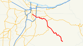
Oregon Route 224 is a state highway which runs through some of Portland's southeastern suburbs and ends in the Cascades.
Route description
The northwestern terminus is an interchange with OR 99E in Milwaukie, a suburb of Portland. It continues east as the Milwaukie Expressway, but is formally part of the Clackamas Highway No. 171 (see Oregon highways and routes), until it reaches Interstate 205 in Clackamas, where traffic is directed along the interstate for less than a mile. The concurrency with Interstate 205 is part of the East Portland Freeway No. 64. Then, the highway continues east as a four-lane arterial, resuming its designation as the Clackamas Highway, and which it shares with OR 212. East of Clackamas, OR 224 splits off OR 212, and continues south as the Clackamas Highway, passing through hilly farmland. About eight miles (13 km) north of Estacada, it overlaps OR 211. On the eastern edge of Estacada, OR 224 separates from OR 211, and heads southeast into the Mount Hood National Forest, to the small community of Ripplebrook, its southeastern terminus, where state highway maintenance ends. Drivers may continue along the paved United States Forest Service Road 46 to OR 22 in Detroit, though snow makes the road impassable approximately early November through early May. USFS Road 46 was formerly signed as a portion of OR 224, but was never a state-maintained highway.
History
This is the 2nd route in Oregon with the designation 224. There was an earlier version of OR 224 connecting US 99W (modern Oregon Route 99W) 3 miles (5 km) south of Monmouth to Oregon Route 223 near Lewisville following today's Elkins Rd. In those days, Oregon Route 223 followed today's Airlie Rd and Maple Grove Rd between Falls City and Pedee). This incarnation of OR 224 existed from the inception of the Oregon Route System in 1932 until sometime between 1942 and 1944.
Sunrise Expressway
The Sunrise Expressway (known as Sunrise Corridor during construction) is a limited-access highway in Clackamas. It serves as an extension of the Milwaukie Expressway portion of OR 224. Planning for the expressway started in the 1980s. Plans weren't approved until 2010, with construction starting in 2013. Costing $130 million, the expressway opened on July 1, 2016. A multi-use path for use by bicyclists and pedestrians was constructed along the highway. It is the newest highway constructed in the Portland metropolitan area since OR 213 bypassed Oregon City in 1989.[1]
Major intersections
Mileposts do not reflect actual mileage due to realignments. The entire route is in Clackamas County.
| Location | mi[2] | km | Destinations | Notes | |
|---|---|---|---|---|---|
| Milwaukie | 0.11 | 0.18 | Interchange | ||
| 2.42 | 3.89 | Lake Road, Harmony Road | Interchange | ||
| Clackamas | 3.88 | 6.24 | Interchange; west end of OR 213 overlap | ||
| 4.44 | 7.15 | Interchange; west end of I-205 overlap | |||
| 4.93 | 7.93 | Interchange; east end of I-205 and OR 213 overlap; west end of OR 212 overlap | |||
| Damascus | 8.19 | 13.18 | East end of OR 212 overlap | ||
| Eagle Creek | 17.92 | 28.84 | West end of OR 211 overlap | ||
| Estacada | 23.36 | 37.59 | East end of OR 211 overlap | ||
| Ripplebrook | 49.97 | 80.42 | |||
1.000 mi = 1.609 km; 1.000 km = 0.621 mi
| |||||
References
- ↑ Njus, Elliot (June 30, 2016). "First new Portland-area highway in nearly 3 decades to open in Clackamas". The Oregonian. Portland, OR. Retrieved June 30, 2016.
- ↑ "Clackamas Highway No. 171 Straightline Chart" (PDF). Oregon Department of Transportation. Retrieved January 26, 2014.
