Oleśnica
| Oleśnica | |||
|---|---|---|---|
|
| |||
| |||
|
Motto: Miasto wież i róż "A Town of Towers and Roses" | |||
 Oleśnica | |||
| Coordinates: 51°12′N 17°23′E / 51.200°N 17.383°E | |||
| Country |
| ||
| Voivodeship | Lower Silesian | ||
| County | Oleśnica County | ||
| Gmina | Oleśnica (urban gmina) | ||
| Established | 13th century | ||
| Town rights | 1255 | ||
| Government | |||
| • Mayor | Michał Wincenty Kołaciński | ||
| Area | |||
| • Total | 20.96 km2 (8.09 sq mi) | ||
| Elevation | 150 m (490 ft) | ||
| Population (2006) | |||
| • Total | 36,951 | ||
| • Density | 1,800/km2 (4,600/sq mi) | ||
| Time zone | CET (UTC+1) | ||
| • Summer (DST) | CEST (UTC+2) | ||
| Postal code | 56-400 | ||
| Area code(s) | +48 71 | ||
| Car plates | DOL | ||
| Website | http://www.olesnica.pl | ||
Oleśnica [ɔlɛɕˈɲit͡sa] (German: Oels) is a town in Lower Silesian Voivodeship, in south-western Poland. From 1975–1998 it was in former Wrocław Voivodeship. It is the administrative seat of Oleśnica County and also of the rural district of Gmina Oleśnica, although it is not part of the territory of the latter, the town being an urban gmina in its own right.
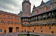
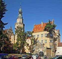
The town is famed for its large 16th-century castle, which has previously been the seat of dukes and lords. The castle's inner courtyard arcades, a masterpiece of Renaissance architecture, are iconic in the region.
Name
The town's name comes from Polish olsza ("Alder"); Olcha is an Old Slavic word for this common plant and tree.[1][2] On 22 February 1255 the Silesian duke Henry III the White, son of the Polish High Duke Henry II the Pious, vested civitas nostra Olsnicz ("our town Oleśnica") with town privileges.[3]
Geography
The town is situated in the Silesian Lowlands east of the Trzebnickie Hills, part of the historical region of Lower Silesia. Located about 30 kilometres (19 mi) northeast of the Silesian capital Wrocław, it has been a stop on an important trade route to the Greater Poland region, Kalisz, Łódź and Warsaw; it had close ties with Kraków via Namysłów in the east. It was the site of an important printing press and gymnasium. From the 13th century, it had a coin mint.
The town quarters are Centrum, Serbinów, Lucień, Lucień Osiedle, Wądoły, Rataje (Stare, Nowe) and Zielone Ogrody.
History
The Piast castle with a nearby abbey and trading settlement was first mentioned in an 1189 deed. From the 13th century onwards, the area was largely settled by Germans in the course of the Ostsiedlung.[4] From 1320/21 the former castellany served as the residence of the Piast duke Konrad I of Oleśnica; his son Duke Konrad II the Gray also inherited Koźle. The Duchy of Oleśnica, a Bohemian fief since 1327, was ruled from the town until the 1492 death of Duke Konrad X the White, last of the local Piasts.

.jpg)
The duchy was sold to Duke Henry I of Münsterberg, son of the Bohemian king George of Poděbrady. His grandson Duke John of Münsterberg-Oels established a gymnasium at Oels in 1530. When the Podiebrad family became extinct in 1647, town and duchy were inherited by the Swabian dukes of Württemberg, and in 1792 by the Welf dukes of Brunswick-Lüneburg.
As Oels, the town was annexed by the Kingdom of Prussia in 1742 during the First Silesian War and administered within the Province of Silesia. Following administrative reform in 1807 during the Napoleonic Wars, Oels became the seat of Landkreis Oels. The city became part of the German Empire in 1871 during the Prussian-led unification of Germany.
After World War I, Oels was included within the Province of Lower Silesia. It was heavily damaged by the Red Army in 1945 during World War II, having approximately 60-80% of its buildings destroyed. The city was placed in Poland's borders after the Potsdam Conference and its official name became Oleśnica. The remaining German-speaking population was subsequently expelled and resettled with Poles many of whom were expelled from Eastern Poland annexed in 1945 by the Soviet Union. Several monuments of the former residence have been rebuilt since the 1960s.
Notable people
- Joachim of Münsterberg-Oels (1503–1562), Duke of Münsterberg and from 1536 to 1542 also Duke of Oels
- Hedwig of Münsterberg-Oels (1508–1531), Margravine of Brandenburg-Ansbach-Kulmbach
- John, Duke of Münsterberg-Oels (1509–1565), Duke of the Münsterberg from 1542 to 1565, Duke of Oels from 1548 to 1565 and Duke of Bernstadt from 1548 to 1565
- George II, Duke of Münsterberg-Oels (1512–1553), Duke of Münsterberg 1536-1542 and Duke of Oels
- Henry III, Duke of Münsterberg-Oels (1542–1587), Duke of Münsterberg from 1565 to 1574 and Duke of Bernstadt
- Karl II, Duke of Münsterberg-Oels (1545–1617), Duke of Oels from 1565 to 1617 and Duke of Bernstadt from 1604 to 1617
- Karl Christoph, Duke of Münsterberg (1545–1569), Duke of Münsterberg from 1565 to 1569
- Henry Wenceslaus, Duke of Oels-Bernstadt (1592–1639)
- Abraham von Franckenberg (1593–1652), mystic, born in nearby Bystre
- Karl Friedrich I, Duke of Münsterberg-Oels (1593–1647), Duke of Oels from 1617 to 1647 and Duke of Bernstadt from 1639 to 1647
- Elisabeth Marie, Duchess of Oels (1625–1686), German noblewoman
- Christian Ulrich I, Duke of Württemberg-Oels (1652–1704), German nobleman, Duke of Württemberg-Bernstadt from 1669 to 1697 and Duke of Oels-Württemberg from 1697 until his death
- Julius Siegmund, Duke of Württemberg-Juliusburg (1653–1684), was Duke of Württemberg-Juliusburg
- Eugen of Württemberg (1788-1857), general
- Carl Heinrich Zöllner (1792–1836), German composer
- Julius Hübner (1806–1882), painter
- Gustav Becker (1819-1885), clockmaker
- Willy Hellpach (1877-1955), physicist and politician
- Antoni Cieszyński (1882–1941), surgeon
- Werner Krolikowski (born 1928), East German political
- Otto Laske (born 1936, composer, lyric poet, visual artist
- Sigmar Polke (1941–2010), artist
- Piotr Czech (born 1986), kicker for Pittsburgh Steelers
- Wojciech Bartnik (born 1967), boxer, Olympic bronze medallist
- Kasia Glowicka (born 1977), composer
- Jerzy Rogalski (born 1948), film and theatre actor
Twin towns
Oleśnica is twinned with:
References
- ↑ www.poradniajezykowa.us.edu.pl
- ↑ www.olesnica.pl
- ↑ http://alo.uibk.ac.at/webinterface/library/ALO-BOOK_V01?objid=19012 page 333
- ↑ Eberl, Immo (1993). Immo Eberl, Ministry for Internal Affairs, Baden-Württemberg (Germany), eds. Flucht, Vertreibung, Eingliederung (in German). Thorbecke. p. 26. ISBN 3-7995-2500-9.
External links
| Wikimedia Commons has media related to Oleśnica. |
| Wikisource has the text of the 1905 New International Encyclopedia article Öls. |
- Municipal website
- Panorama Oleśnicka (in Polish)
- News from Oleśnica (in Polish)
- History of Oleśnica (in Polish)
- Old postcards from Oleśnica (in Polish)
- Jewish Community in Oleśnica on Virtual Shtetl
- Ads and News from Oleśnica (in Polish)
Coordinates: 51°12′N 17°23′E / 51.200°N 17.383°E


