Ohio State Route 533
| ||||
|---|---|---|---|---|
|
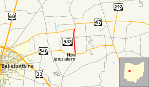
Map of SR 533 c. 2013 | ||||
| Route information | ||||
| Maintained by ODOT | ||||
| Length: | 1.80 mi[1] (2.90 km) | |||
| Existed: | 1937 – 2014 | |||
| Major junctions | ||||
| South end: |
| |||
| North end: |
| |||
| Location | ||||
| Counties: | Logan | |||
| Highway system | ||||
| ||||
State Route 533 (SR 533) was a short two-lane north–south state highway in west central Ohio. Existing entirely within Jefferson Township, Logan County, and to the northeast of the county seat of Bellefontaine, SR 533 ran a distance of 1.8 miles (2.9 km) between SR 540 and SR 47 near the campus of Benjamin Logan Local School District. The entire route was turned over by the Ohio Department of Transportation (ODOT) to Logan County jurisdiction by 2014.
Route description
SR 533 commenced at an intersection approximately 4 miles (6.4 km) east of Bellefontaine where the western and southern legs are formed by SR 540. Following the route of County Road 5 northerly through the farmlands of Logan County's Jefferson Township, SR 533 had one intersection, Jefferson Township Road 127, en route to its endpoint at its junction with SR 47 at a T-intersection near the Benjamin Logan Local School District campus.[2]
History
SR 533 was designated in 1937 along the routing that it occupied until 2014.[3][4] The entire road was asphalt-paved by 1940.[5][6] In the winter of 2013/2014, ODOT and the Logan County Engineer arranged a swap of roads within Logan County. All of SR 533 was re-signed as "OLD 533" and Logan County Road 5 (with which State Route 533 was already entirely concurrent with) while County Roads 144 and 144A in the southeastern part of the county became state-maintained as an extension of SR 347.[7] Signs designating the extended county road and its status as Old SR 533 have been posted on the former state route.[7][8][9]
Major intersections
The entire route was in Jefferson Township, Logan County.
| mi[1] | km | Destinations | Notes | ||
|---|---|---|---|---|---|
| 0.00 | 0.00 | ||||
| 1.80 | 2.90 | ||||
| 1.000 mi = 1.609 km; 1.000 km = 0.621 mi | |||||
References
- 1 2 "DESTAPE - Logan County" (PDF). Ohio Department of Transportation. July 16, 2013. Archived from the original (PDF) on July 26, 2014. Retrieved November 1, 2015.
- ↑ Google (November 1, 2015). "Ohio State Route 533" (Map). Google Maps. Google. Retrieved November 1, 2015.
- ↑ Ohio State Map (Map). Ohio Department of Transportation. 1936.
- ↑ Ohio State Map (Map). Ohio Department of Transportation. 1937.
- ↑ Ohio Highway Map 1939 (MrSID) (Map). Cartography by Robt. S. Beightler, Director. Ohio Department of Highways. 1939. Retrieved August 19, 2013.
- ↑ Ohio Highway Map 1940 (MrSID) (Map). Cartography by Robt. S. Beightler, Director. Ohio Department of Highways. 1940. Retrieved August 18, 2013.
- 1 2 "The Orange Brigade" (PDF) (Winter 2014 ed.). Logan County Engineer's Office. 2014. p. 5. Archived from the original (PDF) on August 13, 2014. Retrieved November 1, 2015.
- ↑ Google (September 26, 2014). "StreetView image showing an Old SR 533 sign at SR 540" (Map). Google Maps. Google. Retrieved September 26, 2014.
- ↑ Google (September 26, 2014). "StreetView image showing an Old SR 533 sign at SR 47" (Map). Google Maps. Google. Retrieved September 26, 2014.
External links
Route map: Google

