Numaligarh
| Numaligarh নুমলীগড় | |
|---|---|
| town | |
 Numaligarh  Numaligarh Location in Assam, India | |
| Coordinates: 26°38′N 93°45′E / 26.633°N 93.750°ECoordinates: 26°38′N 93°45′E / 26.633°N 93.750°E | |
| Country |
|
| State | Assam |
| District | Golaghat |
| Languages | |
| • Official | Assamese Hindi English |
| Time zone | IST (UTC+5:30) |
| Pin Cord | 785615 |
| ISO 3166 code | IN-AS |
| Vehicle registration | AS 05 |
Numaligarh is a town in the Golaghat district of Assam, India. It is situated at a distance of 32 km from Golaghat town, 265 km from Guwahati, 6 km from Morangi and 51 km from Jorhat.
History
Historically it is associated with both Kachari and Ahom kingdom. After Ahom king Suhungmung annexed Numaligarh, he started to live with Kachari princess Numali and built a "garh" (fortification) around the place where they lived. However, only remains of that "garh" is found now.
Tourism attractions
A few kilometers away from Numaligarh, the Babathan named a Shiv Temple is situated.The Dhanshiri River passes through the city.There is a butterfly garden in Numaligarh also.
Numaligarh Refinery
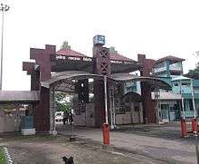
A petroleum refinery named Numaligarh Refinery Limited Limited has been established in 2001. Numaligarh Refinery Limited is one of the major refineries of north east, having a capacity of 3 MMT. Numaligarh Refinery Limited is a joint venture of Assam Government (12.35%) owned Numaligarh Refinery Limited with Bharat Petroleum Corporation Limited (61.65%),Oil India Limited (26%)
Transport
The National Highway 715 (India) Known as NH 37(old name) and National Highway 129 (India) known as NH 39(old name) passes through Numaligarh. It has a bus stop but no any Government bus Station.The nearest railway station is in Golaghat and the nearest airport is in Jorhat.
References
Vardika Jallan-Malkin of numaligarh