Novyi Svit
| Novyi Svit Новий Світ — Новый Свет | |||
|---|---|---|---|
| Urban-type settlement | |||
|
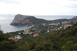
Novyi Svit seen from the north-eastern part of town. | |||
| |||
.svg.png) Novyi Svit Location of Novyi Svit on a map of Crimea. | |||
| Coordinates: 44°49′45″N 34°54′46″E / 44.82917°N 34.91278°ECoordinates: 44°49′45″N 34°54′46″E / 44.82917°N 34.91278°E | |||
| Country | Russia/Ukraine[1] | ||
| Republic | Crimea | ||
| Municipality | Sudak Municipality | ||
| Elevation | 50 m (160 ft) | ||
| Population (2014) | |||
| • Total | 1,248 | ||
| Time zone | MSK (UTC+4) | ||
| Postal code | 98032 | ||
| Area code(s) | +380 6566 | ||
| Website | Verkhovna Rada of Ukraine | ||
Novyi Svit (Ukrainian: Новий Світ, Novyi Svit; Russian: Но́вый Свет, tr. Novy Svet; Crimean Tatar: Novıy Svet; literally: 'New World' or more correctly 'New Community') is a resort, an urban-type settlement in Sudak Municipality in the Autonomous Republic of Crimea, a territory recognized by a majority of countries as part of Ukraine and incorporated by Russia as the Republic of Crimea. It is known for Novyi Svit sparkling wine produced there. Champagne production was introduced into Novyi Svit by a local landowner, Prince Lev Golitsyn, in the late 19th century. Population: 1,248 (2014 Census).[2]
The town is situated in a very scenic area where numerous Soviet movies were filmed. It boasts some fine beaches, a couple of resort hotels (one of which was supposed to be for Soviet cosmonauts), a several km tunnel inside a mountain where a factory stores its products, and a large juniper forest.
 A Juniper forest in Novyi Svit
 Golycinskaya path
 Muzikal'niy cave
 Wine storage in Novyi
References
- ↑ This place is located on the Crimean Peninsula, most of which is the subject of a territorial dispute between Russia and Ukraine. According to the political division of Russia, there are federal subjects of the Russian Federation (the Republic of Crimea and the federal city of Sevastopol) located on the peninsula. According to the administrative-territorial division of Ukraine, there are the Ukrainian divisions (the Autonomous Republic of Crimea and the city with special status of Sevastopol) located on the peninsula.
- ↑ Russian Federal State Statistics Service (2014). "Таблица 1.3. Численность населения Крымского федерального округа, городских округов, муниципальных районов, городских и сельских поселений" [Table 1.3. Population of Crimean Federal District, Its Urban Okrugs, Municipal Districts, Urban and Rural Settlements]. Федеральное статистическое наблюдение «Перепись населения в Крымском федеральном округе». ("Population Census in Crimean Federal District" Federal Statistical Examination) (in Russian). Federal State Statistics Service. Retrieved January 4, 2016.
External links
-
 Media related to Category:Noviy Svet at Wikimedia Commons

.png)
