Nor'Wester Mountains
| Nor'Wester Mountains | |
|---|---|
|
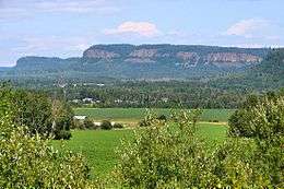
The Nor'Westers seen from Neebing Township | |
| Highest point | |
| Peak | Mount McKay |
| Elevation | 483 m (1,585 ft) |
| Coordinates | 48°20′43″N 89°17′8″W / 48.34528°N 89.28556°WCoordinates: 48°20′43″N 89°17′8″W / 48.34528°N 89.28556°W |
| Geography | |
| Country | Canada |
| Province | Ontario |

Mount McKay
The Nor'Wester Mountains are a group of mountains immediately south of Thunder Bay, Ontario, Canada, located on the southern limits of the City of Thunder Bay and south of the Kaministiquia River.[1]:32,33 Mount McKay is the highest, most northern and best known of these mountains. Other prominent peaks include Godfrey, Hurlburt, Johnson, Matchett, McRae, McQuaig, Rose, and Squaretop.
Loch Lomond, 287 m (942 ft) above sea level, collects most of the runoff within the Nor’Wester Mountains; Loch Lomond is drained by the Lomond River.[1]:5 A few square kilometers of mountain slope south of Mount McKay are drained by Whiskeyjack Creek.[1]:5
References
- 1 2 3 Watershed Characterization Report Lakehead Source Protection Area (PDF) (Report). Source Water Protection–Lakehead Region. March 2008. Retrieved June 14, 2010.
External links
This article is issued from
Wikipedia.
The text is licensed under Creative Commons - Attribution - Sharealike.
Additional terms may apply for the media files.