Nochistlán de Mejía Municipality
| Nochistlán de Mejía Nochistlán | ||
|---|---|---|
| Municipality | ||
| ||
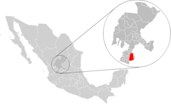
 Location of Nochistlán within Zacatecas and Mexico | ||
| Coordinates: 21°48′03″N 102°45′57″W / 21.80083°N 102.76583°W | ||
| Country |
| |
| State |
| |
| Municipal seat | Nochistlán de Mejía | |
| Largest city | Nochistlán | |
| Villa de Guadalajara (When settled by Spaniards) | December 3, 1531[1] | |
| Founded Municipality | 1825 | |
| Heroic defense against the French | May 13, 1864 | |
| Government | ||
| • Type | Ayuntamiento | |
| • Municipal President | Profr. Armando Delgadillo Ruvalcaba | |
| Area | ||
| • Total | 877.05 km2 (338.63 sq mi) | |
| Population (2010) | ||
| • Total | 27,932 | |
| • Density | 31.8/km2 (82/sq mi) | |
| • Largest city | 16,562 | |
| Time zone | CST (UTC-6) | |
| Postal Code | 99900-99919 | |
| Area code(s) | 346 | |
| Website |
www | |
Nochistlán is one of the 58 municipalities in the Mexican state of Zacatecas. Founded by the Caxcanes, it was also the first site of Guadalajara in Mexico.
Population
In the 2005 census, the Municipality of Nochistlán reported a population of 26,195.[2] Of these, 16,562 lived in the municipal seat, Nochistlán, and the remainder lived in surrounding rural communities.
History
The first news that we have regarding the natives of these lands points to the Tecuexes. These people settled in the region around 1000 A.D. Later, in the 12th century, a new group of people called the Caxcanes moved in, they were from the valley in Tuitlán, which is now found in the Municipality of Villanueva, Zacatecas. The Caxcanes established Nochistlán by driving out the Tecuexes by force.
On December 3, 1531, Nuño Beltrán de Guzmán hired Cristobal de Oñate to establish a village in Nochistlán, (now a town in Zacatecas) the village would be named Guadalajara in honor of Guzmán for his birth in Guadalajara. Guadalajara was founded in Nochistlán on January 5, having as officials Oñate, Sancho Ortiz de Zuñiga and Miguel de Ibarra. They worked at this project for only 16 months and created the first layout of Guadalajara.
Location
- Latitude - 21°48'03" N
- Longitude - 102°45'57" W
- Population 26,195
Coordinates: 21°48′N 102°46′W / 21.800°N 102.767°W
References
- ↑ Nochistlán Website's History Page
- ↑ Link to tables of population data from Census of 2005 Archived 2013-02-27 at WebCite INEGI: Instituto Nacional de Estadística, Geografía e Informática

