Newton Heath railway station
| Newton Heath | |
|---|---|
|
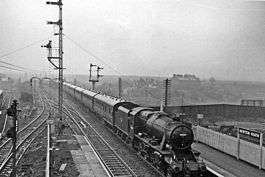
Westbound empty stock train in 1962 | |
| Location | |
| Place | Newton Heath |
| Area | City of Manchester |
| Grid reference | SD877011 |
| Operations | |
| Original company | Lancashire and Yorkshire Railway |
| Pre-grouping | Lancashire and Yorkshire Railway |
| Post-grouping | London, Midland and Scottish Railway |
| Platforms | 2 |
| History | |
| 1 December 1853 | Opened |
| 3 January 1966 | Closed [1] |
| Disused railway stations in the United Kingdom | |
|
Closed railway stations in Britain A B C D–F G H–J K–L M–O P–R S T–V W–Z | |
|
| |
Newton Heath Railway Station served the district of Newton Heath in east Manchester. It was opened by the Lancashire and Yorkshire Railway (LYR) on 1 December 1853 and was closed by British Railways on 3 January 1966. The station buildings were situated on the northwest side of Dean Lane, where that road passed over the LYR line from Manchester Victoria to Rochdale, and 300 yards north of Dean Lane. It was immediately adjacent to the large LYR Newton Heath steam locomotive shed. The area is now served by Newton Heath and Moston Metrolink station, which opened on 28 February 2013.
References
- The Oldham Loop by Jeffrey Wells (ISBN 1-870119-76-2)
- The Manchester and Leeds Railway by Martin Bairstow
- The Directory of Railway Stations by R.V.J. Butt, PSL, 1995 (ISBN 1-85260-508-1)
| Preceding station | Disused railways | Following station | ||
|---|---|---|---|---|
| Miles Platting | Lancashire and Yorkshire Railway | Moston | ||
| Manchester Lines | |||||||||||||||||||||||||||||||||||||||||||||||||||||||||||||||||||||||||||||||||||||||||||||||||||||||||||||||||||||||||||||||||||||||||||||||||||||||||||||||||||||||||||||||||||||||||||||||||||||||||||||||||||||||||||||||||||||||||||||||||||||||||||||||||||||||||||||||||||||||||||||||||||||||||||||||||||||||||||||||||||||||||||||||||||||||||||||||||||||||||||||||||||||||||||||||||||||||||||||||||||||||||||||
|---|---|---|---|---|---|---|---|---|---|---|---|---|---|---|---|---|---|---|---|---|---|---|---|---|---|---|---|---|---|---|---|---|---|---|---|---|---|---|---|---|---|---|---|---|---|---|---|---|---|---|---|---|---|---|---|---|---|---|---|---|---|---|---|---|---|---|---|---|---|---|---|---|---|---|---|---|---|---|---|---|---|---|---|---|---|---|---|---|---|---|---|---|---|---|---|---|---|---|---|---|---|---|---|---|---|---|---|---|---|---|---|---|---|---|---|---|---|---|---|---|---|---|---|---|---|---|---|---|---|---|---|---|---|---|---|---|---|---|---|---|---|---|---|---|---|---|---|---|---|---|---|---|---|---|---|---|---|---|---|---|---|---|---|---|---|---|---|---|---|---|---|---|---|---|---|---|---|---|---|---|---|---|---|---|---|---|---|---|---|---|---|---|---|---|---|---|---|---|---|---|---|---|---|---|---|---|---|---|---|---|---|---|---|---|---|---|---|---|---|---|---|---|---|---|---|---|---|---|---|---|---|---|---|---|---|---|---|---|---|---|---|---|---|---|---|---|---|---|---|---|---|---|---|---|---|---|---|---|---|---|---|---|---|---|---|---|---|---|---|---|---|---|---|---|---|---|---|---|---|---|---|---|---|---|---|---|---|---|---|---|---|---|---|---|---|---|---|---|---|---|---|---|---|---|---|---|---|---|---|---|---|---|---|---|---|---|---|---|---|---|---|---|---|---|---|---|---|---|---|---|---|---|---|---|---|---|---|---|---|---|---|---|---|---|---|---|---|---|---|---|---|---|---|---|---|---|---|---|---|---|---|---|---|---|---|---|---|---|---|---|---|---|---|---|---|---|---|---|---|---|---|---|---|---|---|---|---|---|---|---|---|---|---|---|---|---|---|---|---|---|---|---|---|---|---|---|---|---|---|---|---|---|---|
| |||||||||||||||||||||||||||||||||||||||||||||||||||||||||||||||||||||||||||||||||||||||||||||||||||||||||||||||||||||||||||||||||||||||||||||||||||||||||||||||||||||||||||||||||||||||||||||||||||||||||||||||||||||||||||||||||||||||||||||||||||||||||||||||||||||||||||||||||||||||||||||||||||||||||||||||||||||||||||||||||||||||||||||||||||||||||||||||||||||||||||||||||||||||||||||||||||||||||||||||||||||||||||||
Coordinates: 53°30′22″N 2°11′10″W / 53.5062°N 2.1862°W
This article is issued from
Wikipedia.
The text is licensed under Creative Commons - Attribution - Sharealike.
Additional terms may apply for the media files.
