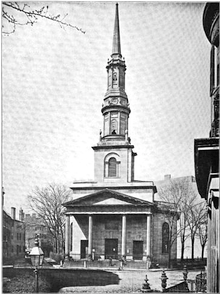
New South Church (Boston, Massachusetts)

New South Church (1714-1866) was a congregational unitarian church of the "New South Society" in Boston, Massachusetts, located on "Church Green" at the corner of Summer Street and Bedford Street. Pastors included Samuel Checkley and John Thornton Kirkland. In 1814 architect Charles Bulfinch designed a new building for the society; it was demolished in 1868. The congregation merged with the New South Free Church in 1866.
History
1714-1814
Founders of the New South Church first met around 1714 at the "old Bull Tavern, at the corner of Summer and Sea Streets."[1][2]
In 1715, the town of Boston deeded a parcel of land (65 by 45 feet (20 m × 14 m)) with a harbor view "to petitioners who proposed to build a church ... to be called the 'New South.' The father of Samuel Adams ... lived on Purchase Street, near Congress, and was one of the signers of the petition." Among the 44 initial subscribers were Samuel Adams, Sr.; John Barton; Nicholas Boon; David Craige; Eleaz. Dorby; William Engs; Samuel Greenleaf; Henry Hill; Daniel Legre; Thomas Peck; Eneas Salter; Eneas Salter Jr.; Thomas Salter; Jonathan Simpson.[3][4]
The new building was completed by 1719. It was "a convenient wooden building with a handsome steeple finished after the lonick order, in which is a bell."[5] "It was of timber, 65 by 45 by 31 feet, with flat roof and battlements."[6] Samuel Checkley was ordained as first pastor on April 15, 1719. "The covenant was signed on the same day" by several of the original subscribers, as well as Samuel Bridgham, John Clough, Thomas Downe, and Benjamin White.[3]
1814-1868
In 1814 a new building was constructed, designed by Charles Bulfinch, at a cost of 2,188 pounds.[7] It was built out of Chelmsford granite. "The first story of the steeple is an octagon, surrounded by 8 columns and a circular pedestal and entablature; an attic, above this, gradually diminishing by 3 steps of gradins, supports a second range of Corinthian columns with an entablature and balustrade from this, the ascent in a gradual diminution, forms the base of the spire, which is crowned with a ball and vane."[8] In the first half of the 19th century "Summer Street was, beyond dispute, the most beautiful avenue in Boston. Magnificent trees then skirted its entire length, overarching the driveway with interlacing branches, so that you walked or rode as within a grove in a light softened by the leafy screen" of elms.[1] Inside the church, the organ was built by Thomas Appleton.[9]
In 1866, the church "was merged in the New South Free Church."[10] The New South Society's William Tilden served as pastor there for several decades.[11] The building was demolished in 1868.[12] Today the former site of the Church Green is known as the Church Green Buildings Historic District.
Pastors
- Samuel Checkley (pastor 1719-1769; d.1769)
- Penuel Bowen (pastor 1766-1772)
- Joseph Howe (pastor 1773-1775; d.1775)
- Oliver Everett (pastor 1782-1792)
- John Thornton Kirkland (pastor 1794-1810)
- Samuel Cooper Thacher (pastor 1811-1818; d.1818)
- F.W.P. Greenwood (pastor 1818-1821)
- Alexander Young (pastor 1825-1854; d.1854)
- Orville Dewey (pastor 1857-1862)
- William P. Tilden (pastor 1862-1866)[2]
References
- 1 2 Drake. Old landmarks and historic personages of Boston. 1873
- 1 2 George Edward Ellis. A commemorative discourse delivered in the New South Church: Church Green, Boston, on Sunday, December 25, 1864, on the fiftieth anniversary of its dedication. Boston: Henry Dutton and Son, 1865.
- 1 2 Snow. History of Boston. 1828; p.213.
- ↑ Records relating to the early history of Boston. 1881.
- ↑ Albert William Mann. Walks & talks about historic Boston. 1917; p.539.
- ↑ Thwing. Crooked & narrow streets of the town of Boston 1630-1822. 1920; p.184.
- ↑ Charles A. Place. The New South Church, Boston, Mass. Old-Time New England, v.11, no.2. Oct. 1920
- ↑ Charles Shaw, 1817; quoted in Place. 1920; p.52.
- ↑ (The Appleton organ eventually was reinstalled first in a Baptist church in Providence, RI; and then in 1872 in the New Old South Church in Back Bay.) Henry C. Lahee. Organs and organ building in New England. New England magazine, Volume 17, 1897; p.492.
- ↑ Windsor. Memorial history of Boston. 1882; p.480.
- ↑ Boston almanac. 1883.
- ↑ Sale of Church Property. New York Times, April 10, 1868, p.5.
Further reading
| Wikimedia Commons has media related to New South Church (Boston, Massachusetts). |
- Church Green service book. 1863.
- "New South Society." Monthly Journal of the American Unitarian Association, v.8, no.10. Nov. 1867.
- An act concerning the proprietors of the New South Meeting-House in Boston, and the disposition of their estate. Acts and resolves passed by the General Court of Massachusetts. 1868.
- Ellen Susan Bulfinch. Life and Letters of Charles Bulfinch, Architect. Houghton, Mifflin & Co., Boston and New York 1896.
- Museum of Fine Arts Bulletin, v.10, no.59, 1912.
Coordinates: 42°21′12.41″N 71°3′28.62″W / 42.3534472°N 71.0579500°W