New Hampshire Route 102
| ||||
|---|---|---|---|---|
|
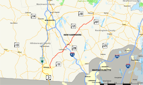
Map of southern New Hampshire with NH 102 highlighted in red | ||||
| Route information | ||||
| Maintained by NHDOT | ||||
| Length: | 23.956 mi[1] (38.553 km) | |||
| Major junctions | ||||
| West end: |
| |||
|
| ||||
| East end: |
| |||
| Location | ||||
| Counties: | Hillsborough, Rockingham | |||
| Highway system | ||||
| ||||
New Hampshire Route 102 (abbreviated NH 102) is a 23.956-mile-long (38.553 km) state highway in Rockingham and Hillsborough counties in the southern part of the U.S. state of New Hampshire. NH 102 runs southwest to northeast between Hudson and Raymond, but is signed as an east–west route.
Some confusion exists over the western terminus. The state route logs show that the end of the road is at the junction with Ferry Street (New Hampshire Route 111) in Hudson. Local signage shows NH 102 continuing along NH 111 as a concurrency over the Hudson Bridge into Nashua. Signage on the bridge indicates NH 102 sharing East Hollis Street with NH 111.
The eastern terminus of NH 102 is in Raymond at New Hampshire Route 107, a short distance south of New Hampshire Route 101. Exit signs on NH 101 indicate 102 at the exit, but officially the road ends at NH 107.
Route description
The route starts in Hudson at Route 111 (Ferry Street) and Route 3A (Chase Street). This starts a concurrency with Route 3A.[2]
Major intersections
| County | Location[1][3] | mi[1][3] | km | Destinations | Notes |
|---|---|---|---|---|---|
| Hillsborough | Hudson | 0.000 | 0.000 | Western terminus; western end of concurrency with NH 3A | |
| 1.008 | 1.622 | Eastern end of concurrency with NH 3A | |||
| Rockingham | Londonderry | 7.665 | 12.336 | ||
| 9.368– 9.776 | 15.076– 15.733 | Exit 4 on I-93 | |||
| Derry | 10.857 | 17.473 | |||
| 11.798 | 18.987 | Danforth Circle[1] | |||
| Chester | 17.248 | 27.758 | |||
| Raymond | 23.956 | 38.553 | Eastern terminus | ||
1.000 mi = 1.609 km; 1.000 km = 0.621 mi
| |||||
References
- 1 2 3 4 Bureau of Planning & Community Assistance (February 20, 2015). "NH Public Roads". Concord, New Hampshire: New Hampshire Department of Transportation. Retrieved April 7, 2015.
- ↑ Google (1 June 2014). "Start of NH 102" (Map). Google Maps. Google. Retrieved 1 June 2014.
- 1 2 Bureau of Planning & Community Assistance (April 3, 2015). "Nodal Reference 2015, State of New Hampshire". New Hampshire Department of Transportation. Retrieved April 7, 2015.

