Rhineland Nature Park

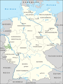
location map

Kottenforst station within the park
Rheinland Nature Park (Naturpark Rheinland) is a nature park in North Rhine-Westphalia, situated between Bergheim, Kerpen, Erftstadt, Euskirchen, Königswinter, Bornheim, Bonn, Brühl, Hürth, Frechen and Pulheim. It covers an area of about 880 km².
Ville-Seen-Platte
Roughly translated, this would be the 'plateau of lakes in the Ville'.
In the vicinity of Erftstadt, Brühl and Hürth many small and large lakes have been created due to coal mining. The reforestation of the area was begun in 1920 by planting beech, pine, oak and larch trees. Today, there are about forty lakes that have sprung from the mining operations.
List of lakes on the Villen-Seen-Platte:
- Concordia See
- Köttinger See
- Zieselsmaarsee
- Villesee
- Dinnendahlsee
- Liblarer See
- Forellenteich
- Obersee
- Mittelsee
- Untersee
- Bleibtreusee
- Silbersee
- Heider Bergsee
- Gruhlsee
- Margarethenweier
- Schluchtsee
- Franziskussee
- Karauschenweiher
- Teich
- Donatussee
- Zwillingssee
- Entenweiher
- Villenhofer Maar
- Pfingsdorfer See
- Fasanenweiher
- Forsthausweiher
- Lucretiasee
- Berggeistsee
- Gotteshülfeteich
- Otto-Maiglersee
- Waldsee
- Klärteich
External links
| Wikimedia Commons has media related to Naturpark Rheinland. |
- Naturpark Rheinland (German)
Coordinates: 50°49′10″N 6°51′10″E / 50.81944°N 6.85278°E
This article is issued from
Wikipedia.
The text is licensed under Creative Commons - Attribution - Sharealike.
Additional terms may apply for the media files.