National Register of Historic Places listings in Van Buren County, Arkansas

Location of Van Buren County in Arkansas
This is a list of the National Register of Historic Places listings in Van Buren County, Arkansas.
This is intended to be a complete list of the properties and districts on the National Register of Historic Places in Van Buren County, Arkansas, United States. The locations of National Register properties and districts for which the latitude and longitude coordinates are included below, may be seen in a map.[1]
There are 16 properties and districts listed on the National Register in the county.
Contents: Counties in Arkansas
|
|
- This National Park Service list is complete through NPS recent listings posted July 14, 2017.[2]
Current listings
| [3] |
Name on the Register[4] |
Image |
Date listed[5] |
Location |
City or town |
Description |
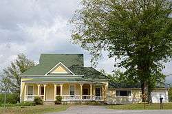
|---|
| 1 |
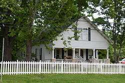
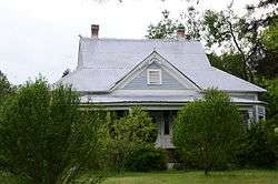
Melvin Chrisco House |
|
000000002005-09-28-0000September 28, 2005
(#05001082) |
237 Alvin Brown Rd.
35°22′13″N 92°25′22″W / 35.370278°N 92.422778°W / 35.370278; -92.422778 (Melvin Chrisco House) |
Damascus |
|
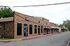
| 2 |
Clinton Commercial Historic District |
|
000000002006-05-15-0000May 15, 2006
(#06000410) |
Roughly bounded by Town Branch Creek and by U.S. Highway 65B
35°35′43″N 92°27′31″W / 35.595278°N 92.458611°W / 35.595278; -92.458611 (Clinton Commercial Historic District) |
Clinton |
|
| 3 |
Collums-Baker House |
|
000000001992-11-24-0000November 24, 1992
(#92001282) |
Eastern side of U.S. Highway 65, approximately ½ mile south of the community
35°26′38″N 92°23′21″W / 35.443889°N 92.389167°W / 35.443889; -92.389167 (Collums-Baker House) |
Bee Branch |
|
| 4 |
Damascus CCC Camp, Co. No. 3781 Historic District |
|
000000002002-12-31-0000December 31, 2002
(#02001631) |
Camp Hill Rd.
35°22′19″N 92°23′32″W / 35.371944°N 92.392222°W / 35.371944; -92.392222 (Damascus CCC Camp, Co. No. 3781 Historic District) |
Damascus |
|
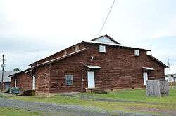
| 5 |
Damascus Gymnasium |
|
000000001992-09-04-0000September 4, 1992
(#92001122) |
Highway 285
35°22′03″N 92°24′36″W / 35.3675°N 92.41°W / 35.3675; -92.41 (Damascus Gymnasium) |
Damascus |
|
| 6 |
Edgemont Shelter |
Upload image |
000000001982-05-04-0000May 4, 1982
(#82002146) |
Address Restricted
|
Shirley |
|
| 7 |
Joclin-Bradley-Bowling House |
|
000000002007-02-01-0000February 1, 2007
(#06001316) |
160 Highway 95, W.
35°35′49″N 92°27′46″W / 35.596944°N 92.462778°W / 35.596944; -92.462778 (Joclin-Bradley-Bowling House) |
Clinton |
|
| 8 |
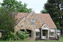
Carl and Esther Lee House |
|
000000002005-10-19-0000October 19, 2005
(#05001170) |
17493 U.S. Highway 65 South
35°22′02″N 92°24′29″W / 35.367222°N 92.408056°W / 35.367222; -92.408056 (Carl and Esther Lee House) |
Damascus |
|
| 9 |
Lynn Creek Shelter |
Upload image |
000000001978-03-21-0000March 21, 1978
(#78000634) |
Address Restricted
|
Fairfield Bay |
|
| 10 |
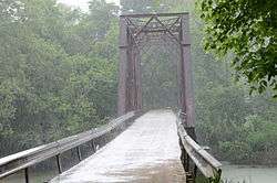
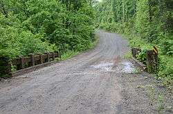
Middle Fork of the Little Red River Bridge |
|
000000002010-01-21-0000January 21, 2010
(#09001260) |
County Road 125 over the Middle Fork of the Little Red River
35°39′34″N 92°19′20″W / 35.659503°N 92.322094°W / 35.659503; -92.322094 (Middle Fork of the Little Red River Bridge) |
Shirley |
|
| 11 |
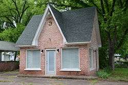
Walter Patterson Filling Station |
|
000000002001-02-09-0000February 9, 2001
(#01000074) |
U.S. Highway 65 between Griggs and Court Sts.
35°35′29″N 92°27′26″W / 35.591389°N 92.457222°W / 35.591389; -92.457222 (Walter Patterson Filling Station) |
Clinton |
|
| 12 |
Walter Patterson House |
|
000000002007-06-05-0000June 5, 2007
(#07000504) |
1800 U.S. Highway 65 North
35°36′42″N 92°27′26″W / 35.611667°N 92.457222°W / 35.611667; -92.457222 (Walter Patterson House) |
Clinton |
|
| 13 |
Art Scanlan House |
|
000000001999-11-18-0000November 18, 1999
(#99001355) |
Route 1, west of U.S. Highway 65
35°26′52″N 92°23′38″W / 35.447778°N 92.393889°W / 35.447778; -92.393889 (Art Scanlan House) |
Bee Branch |
|
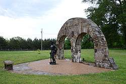
| 14 |
Titan II ICBM Launch Complex 374-7 Site |
Upload image |
000000002000-02-18-0000February 18, 2000
(#98001434) |
West of U.S. Highway 65, 1.7 miles north of its junction with Highway 124
35°24′51″N 92°23′47″W / 35.414167°N 92.396389°W / 35.414167; -92.396389 (Titan II ICBM Launch Complex 374-7 Site) |
Southside |
|
| 15 |
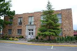
Van Buren County Courthouse |
|
000000001991-05-13-0000May 13, 1991
(#91000584) |
Junction of Griggs and Main Sts.
35°35′33″N 92°27′28″W / 35.5925°N 92.457778°W / 35.5925; -92.457778 (Van Buren County Courthouse) |
Clinton |
|
| 16 |
Van Buren County Road 2E Bridge |
|
000000001995-05-05-0000May 5, 1995
(#95000570) |
County Road 2E over a tributary of Driver's Creek
35°30′41″N 92°41′53″W / 35.511389°N 92.698056°W / 35.511389; -92.698056 (Van Buren County Road 2E Bridge) |
Scotland |
|
| [3] |
Name on the Register |
Image |
Date listed | Date removed |
Location |
City or town |
Summary |
|---|
| 1 |
Stobaugh House |
Upload image |
000000001976-07-06-0000July 6, 1976
(#76000471) | 000000002000-03-31-0000March 31, 2000 |
AR 9, 0.5 mi. SW of Choctaw
|
Choctaw vicinity |
|
See also
References
- ↑ The latitude and longitude information provided in this table was derived originally from the National Register Information System, which has been found to be fairly accurate for about 99% of listings. For about 1% of NRIS original coordinates, experience has shown that one or both coordinates are typos or otherwise extremely far off; some corrections may have been made. A more subtle problem causes many locations to be off by up to 150 yards, depending on location in the country: most NRIS coordinates were derived from tracing out latitude and longitudes off of USGS topographical quadrant maps created under the North American Datum of 1927, which differs from the current, highly accurate WGS84 GPS system used by most on-line maps. Chicago is about right, but NRIS longitudes in Washington are higher by about 4.5 seconds, and are lower by about 2.0 seconds in Maine. Latitudes differ by about 1.0 second in Florida. Some locations in this table may have been corrected to current GPS standards.
- ↑ "National Register of Historic Places: Weekly List Actions". National Park Service, United States Department of the Interior. Retrieved on July 14, 2017.
- 1 2 Numbers represent an ordering by significant words. Various colorings, defined here, differentiate National Historic Landmarks and historic districts from other NRHP buildings, structures, sites or objects.
- ↑ National Park Service (2009-03-13). "National Register Information System". National Register of Historic Places. National Park Service.
- ↑ The eight-digit number below each date is the number assigned to each location in the National Register Information System database, which can be viewed by clicking the number.
|
|---|
| Topics | |
|---|
| Lists by states | |
|---|
| Lists by insular areas | |
|---|
| Lists by associated states | |
|---|
| Other areas | |
|---|
-
 Portal Portal
|
|
|---|
|
| Cities | | |
|---|
| Towns | |
|---|
| CDP | |
|---|
| Townships |
- Archey Valley
- Barnett
- Bradley
- Cadron
- Cargile
- Choctaw
- Craig
- Culpepper
- Davis
- East Griggs
- Formosa
- Holly Mountain
- Indian Rock
- Liberty
- Linn Creek
- Mountain
- Red River
- Union
- Washington
- West Griggs
- Wheeler
|
|---|
Unincorporated
communities | |
|---|
| Ghost town | |
|---|
| Footnotes | ‡This populated place also has portions in an adjacent county or counties |
|---|