National Register of Historic Places listings in Otter Tail County, Minnesota

Location of Otter Tail County in Minnesota
This is a list of the National Register of Historic Places listings in Otter Tail County, Minnesota. It is intended to be a complete list of the properties and districts on the National Register of Historic Places in Otter Tail County, Minnesota, United States. The locations of National Register properties and districts for which the latitude and longitude coordinates are included below, may be seen in an online map.[1]
There are 24 properties and districts listed on the National Register in the county. A supplementary list includes two additional sites that were formerly on the National Register.
- This National Park Service list is complete through NPS recent listings posted July 14, 2017.[2]
Current listings
| [3] | Name on the Register | Image | Date listed[4] | Location | City or town | Description |
|---|---|---|---|---|---|---|
| 1 | Barnard Mortuary | 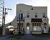 |
August 13, 1986 (#86001538) |
119 N. Union Ave. 46°17′03″N 96°04′41″W / 46.284126°N 96.078154°W |
Fergus Falls | 1930 Mission Revival funeral home.[5] |
| 2 | O.A.E. Blyberg House |  |
February 16, 1984 (#84001631) |
22 5th Ave., SW 46°33′51″N 96°05′05″W / 46.564268°N 96.084698°W |
Pelican Rapids | 1884 brick Italianate house.[5] |
| 3 | C.C. Clement House |  |
August 13, 1986 (#86001485) |
608 N. Burlington Ave. 46°17′20″N 96°03′48″W / 46.288856°N 96.063198°W |
Fergus Falls | 1882 frame Stick-Eastlake house designed by Charles N. Daniels.[5] |
| 4 | Craigie Flour Mill Historical Marker | 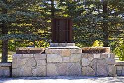 |
January 16, 2003 (#02001704) |
Minnesota Highway 78 at Balmoral Creek 46°22′26″N 95°39′05″W / 46.373883°N 95.651345°W |
Otter Tail Township | 1940 Rustic Style wayside built by the National Youth Administration, commemorating the site of an 1870 gristmill.[6] |
| 5 | District No. 182 School | 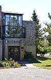 |
August 9, 1991 (#91000978) |
Off County Highway 35 46°22′07″N 95°51′47″W / 46.368675°N 95.863078°W |
Underwood vicinity | 1940 split-stone Moderne school built by the Works Progress Administration.[5] |
| 6 | Elizabeth Village Hall and Jail | 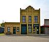 |
February 16, 1984 (#84001634) |
Broadway Ave. 46°22′47″N 96°07′52″W / 46.379645°N 96.131208°W |
Elizabeth | 1898 brick municipal building.[5] |
| 7 | Fergus Falls City Hall | 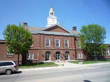 |
May 10, 1984 (#84001635) |
112 W. Washington Ave. 46°16′54″N 96°04′30″W / 46.281686°N 96.075085°W |
Fergus Falls | 1928 Georgian Revival municipal building patterned after Independence Hall.[5] |
| 8 | Fergus Falls State Hospital Complex | .jpg) |
June 26, 1986 (#86001386) |
Minnesota Highway 297; also 1400 Union Ave., N. and bounded by Fir Ave. and Park St. 46°17′58″N 96°04′54″W / 46.299575°N 96.081587°W |
Fergus Falls | 1888–1907 hospital complex, the only remaining state institution built on the Kirkbride Plan.[7] Second set of addresses represents a boundary increase, approved November 3, 2016. |
| 9 | Fort Juelson |  |
October 16, 2013 (#13000836) |
Address Restricted 46°16′21″N 95°49′50″W / 46.272436°N 95.830446°W |
Tordenskjold vicinity | Hilltop site of a Woodland period burial mound group and an 1876 sod fort built by white settlers during widespread fear of attack after the Sioux victory at the Battle of the Little Bighorn.[8] Now a county park.[9] |
| 10 | Hotel Kaddatz |  |
February 24, 1983 (#83000924) |
111-113 W. Lincoln Ave. 46°17′00″N 96°04′30″W / 46.283325°N 96.074882°W |
Fergus Falls | 1915 Renaissance Revival hotel designed by George Hancock.[5] |
| 11 | Maplewood Site |  |
December 18, 1978 (#78001555) |
Address Restricted |
Pelican Rapids vicinity | Habitation site occupied 650–900 and 1450–1650.[5] |
| 12 | John W. Mason House |  |
August 13, 1986 (#86001533) |
205 W. Vernon Ave. 46°16′41″N 96°04′35″W / 46.278016°N 96.076282°W |
Fergus Falls | c. 1881 frame Italianate house of Fergus Falls' first mayor.[5] |
| 13 | Morrison Mounds | |
June 4, 1973 (#73000991) |
Address Restricted |
Battle Lake vicinity | c. 500–200 BCE mound group.[5] |
| 14 | Orwell Site | |
December 4, 1974 (#74001032) |
Address Restricted |
Fergus Falls vicinity | 12 Middle or Late Woodland period mounds, four enclosed by an earthwork.[10] |
| 15 | Otter Tail County Courthouse |  |
May 10, 1984 (#84001637) |
121 W. Junius Ave. 46°16′48″N 96°04′30″W / 46.279921°N 96.07501°W |
Fergus Falls | 1922 Beaux-Arts courthouse of brick and limestone, designed by Buechner & Orth.[5] |
| 16 | Park Region Luther College |  |
November 8, 1984 (#84000241) |
715 W. Vernon Ave. 46°16′41″N 96°05′09″W / 46.277945°N 96.08597°W |
Fergus Falls | 1901 Romanesque campus building of brick and sandstone, designed by Omeyer & Thori.[5] Now houses Hillcrest Lutheran Academy. |
| 17 | People's Union Church | 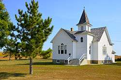 |
August 11, 2004 (#04000836) |
48566 205th Ave. 46°40′00″N 96°04′03″W / 46.666804°N 96.067398°W |
Scambler Township | 1915 non-denominational church established and run by women.[5] |
| 18 | Perham Village Hall and Fire Station | 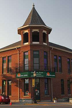 |
July 31, 1986 (#86002122) |
153 E. Main 46°35′38″N 95°34′18″W / 46.593841°N 95.571705°W |
Perham | 1906 brick municipal building designed by Fremont D. Orff.[5] |
| 19 | Phelps Mill | 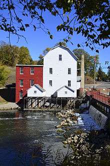 |
February 24, 1975 (#75002145) |
County Highway 45 46°22′49″N 95°49′16″W / 46.380411°N 95.821102°W |
Underwood vicinity | 1889 water-powered gristmill, expanded to process additional grains.[11] Also a contributing property to the Phelps Mill Historic District.[12] |
| 20 | Phelps Mill Historic District |  |
May 10, 1984 (#84001640) |
County Highway 45 46°22′49″N 95°49′15″W / 46.380196°N 95.820715°W |
Underwood vicinity | Agricultural center comprising the 1889 Phelps Mill, an 1891 general store, and a 1902 frame Italianate miller's house.[5] Now a county park.[13] |
| 21 | Prospect House | 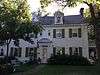 |
May 28, 2013 (#13000326) |
403 Lake Avenue N. 46°17′08″N 95°42′53″W / 46.285676°N 95.714713°W |
Battle Lake | Exemplary Georgian Revival house stemming from a 1929 conversion of an 1887 inn, reflecting the era's interest in authentic early American architecture.[14] Now a museum.[15] |
| 22 | River Inn |  |
December 20, 1988 (#88002831) |
133 Mill St., S. 46°16′57″N 96°04′26″W / 46.282491°N 96.07375°W |
Fergus Falls | 1929 Georgian/Gothic hotel built to serve the federal courthouse opposite.[5] |
| 23 | United States Post Office and Courthouse |  |
October 24, 2012 (#12000879) |
118 S. Mill St. 46°16′58″N 96°04′28″W / 46.28268°N 96.074404°W |
Fergus Falls | |
| 24 | C.J. Wright House | 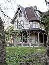 |
November 30, 1978 (#78001554) |
831 Mount Faith Ave., E. 46°17′17″N 96°03′42″W / 46.288103°N 96.061782°W |
Fergus Falls | 1882 frame Stick style house.[5] |
Former listings
| [3] | Name on the Register | Image | Date listed | Date removed | Location | City or town | Summary |
|---|---|---|---|---|---|---|---|
| 1 | Henry G. Page House | Upload image | March 3, 1975 (#75001004) | November 13, 1987 | 219 N. Whitford St. |
Fergus Falls | 1870 Italianate house.[16] Moved in 1977.[5] |
| 2 | E. J. Webber House | Upload image | August 13, 1986 (#86001497) | May 22, 1992 | 506 W. Lincoln Ave. |
Fergus Falls | 1896 Queen Anne house designed by Omeyer & Thori.[17] Moved in 1991.[5] |
See also
- List of National Historic Landmarks in Minnesota
- National Register of Historic Places listings in Minnesota
References
- ↑ The latitude and longitude information provided in this table was derived originally from the National Register Information System, which has been found to be fairly accurate for about 99% of listings. For about 1% of NRIS original coordinates, experience has shown that one or both coordinates are typos or otherwise extremely far off; some corrections may have been made. A more subtle problem causes many locations to be off by up to 150 yards, depending on location in the country: most NRIS coordinates were derived from tracing out latitude and longitudes off of USGS topographical quadrant maps created under the North American Datum of 1927, which differs from the current, highly accurate WGS84 GPS system used by most on-line maps. Chicago is about right, but NRIS longitudes in Washington are higher by about 4.5 seconds, and are lower by about 2.0 seconds in Maine. Latitudes differ by about 1.0 second in Florida. Some locations in this table may have been corrected to current GPS standards.
- ↑ "National Register of Historic Places: Weekly List Actions". National Park Service, United States Department of the Interior. Retrieved on July 14, 2017.
- 1 2 Numbers represent an ordering by significant words. Various colorings, defined here, differentiate National Historic Landmarks and historic districts from other NRHP buildings, structures, sites or objects.
- ↑ The eight-digit number below each date is the number assigned to each location in the National Register Information System database, which can be viewed by clicking the number.
- 1 2 3 4 5 6 7 8 9 10 11 12 13 14 15 16 17 18 19 Nord, Mary Ann (2003). The National Register of Historic Places in Minnesota. Minnesota Historical Society. ISBN 0-87351-448-3.
- ↑ "Craigie Flour Mill Historical Marker". Minnesota National Register Properties Database. Minnesota Historical Society. Retrieved 2012-09-24.
- ↑ "Fergus Falls State Hospital Complex". A Minnesota Sampler. Minnesota Historical Society. Retrieved 2012-09-24.
- ↑ Arnott, Sigrid; Scott Brosowske; David Maki (2013-03-17). "National Register of Historic Places Registration Form: Fort Juelson" (PDF). National Park Service. Retrieved 2014-01-13.
- ↑ Hintgen, Tom (2011-06-09). "Ft. Juelson dedication on Sat.". Fergus Falls Journal. Fergus Falls, Minn. Retrieved 2014-01-15.
- ↑ Anfinson, Scott (2009). "Finding Minnesota: A Geographic Guide to Minnesota Archaeology" (PDF). Minnesota Office of the State Archaeologist. Retrieved 2012-12-18.
- ↑ "Phelps Mill". A Minnesota Sampler. Minnesota Historical Society. Retrieved 2012-09-24.
- ↑ "Phelps Mill Historic District". Minnesota Historical Society. 2009. Retrieved 2013-03-07.
- ↑ "Phelps Mill County Park". County of Otter Tail, Minnesota. Archived from the original on 2013-05-06. Retrieved 2013-03-07.
- ↑ Stark, William E. (November 2012). "National Register of Historic Places Registration Form: Prospect House" (PDF). National Park Service. Retrieved 2014-01-15.
- ↑ "Prospect House & Civil War Museum". 2014. Retrieved 2014-01-15.
- ↑ "Page, Henry G., House (removed)". Minnesota National Register Properties Database. Minnesota Historical Society. 2009. Retrieved 2013-03-05.
- ↑ "Webber, Edward J., House (removed)". Minnesota National Register Properties Database. Minnesota Historical Society. 2009. Retrieved 2013-03-05.
External links
| Wikimedia Commons has media related to National Register of Historic Places in Otter Tail County, Minnesota. |
- Minnesota National Register Properties Database—Minnesota Historical Society
| Topics | |
|---|---|
| Lists by states |
|
| Lists by insular areas | |
| Lists by associated states | |
| Other areas | |
| |
Municipalities and communities of Otter Tail County, Minnesota, United States | ||
|---|---|---|
| Cities | | |
| Townships |
| |
| Unincorporated communities | ||
| Indian reservation | ||
| Ghost towns | ||
| Footnotes | ‡This populated place also has portions in an adjacent county or counties | |
This article is issued from
Wikipedia.
The text is licensed under Creative Commons - Attribution - Sharealike.
Additional terms may apply for the media files.