| [3] |
Name on the Register |
Image |
Date listed[4] |
Location |
City or town |
Description |
|---|
| 1 |
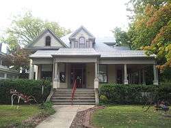
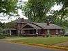
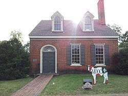
Peter F. Armistead, Sr., House |
Upload image |
000000001986-07-09-0000July 9, 1986
(#86001540) |
Waterloo Rd.
34°50′28″N 87°44′24″W / 34.841111°N 87.74°W / 34.841111; -87.74 (Peter F. Armistead, Sr., House) |
Florence |
|
| 2 |
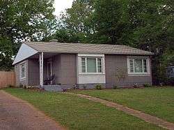
William Bowen Lustron House |
|
000000002000-02-24-0000February 24, 2000
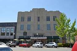
(#00000135) |
1145 Wildwood Park Rd.
34°49′00″N 87°41′18″W / 34.816728°N 87.688226°W / 34.816728; -87.688226 (William Bowen Lustron House) |
Florence |
|
| 3 |
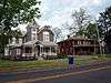
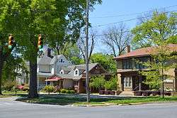
Cherry Street Historic District |
|
000000001997-07-03-0000July 3, 1997
(#97000648) |
Cherry St. between Hermitage Dr. and E. Tombigbee St.
34°48′29″N 87°40′21″W / 34.808056°N 87.672500°W / 34.808056; -87.672500 (Cherry Street Historic District) |
Florence |
|
| 4 |
Coffee High School |
Upload image |
000000001982-02-04-0000February 4, 1982
(#82002045) |
319 Hermitage Dr.
34°48′29″N 87°40′34″W / 34.80803°N 87.67604°W / 34.80803; -87.67604 (Coffee High School) |
Florence |
|
| 5 |
College Place Historic District |
|
000000001995-01-12-0000January 12, 1995
(#94001547) |
Along Sherrod Ave. between W. Lelia St. and Circular Rd.; also roughly along W. Lelia and W. Mattie Lou Sts.
34°48′46″N 87°40′51″W / 34.812778°N 87.680833°W / 34.812778; -87.680833 (College Place Historic District) |
Florence |
Second set of boundaries represents a boundary increase of 000000001998-09-14-0000September 14, 1998
|
| 6 |
George Coulter House |
|
000000001982-01-21-0000January 21, 1982
(#82002046) |
420 S. Pine St.
34°47′46″N 87°40′32″W / 34.79604°N 87.67549°W / 34.79604; -87.67549 (George Coulter House) |
Florence |
|
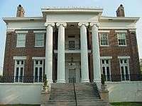
| 7 |
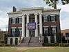
Courtview |
|
000000001974-06-13-0000June 13, 1974
(#74000415) |
Court St.
34°48′21″N 87°40′46″W / 34.805833°N 87.679444°W / 34.805833; -87.679444 (Courtview) |
Florence |
|
| 8 |
E.H. Darby Lustron House |
|
000000002000-02-24-0000February 24, 2000
(#00000127) |
321 Beverly
34°47′30″N 87°41′19″W / 34.791750°N 87.688611°W / 34.791750; -87.688611 (E.H. Darby Lustron House) |
Florence |
|
| 9 |
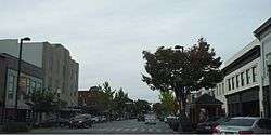
Downtown Florence Historic District |
|
000000001995-08-22-0000August 22, 1995
(#95001021) |
Roughly the eastern side of Court St. from 104 N. Court to 119 S. Court, 100-128 E. Tennessee St., and 106, 108, and 110 S. Seminary St.; also roughly bounded by Pine St., Alabama St., Wood Ave., and Tuscaloosa St.
34°48′00″N 87°40′31″W / 34.8°N 87.675278°W / 34.8; -87.675278 (Downtown Florence Historic District) |
Florence |
Second set of boundaries represents a boundary increase of 000000002001-12-18-0000December 18, 2001
|
| 10 |
Florence Wagon Works Site |
Upload image |
000000001996-06-13-0000June 13, 1996
(#96000596) |
South of Dekalb Ave. between Main and Spurr Sts.
34°48′09″N 87°38′35″W / 34.802500°N 87.643056°W / 34.802500; -87.643056 (Florence Wagon Works Site) |
Florence |
|
| 11 |
Forks of Cypress |
|
000000001997-10-10-0000October 10, 1997
(#97001166) |
Jackson Rd., roughly 1.5 miles northwest of the junction of Cox Creek Parkway and Jackson Rd.
34°50′42″N 87°43′32″W / 34.845°N 87.725556°W / 34.845; -87.725556 (Forks of Cypress) |
Florence |
|
| 12 |
Forks of Cypress Cemetery |
|
000000002000-02-24-0000February 24, 2000
(#00000140) |
0.25 miles north of Jackson Rd. on the eastern side of Dowdy Rd., north of Little Cypress Creek
34°50′53″N 87°43′19″W / 34.848056°N 87.721944°W / 34.848056; -87.721944 (Forks of Cypress Cemetery) |
Florence |
|
| 13 |
Karsner-Carroll House |
|
000000001970-03-31-0000March 31, 1970
(#70000104) |
303 N. Pine St.
34°48′05″N 87°40′43″W / 34.801500°N 87.678611°W / 34.801500; -87.678611 (Karsner-Carroll House) |
Florence |
|
| 14 |
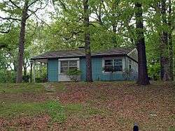
William Koger House |
Upload image |
000000001986-07-09-0000July 9, 1986
(#86001542) |
Smithsonia-Rhodesville Rd.
34°49′19″N 87°52′25″W / 34.82185°N 87.87364°W / 34.82185; -87.87364 (William Koger House) |
Smithsonia |
|
| 15 |
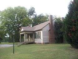
Larimore House |
Upload image |
000000001974-11-21-0000November 21, 1974
(#74000416) |
Mars Hill Rd./U.S. Route 8, Box 344
34°50′49″N 87°39′36″W / 34.84697°N 87.65995°W / 34.84697; -87.65995 (Larimore House) |
Florence |
|
| 16 |
Locust Street Historic District |
|
000000002002-10-03-0000October 3, 2002
(#02001065) |
Roughly bounded by Pine St., College St., Locust St., and Irvine Ave.
34°48′08″N 87°40′47″W / 34.802222°N 87.679722°W / 34.802222; -87.679722 (Locust Street Historic District) |
Florence |
|
| 17 |
James Martin House |
|
000000001981-12-09-0000December 9, 1981
(#81000128) |
1400 Cypress Mill Rd.
34°48′56″N 87°42′12″W / 34.81563°N 87.70334°W / 34.81563; -87.70334 (James Martin House) |
Florence |
|
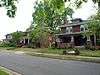
| 18 |
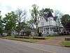
McFarland Heights |
Upload image |
000000002017-07-10-0000July 10, 2017
(#100001280) |
501-920 Riverview Dr., 701-735 Pleasant Cir., 410-456 Riverview Cir.
34°47′32″N 87°40′57″W / 34.792191°N 87.682409°W / 34.792191; -87.682409 (McFarland Heights) |
Florence |
|
| 19 |
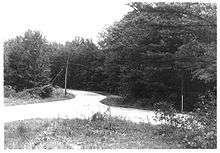
Old Natchez Trace (310-2A) |
|
000000001976-11-07-0000November 7, 1976
(#76000156) |
15 miles northwest of Florence on State Route 20
34°55′31″N 87°50′38″W / 34.925278°N 87.843889°W / 34.925278; -87.843889 (Old Natchez Trace (310-2A)) |
Florence |
1,250-foot segment of the Natchez Trace, both paved and unpaved.[5]
|
| 20 |
Governor Robert Patton House |
|
000000001976-06-17-0000June 17, 1976
(#76000335) |
Sweetwater and Florence Boulevard
34°49′28″N 87°38′34″W / 34.82446°N 87.64269°W / 34.82446; -87.64269 (Governor Robert Patton House) |
Florence |
|
| 21 |
Rogers Department Store |
|
000000001998-08-14-0000August 14, 1998
(#98001025) |
117 N. Court St.
34°48′03″N 87°40′36″W / 34.800833°N 87.676667°W / 34.800833; -87.676667 (Rogers Department Store) |
Florence |
|
| 22 |
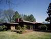
Rosenbaum House |
|
000000001978-12-19-0000December 19, 1978
(#78000492) |
601 Riverview Dr.
34°47′35″N 87°40′50″W / 34.79304°N 87.68057°W / 34.79304; -87.68057 (Rosenbaum House) |
Florence |
|
| 23 |
Sannoner Historic District |
|
000000001976-01-01-0000January 1, 1976
(#76000336) |
Includes both sides of N. Pine and N. Court from Tuscaloosa Ave. to the University of North Alabama campus
34°48′14″N 87°40′45″W / 34.803849°N 87.679095°W / 34.803849; -87.679095 (Sannoner Historic District) |
Florence |
|
| 24 |
Seminary-O'Neal Historic District |
|
000000001995-02-17-0000February 17, 1995
(#95000092) |
Roughly Seminary St. between Hermitage Dr. and Irvine Ave. and Irvine between Seminary and Wood Ave.
34°48′20″N 87°40′39″W / 34.805556°N 87.677500°W / 34.805556; -87.677500 (Seminary-O'Neal Historic District) |
Florence |
|
| 25 |
Seven Mile Island Archeological District |
Upload image |
000000001979-04-16-0000April 16, 1979
(#79003352) |
Address Restricted[6]
34°45′02″N 87°44′12″W / 34.7506°N 87.7367°W / 34.7506; -87.7367 (Seven Mile Island Archeological District) |
Florence |
|
| 26 |
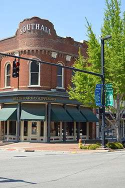
Southall Drugs |
|
000000001980-08-21-0000August 21, 1980
(#80000699) |
201 N. Court St.
34°48′04″N 87°40′37″W / 34.801111°N 87.676806°W / 34.801111; -87.676806 (Southall Drugs) |
Florence |
|
| 27 |
Walnut Street Historic District |
|
000000001976-12-12-0000December 12, 1976
(#76000337) |
N. Walnut between Hermitage and Tuscaloosa; also 415-609 N. Poplar St. (odd numbers only); also the junction of Poplar and Tuscaloosa Sts.
34°48′20″N 87°40′28″W / 34.805556°N 87.674444°W / 34.805556; -87.674444 (Walnut Street Historic District) |
Florence |
Second and third sets of boundaries represent boundary increases of 000000001993-04-04-0000April 4, 1993 and 000000001996-03-16-0000March 16, 1996 respectively
|
| 28 |
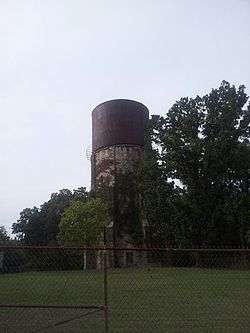
Water Tower |
|
000000001980-04-28-0000April 28, 1980
(#80000700) |
Seymore St.
34°49′29″N 87°41′27″W / 34.824722°N 87.690833°W / 34.824722; -87.690833 (Water Tower) |
Florence |
|
| 29 |
Wesleyan Hall |
|
000000001974-06-20-0000June 20, 1974
(#74000417) |
Morrison Ave.
34°48′32″N 87°40′45″W / 34.80897°N 87.67916°W / 34.80897; -87.67916 (Wesleyan Hall) |
Florence |
|
| 30 |
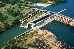
Wilson Dam |
|
000000001966-11-13-0000November 13, 1966
(#66000147) |
On the Tennessee River along State Route 133
34°48′03″N 87°37′33″W / 34.800917°N 87.625817°W / 34.800917; -87.625817 (Wilson Dam) |
Florence |
Extends into Colbert County
|
| 31 |
Wilson Park Houses |
|
000000001979-01-25-0000January 25, 1979
(#79000390) |
209, 217, and 223 E. Tuscaloosa St.
34°48′14″N 87°40′31″W / 34.803889°N 87.675278°W / 34.803889; -87.675278 (Wilson Park Houses) |
Florence |
|
| 32 |
Wood Avenue Historic District |
|
000000001978-10-10-0000October 10, 1978
(#78000493) |
N. Wood Ave. roughly bounded by Tuscaloosa and Hawthorne Sts.; also roughly along E. Hawthorne, Meridian and Kendrick Sts.; also roughly along Kendrick Ave. and 633 Hermitage Dr.
34°48′26″N 87°40′37″W / 34.807222°N 87.676944°W / 34.807222; -87.676944 (Wood Avenue Historic District) |
Florence |
Second and third sets of boundaries represent boundary increases of 000000001996-03-16-0000March 16, 1996 and 000000001997-08-03-0000August 3, 1997 respectively |

.jpg)

.jpg)
.jpg)