| [3] |
Name on the Register[4] |
Image |
Date listed[5] |
Location |
City or town |
Description |
|---|
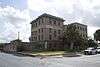
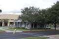
| 1 |
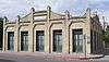
Brazos Santiago Depot |
Upload image |
000000001971-07-14-0000July 14, 1971
(#71000923) |
Restricted
|
Port Isabel |
|
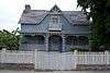
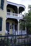
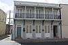
| 2 |
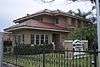
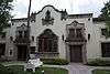
Samuel Wallace Brooks House |
|
000000001988-11-22-0000November 22, 1988
(#88002530) |
623 E St. Charles St.
25°54′14″N 97°30′12″W / 25.90375°N 97.503472°W / 25.90375; -97.503472 (Samuel Wallace Brooks House) |
Brownsville |
|
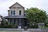
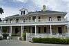
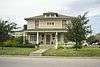
| 3 |
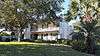
Brown-Wagner House |
|
000000001977-08-29-0000August 29, 1977
(#77001430) |
245 E St. Charles St.
25°54′23″N 97°30′22″W / 25.90625°N 97.506042°W / 25.90625; -97.506042 (Brown-Wagner House) |
Brownsville |
|
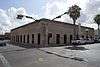
| 4 |
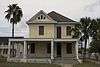
Brownsville City Cemetery and Hebrew Cemetery |
|
000000002010-03-31-0000March 31, 2010
(#10000143) |
Bound by E. 5th St., Madison St., E 2nd St., and Town Resaca
25°54′34″N 97°30′00″W / 25.909514°N 97.5°W / 25.909514; -97.5 (Brownsville City Cemetery and Hebrew Cemetery) |
Brownsville |
|
| 5 |
Old Brulay Plantation |
Upload image |
000000001975-10-10-0000October 10, 1975
(#75001961) |
East of Brownsville off of TX 4
25°51′16″N 97°24′01″W / 25.854531°N 97.400289°W / 25.854531; -97.400289 (Old Brulay Plantation) |
Brownsville |
Also known as the Nye Plantation[6]
|
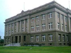
| 6 |
Cameron County Courthouse |
|
000000001980-09-27-0000September 27, 1980
(#80004084) |
1150 E Madison St.
25°54′15″N 97°29′43″W / 25.904167°N 97.495347°W / 25.904167; -97.495347 (Cameron County Courthouse) |
Brownsville |
|
| 7 |
Old Cameron County Jail |
|
000000001995-01-24-0000January 24, 1995
(#94001594) |
1201 E Van Buren
25°54′19″N 97°29′34″W / 25.905278°N 97.492847°W / 25.905278; -97.492847 (Old Cameron County Jail) |
Brownsville |
|
| 8 |
Augustine Celaya House |
|
000000001986-04-11-0000April 11, 1986
(#86000726) |
504 E St. Francis St.
25°54′13″N 97°30′19″W / 25.903681°N 97.505347°W / 25.903681; -97.505347 (Augustine Celaya House) |
Brownsville |
|
| 9 |
Celaya-Creager House |
|
000000001988-05-05-0000May 5, 1988
(#88000523) |
441 E Washington St.
25°54′25″N 97°30′09″W / 25.906806°N 97.5025°W / 25.906806; -97.5025 (Celaya-Creager House) |
Brownsville |
|
| 10 |
Miguel Fernandez Hide Yard |
|
000000001990-10-01-0000October 1, 1990
(#90001485) |
1101-1121 E Adams St.
25°54′11″N 97°29′51″W / 25.902947°N 97.497414°W / 25.902947; -97.497414 (Miguel Fernandez Hide Yard) |
Brownsville |
also known as El Aleman
|
| 11 |
Fort Brown |
|
000000001966-10-15-0000October 15, 1966
(#66000811) |
S edge of Brownsville off of International Blvd.
25°53′50″N 97°29′26″W / 25.897222°N 97.490556°W / 25.897222; -97.490556 (Fort Brown) |
Brownsville |
|
| 12 |
M.E. Garcia and Estela Cueto House |
Upload image |
000000002017-06-05-0000June 5, 2017
(#100001038) |
155 Calle Anacua
25°55′01″N 97°30′11″W / 25.916861°N 97.503116°W / 25.916861; -97.503116 (M.E. Garcia and Estela Cueto House) |
Brownsville |
|
| 13 |
Garcia Pasture Site |
Upload image |
000000001972-02-23-0000February 23, 1972
(#72001355) |
Restricted
|
Port Isabel |
|
| 14 |
The Gem |
|
000000001991-06-28-0000June 28, 1991
(#91000852) |
400 E 13th St.
25°54′00″N 97°29′52″W / 25.89989°N 97.49768°W / 25.89989; -97.49768 (The Gem) |
Brownsville |
|
| 15 |
Hicks-Gregg House |
|
000000002009-07-01-0000July 1, 2009
(#09000486) |
1249 W. Washington
25°55′06″N 97°30′56″W / 25.918375°N 97.515536°W / 25.918375; -97.515536 (Hicks-Gregg House) |
Brownsville |
|
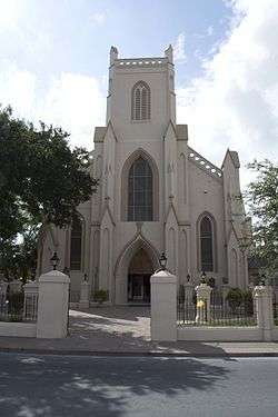
| 16 |
Immaculate Conception Church |
|
000000001980-03-26-0000March 26, 1980
(#80004085) |
1218 E Jefferson St.
25°54′09″N 97°29′45″W / 25.9025°N 97.495972°W / 25.9025; -97.495972 (Immaculate Conception Church) |
Brownsville |
|
| 17 |
La Madrilena |
|
000000001988-11-17-0000November 17, 1988
(#88002384) |
1002 E Madison
25°54′17″N 97°29′49″W / 25.904722°N 97.496806°W / 25.904722; -97.496806 (La Madrilena) |
Brownsville |
|
| 18 |
Manautou House |
|
000000001983-07-14-0000July 14, 1983
(#83003130) |
5 E Elizabeth St.
25°54′33″N 97°30′23″W / 25.909236°N 97.506458°W / 25.909236; -97.506458 (Manautou House) |
Brownsville |
|
| 19 |
McNair House |
|
000000002015-11-24-0000November 24, 2015
(#15000836) |
39 Sunset Drive
25°55′08″N 97°29′52″W / 25.918960°N 97.497848°W / 25.918960; -97.497848 (McNair House) |
Brownsville |
|
| 20 |
Morris-Browne House |
|
000000002006-10-25-0000October 25, 2006
(#06000955) |
204 E Levee St.
25°54′25″N 97°30′22″W / 25.90695°N 97.506111°W / 25.90695; -97.506111 (Morris-Browne House) |
Brownsville |
|
| 21 |
La Nueva Libertad |
|
000000001986-04-11-0000April 11, 1986
(#84001628) |
1301 E Madison
25°54′10″N 97°29′40″W / 25.902778°N 97.494375°W / 25.902778; -97.494375 (La Nueva Libertad) |
Brownsville |
also known as the Cueto Building
|
| 22 |
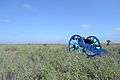
Palmito Ranch Battlefield |
|
000000001996-10-15-0000October 15, 1996
(#93000266) |
Between TX 4 and the Rio Grande, 12 mi. E of Brownsville
25°56′48″N 97°17′07″W / 25.946667°N 97.285278°W / 25.946667; -97.285278 (Palmito Ranch Battlefield) |
Brownsville |
|
| 23 |
Palo Alto Battlefield National Historical Park |
|
000000001966-10-15-0000October 15, 1966
(#66000812) |
6.3 miles N of Brownsville at intersection of FM 1847 and FM 511
26°01′04″N 97°28′50″W / 26.017886°N 97.480617°W / 26.017886; -97.480617 (Palo Alto Battlefield National Historical Park) |
Brownsville |
Ref #66000812
|
| 24 |
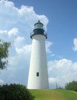
Point Isabel Lighthouse |
|
000000001976-04-30-0000April 30, 1976
(#76002014) |
Corner of TX 100 and Garcia St.
26°04′39″N 97°12′27″W / 26.077633°N 97.207583°W / 26.077633; -97.207583 (Point Isabel Lighthouse) |
Port Isabel |
|
| 25 |
Resaca De La Palma Battlefield |
|
000000001986-04-11-0000April 11, 1986
(#66000813) |
North of intersection of Paredes Line Rd and Price Rd.
25°56′15″N 97°29′10″W / 25.9375°N 97.486111°W / 25.9375; -97.486111 (Resaca De La Palma Battlefield) |
Brownsville |
Now a portion of the Palo Alto Battlefield National Historical Park
|
| 26 |
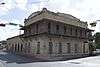
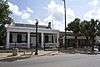
Southern Pacific Railroad Passenger Depot |
|
000000001978-11-17-0000November 17, 1978
(#78002903) |
601 E Madison St.
25°54′27″N 97°29′57″W / 25.9075°N 97.499236°W / 25.9075; -97.499236 (Southern Pacific Railroad Passenger Depot) |
Brownsville |
|
| 27 |
Charles Stillman House |
|
000000001979-11-19-0000November 19, 1979
(#79003448) |
1305 E Washington St.
25°54′03″N 97°29′47″W / 25.900833°N 97.496319°W / 25.900833; -97.496319 (Charles Stillman House) |
Brownsville |
|