Nasarawa State
| Nasarawa | ||
|---|---|---|
| State | ||
| ||
| Nickname(s): Home of Solid Minerals | ||
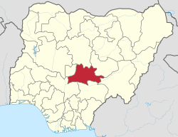
 Location of Nasarawa State in Nigeria | ||
| Coordinates: 8°32′N 8°18′E / 8.533°N 8.300°ECoordinates: 8°32′N 8°18′E / 8.533°N 8.300°E | ||
| Country |
| |
| Date created | 1 October 1996 | |
| Capital | Lafia | |
| Government | ||
| • Governor[1] | Umaru Tanko Al-Makura | |
| • Deputy Governor | Silas Ali Agara | |
| • Representatives | List | |
| Area | ||
| • Total | 27,117 km2 (10,470 sq mi) | |
| Population (2005) | ||
| • Total | 2,040,112 | |
| • Density | 75/km2 (190/sq mi) | |
| GDP (PPP) | ||
| • Year | 2007 | |
| • Total | $3.02 billion[2] | |
| • Per capita | $1,588[2] | |
| Time zone | WAT (UTC+01) | |
| ISO 3166 code | NG-NA | |
| Website |
www | |
Nasarawa is a state in north central Nigeria. Its capital is Lafia.
History
Nasarawa was created on 1 October 1996 by the Abacha government from the (today neighboring) Plateau State.[3]
Geography
Nasarawa State is bounded in the north by Kaduna State, in the west by the Abuja Federal Capital Territory, in the south by Kogi and Benue States and in the east by Taraba and Plateau States.
A network of roads exist within the state, linking all rural areas and major towns. The Nigerian Railway Corporation (NRC) operates train services from Kuru, Gombe and Maiduguri.
Local Government Areas
The State has three National Senatorial Districts (South, North and West).
Nasarawa State consists of thirteen (13) Local Government Areas (shown with 2006 population figures[4]):
| Nasarawa West Senatorial District | 716,802 | Nasarawa North Senatorial District | 335,453 | Nasarawa South Senatorial District | 811,020 | ||
|---|---|---|---|---|---|---|---|
| Karu | 205,477 | Akwanga | 113,430 | Awe | 112,574 | ||
| Keffi | 92,664 | Nasarawa Egon | 149,129 | Doma | 139,607 | ||
| Kokona | 109,749 | Wamba | 72,894 | Keana | 79,253 | ||
| Nasarawa | 189,835 | Lafia | 330,712 | ||||
| Toto | 119,077 | Obi | 148,874 |
List of current Local Government Area Chairmen.[5]
Economy

Nasarawa State has agriculture as the mainstay of its economy with the production of varieties of cash crops throughout the year. It also contains various minerals such as salt, baryte, and bauxite, which are mostly mined by artisanal miners.
Education
The state has a College of Education in Akwanga, College of Agriculture in Lafia, Nasarawa State Polytechnic in Lafia, Nasarawa State University in Keffi, a newly established Federal University of Lafia, and other vocational training schools.
Tourism
Nasarawa State is home to the Farin Ruwa Falls in Wamba Local Government area of the state. Farin Ruwa falls is reputed to be one of the highest falls in Africa.[6]
There is also the Salt Village in Keana Local Government Area of the State. It produces naturally iodized salt from the lake located near it.The town is also one of the cradles of Alago civilization, one of the major ethnic groups in the state.
References
- ↑ See List of Governors of Nasarawa State for a list of prior governors
- 1 2 "C-GIDD (Canback Global Income Distribution Database)". Canback Dangel. Retrieved 2008-08-20.
- ↑ Brief Data
- ↑ 2006 Population Census, Federal Republic of Nigeria, National Bureau of Statistics. Archived from the original on 2009-03-25.
- ↑ http://www.nasarawastatenigeria.com/blog/2014/03/24/list-of-newly-elected-chairmen-of-local-government-councils-in-nasarawa-state/
- ↑ Dreaming of Farin Ruwa | GlobalPost
