Narashino
| Narashino 習志野市 | |||
|---|---|---|---|
| City | |||
|
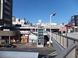
Area around JR Tsudanuma Station | |||
| |||
 Location of Narashino in Chiba Prefecture | |||
 Narashino
| |||
| Coordinates: 35°40′49.4″N 140°01′35.4″E / 35.680389°N 140.026500°ECoordinates: 35°40′49.4″N 140°01′35.4″E / 35.680389°N 140.026500°E | |||
| Country | Japan | ||
| Region | Kantō | ||
| Prefecture | Chiba Prefecture | ||
| Government | |||
| • -Mayor | Taisuke Miyamoto (since May 2011) | ||
| Area | |||
| • Total | 20.97 km2 (8.10 sq mi) | ||
| Population (December 1, 2015) | |||
| • Total | 170,331 | ||
| • Density | 8,120/km2 (21,000/sq mi) | ||
| Time zone | Japan Standard Time (UTC+9) | ||
| - Tree | Acacia | ||
| - Flower | Hydrangea | ||
| Phone number | 047-451-1151 | ||
| Address | 1-1 Saginuma, Narashino-shi, Chiba-ken 275-8601 | ||
| Website | Official website | ||

Narashino (習志野市 Narashino-shi) is a city located in northern Chiba Prefecture, Japan. [1][2] As of December 1, 2015, the city had an estimated population of 170,331 and a population density of 8,120 persons per km². The total area was 20.97 square kilometres (8.10 sq mi).
Geography
Narashino is located in far northwestern Chiba Prefecture, bordered by Tokyo Bay to the southwest.[3] The city is located on the Shimōsa Plateau and reclaimed land fill on Tokyo Bay.[2]
Surrounding municipalities
Chiba Prefecture
History
The area around Narashino has been inhabited since prehistoric times. Archaeologists have found shell middens and numerous other remains from Jomon period, as well as burial tumuli from the Kofun period. However, for most of its history, the area was a sparsely populated wetland and swamp along the northern shore of Edo Bay.
After the Meiji Restoration, Tsudanuma (津田沼村 Tsudanuma-mura) was founded within Chiba District on April 1, 1889 on the merger of five small hamlets with a total population of 4500 people. The area only began to develop with the coming of the railway, and Tsudanuma was raised to town status on March 3, 1903, with a population of 6,000.
The Narashino area of Tsudanuma was used for cavalry maneuvers by the Imperial Guard and the early Imperial Japanese Army, and was visited by the Meiji Emperor early in the Meiji period (1868 – 1912).[4][2] A prisoner of war camp was built in 1904 to house POWs from the Russo-Japanese War of 1904-1905 and World War I. The Imperial Japanese Army Narashino School was the main training school for cavalry, and later for tank warfare.[1]
On August 1, 1954, Tsudanuma merged with a portion of the neighboring city of Chiba (the former town of Makuhari) to form the new city of Narashino. [4]
Economy
Narashino is a regional commercial center and a bedroom community for nearby Chiba and Tokyo. The coastal area, mostly on reclaimed land is part of the Keiyō Industrial Zone and is home to much heavy industry, especially related to chemical processing.
Transportation
Railways
- ■ East Japan Railway Company - ■ Sōbu Main Line
- ■ Keiyō Line
- ■ Keisei Electric Railway - Main Line
- ■ Keisei Electric Railway - Chiba Line
- Keisei Tsudanuma
- ■ Shin-Keisei Electric Railway - Shin-Keisei Line
- Keisei Tsudanuma - Shin-Tsudanuma
Highways
Education
- Chiba Institute of Technology
- Narashino has 16 elementary schools, eight middle schools and four high schools
Local attractions
- Akitsu baseball stadium
- Akitsu soccer stadium
- Chiba International General Swimming Center
Notable places
- Yatsu-higata (谷津干潟), a Ramsar Site and protected wetlands for migratory birds. The spring and summer months see an increase of jellyfish and small crabs to the wetlands.[3]
- Yatsu Bara-en (谷津バラ園), a rose garden which displays over 6000 individual blossoms in May and October. The garden was founded with Yatsu Yūen (谷津遊園), an amusement park which was managed by Keisei Electric Railway and closed in 1982. When the park was closed, the city bought the garden, and has managed it since that time.
Sister city relations
Noted people from Narashino
- Daiki Arioka – Hey! Say! JUMP
- Kazuya Fukuura – professional baseball player
- Kota Hattori – professional soccer player
- Hideaki Kitajima – professional soccer player
- Makoto Sunakawa – professional soccer player
- Daichi Suzuki – swimmer, Olympic gold medalist
- Masaaki Takada – professional soccer player
References
- 1 2 "Narashino". Encyclopedia of Japan. Tokyo: Shogakukan. 2012. OCLC 56431036. Retrieved 2012-07-26.
- 1 2 3 "習志野(市)" [Narashino]. Nihon Daihyakka Zensho (Nipponika) (in Japanese). Tokyo: Shogakukan. 2012. OCLC 153301537. Retrieved 2012-07-15.
- 1 2 "習志野" [Narashino]. Dijitaru Daijisen (in Japanese). Tokyo: Shogakukan. 2012. OCLC 56431036. Retrieved 2012-07-26.
- 1 2 "習志野" [Narashino]. Nihon Kokugo Daijiten (in Japanese). Tokyo: Shogakukan. 2012. OCLC 56431036. Retrieved 2012-07-12.
- ↑ "Interactive City Directory". Sister Cities International. Retrieved 11 March 2014.
External links
| Wikimedia Commons has media related to Narashino, Chiba. |
- Official website (in Japanese)


