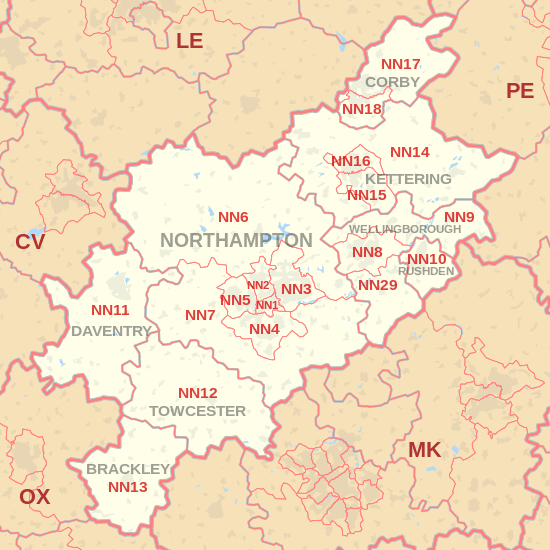
NN postcode area
Postcode district boundaries: Google
| Northampton postcode area | |
|---|---|
 NN | |
| Postcode area | NN |
| Postcode area name | Northampton |
| Post towns | 8 |
| Postcode districts | 20 |
| Postcode sectors | 101 |
| Postcodes (live) | 15,600 |
| Postcodes (total) | 23,459 |
| Statistics as at February 2012[1] | |
The NN postcode area, also known as the Northampton postcode area,[2] is a group of nineteen postcode districts in England, which are subdivisions of eight post towns. These postcode districts cover most of Northamptonshire, including Northampton, Kettering, Wellingborough, Corby, Brackley, Daventry, Rushden and Towcester, plus very small parts of Bedfordshire, Buckinghamshire, Oxfordshire and Warwickshire.
Coverage
The approximate coverage of the postcode districts:
| Postcode district | Post town | Coverage | Local authority area |
|---|---|---|---|
| NN1 | NORTHAMPTON | Northampton | Northampton |
| NN2 | NORTHAMPTON | Kingsthorpe | Northampton |
| NN3 | NORTHAMPTON | Abington (East), Bellinge, Blackthorn, Boothville, Ecton Brook, Great Billing, Headlands, Kingsley Park, Lings, Little Billing, Moulton, Moulton Park, Rectory Farm, Round Spinney, Southfields, Spinney Hill, Standens Barn, Weston Favell | Daventry, Northampton |
| NN4 | NORTHAMPTON | Brackmills, Delapré, East Hunsbury, Far Cotton, Grange Park, Great Houghton, Hardingstone, West Hunsbury, Wootton | Northampton, South Northamptonshire |
| NN5 | NORTHAMPTON | Duston, New Duston Kings Heath, St James, Dallington, Spencer, St Crispins, Upton | Northampton |
| NN6 | NORTHAMPTON | Brixworth, Cold Ashby, Earls Barton, Ecton, Guilsborough, Long Buckby Spratton, Sywell, West Haddon | Daventry, Northampton, Wellingborough |
| NN7 | NORTHAMPTON | Alderton, Blisworth, Bugbrooke, Castle Ashby, Cogenhoe, Dodford, Flore, Gayton, Grafton Regis, Hackleton, Harpole, Harlestone, Hartwell, Horton, Milton Malsor, Nether Heyford, Piddington, Preston Deanery, Quinton, Roade, Rothersthorpe, Stoke Bruerne, Weedon Bec, Yardley Gobion, Yardley Hastings | Daventry, South Northamptonshire |
| NN8 | WELLINGBOROUGH | Wellingborough, Wilby | Wellingborough |
| NN9 | WELLINGBOROUGH | Wellingborough, Chelveston, Finedon, Great Harrowden, Irthlingborough, Little Harrowden, Raunds | East Northamptonshire, Wellingborough |
| NN10 | RUSHDEN | Higham Ferrers, Rushden, Wymington | East Northamptonshire, Bedford |
| NN11 | DAVENTRY | Braunston, Daventry, Greens Norton, Hinton, Moreton Pinkney, Welton, Lower Shuckburgh | Daventry, Stratford-on-Avon |
| NN12 | TOWCESTER | Abthorpe, Caswell, Greens Norton, Silverstone, Towcester, Weston | South Northamptonshire |
| NN13 | BRACKLEY | Brackley, Croughton, Farthinghoe, Hinton-in-the-Hedges, Westbury, Turweston, Mixbury | South Northamptonshire, Aylesbury Vale, Cherwell |
| NN14 | KETTERING | Broughton, Desborough, Geddington, Isham, Pytchley, Rothwell, Thorpe Malsor, Thrapston | East Northamptonshire, Kettering |
| NN15 | KETTERING | Burton Latimer, Barton Seagrave | Kettering |
| NN16 | KETTERING | Kettering | Kettering |
| NN17 | CORBY | Bulwick, Corby | Corby, East Northamptonshire |
| NN18 | CORBY | Great Oakley, Little Oakley | Corby |
| NN29 | WELLINGBOROUGH | Bozeat, Great Doddington, Irchester, Podington, Wollaston | Bedford, Wellingborough |
| NN99 | Non-geographic |
Map
See also
References
- ↑ "ONS Postcode Directory Version Notes" (ZIP). National Statistics Postcode Products. Office for National Statistics. February 2012. Table 2. Retrieved 21 April 2012. Coordinates from mean of unit postcode points, "Code-Point Open". OS OpenData. Ordnance Survey. February 2012. Retrieved 21 April 2012.
- ↑ Royal Mail, Address Management Guide, (2004)
External links
This article is issued from
Wikipedia.
The text is licensed under Creative Commons - Attribution - Sharealike.
Additional terms may apply for the media files.
