Mu'minobod District
| Mu'minobod District Ноҳияи Мӯъминобод | |
|---|---|
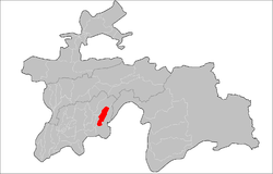 | |
 Mu'minobod District Mu'minobod District Location in Tajikistan | |
| Coordinates: 38°06′32.3″N 70°01′37.9″E / 38.108972°N 70.027194°ECoordinates: 38°06′32.3″N 70°01′37.9″E / 38.108972°N 70.027194°E | |
| Country |
|
| Province | Khatlon |
| Capital | Mu'minobod |
| Area | |
| • Land | 2,387 km2 (922 sq mi) |
| Population (2010) | |
| • Total | 72 300 |
| • Ethnicities |
|
| • Languages | Tajik-Persian |
| Website | tj |
Mu'minobod District or Nohiya-i Mu'minobod (Tajik: Ноҳияи Мӯъминобод) is a district in Khatlon province, Tajikistan. Its capital is Mu'minobod, in Soviet times, from 1973 − 1997, known as Leningradskiy.
Geography
This district is situated in the mountainous southeastern part of Khatlon, Kulob region, and is bordering Afghanistan. The district spans 2,387 square kilometers, and consists of five jamoats.[1]
History
The district was established in 1973 within Kulob.[2]
Subdivisions
The Mu'minobod District is divided into 7 Jamoats:[3]
| (Jamoats) Parts of Mu'minobod District [4] | ||||||||||||
| Parts | Population | No. of villages | ||||||||||
|---|---|---|---|---|---|---|---|---|---|---|---|---|
| Dehbaland | 11470 | |||||||||||
| Kulchashma | 17086 | |||||||||||
| Bogai | 7961 | |||||||||||
| Tutu | 7279 | |||||||||||
| Balhobi | 8315 | |||||||||||
| Childukhtaron | ||||||||||||
| Leningrad | 11131 | |||||||||||
| Capital |  | |
|---|---|---|
| Districts | ||
| Main cities and towns | ||
References
- ↑ Historical Dictionary of Tajikistan, Dushanbe, 2010, p. 245
- ↑ Historical Dictionary of Tajikistan, Dushanbe, 2010, p. 245
- ↑ "List of Jamoats". UN Coordination, Tajikistan. Archived from the original on July 16, 2011. Retrieved March 5, 2011.
- ↑ http://www.undp.tj/files/maps/JCP/Tajik_pdf/Local_Governance/Khatlon/LG4.3.pdf
This article is issued from
Wikipedia.
The text is licensed under Creative Commons - Attribution - Sharealike.
Additional terms may apply for the media files.