Mowe Lake
| Mowe Lake | |
|---|---|
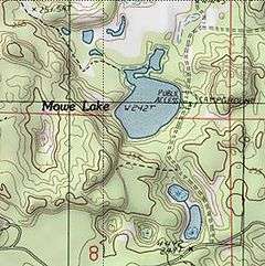
 A topographic map of the Mowe Lake area | |
| Location | Delta County, Michigan |
| Coordinates | 46°8′39.30″N 86°34′40.18″W / 46.1442500°N 86.5778278°WCoordinates: 46°8′39.30″N 86°34′40.18″W / 46.1442500°N 86.5778278°W |
| Basin countries | United States |
| Surface area | 24 acres (10 ha) |
| Surface elevation | 791 ft (241 m)[1] |

Mowe Lake
Mowe Lake is a 24-acre (10 ha) lake that is located in northern Delta County, Michigan in the Hiawatha National Forest.[2] It is just south of the county line with Alger and Schoolcraft countries and about a half mile north of trail 2225 on trail 2692 (commonly referred to as Mowe Lake Road) passed the small ponds. There are primitive campsites and a small boat launch.[2] Other nearby lakes include Hugaboom Lake, Blue Lake, Corner-Straits Chain of lakes, Ironjaw Lake, and Round Lake.
See also
References
- ↑ U.S. Geological Survey Geographic Names Information System: Mowe Lake
- 1 2 "Fishing Hiawatha National Forest". U.S.D.A. Forest Service. Retrieved 2008-11-29.
This article is issued from
Wikipedia.
The text is licensed under Creative Commons - Attribution - Sharealike.
Additional terms may apply for the media files.