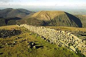
Mourne Wall
Coordinates: 54°08′20″N 6°00′11″W / 54.139°N 6.003°W

The Mourne Wall is a wall constructed to enclose a catchment area in the Mourne Mountains, Northern Ireland. It was built between 1904 and 1922 by the Belfast Water Commissioners to enclose a reservoir.
Background
Luke Livingstone Macassey (1843–1908), an Irish civil engineer and barrister, was in 1874 appointed consultant hydraulic engineer by the Belfast and District Water Commissioners. The Commission had been set up in 1840 to ensure the water supply for Belfast, at that time an expanding city. In 1891 Macassey advised the construction of a reservoir in the Mourne Mountains, as a long-term solution.[1]
The project required the acquisition of wayleaves and water rights. Private Acts of Parliament were passed, of 1893, 1897 and 1899, on behalf of the Commissioners.[2]
The Silent Valley Reservoir was created to hold the water in the catchment area, and supply Belfast. The main purpose of the Mourne Wall to isolate the catchment area from cattle and sheep. It is currently owned and maintained by Northern Ireland Water.[3]
Construction and course of the wall
The wall was crafted from natural granite stone using traditional dry stone walling techniques. On average the wall is about 1.5 metres (4 ft 11 in) high and 0.8 to 0.9 metres (2 ft 7 in to 2 ft 11 in) thick. It is 22 miles (35 km) long and passes over fifteen mountains (listed clockwise from the Kilkeel River):
- Slievenaglogh 445 m (1,460 ft)
- Slieve Muck 674 m (2,211 ft)
- Carn Mountain 587 m (1,926 ft)
- Slieve Loughshannagh 619 m (2,031 ft)
- Slieve Meelbeg 708 m (2,323 ft)
- Slieve Meelmore 684 m (2,244 ft)
- Slieve Bearnagh 727 m (2,385 ft)
- Slievenaglogh 586 m (1,923 ft)
- Slieve Corragh 691 m (2,267 ft)
- Slieve Commedagh 765 m (2,510 ft)
- Slieve Donard 850 m (2,790 ft)
- Rocky Mountain 525 m (1,722 ft)[4]
- Slieve Binnian 747 m (2,451 ft)
- Wee Binnian 460 m (1,510 ft)
- Moolieve 332 m (1,089 ft)
References
- ↑ "Luke Livingstone Macassey (1843–1908): Engineer and Barrister, The Dictionary of Ulster Biography". Retrieved 23 July 2017.
- ↑ "Your Place And Mine - Down - A Century of Water from the Mournes - a concise history". BBC Online. Retrieved 23 July 2017.
- ↑ "The Mournes" Ordnance Survey of Northern Ireland, 2005
- ↑ Rocky Mountain is the only peak for which the Wall skirts the lower slopes, rather than passing over or close by the summit.
- The Mountains of Mourne, A Celebration of a Place Apart, David Kirk, 2002, Appletree Press Ltd, Belfast
External links
- Photos, maps and commentary of the walk around the Wall
- Photos from Annadale Mountaineering Club trips to the Mournes including the Wall
- The Classic Walks of Ireland - The Mourne Wall. An account of a walk of the Mourne Wall
| Wikimedia Commons has media related to Mourne Wall. |