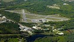
Moore Army Airfield
| Moore Army Airfield | |||||||||||||||||||||||||||
|---|---|---|---|---|---|---|---|---|---|---|---|---|---|---|---|---|---|---|---|---|---|---|---|---|---|---|---|
|
Moore Army Airfield May 2017 | |||||||||||||||||||||||||||
| Summary | |||||||||||||||||||||||||||
| Airport type | Army Airfield, Defunct | ||||||||||||||||||||||||||
| Operator | United States Army | ||||||||||||||||||||||||||
| Location | Fort Devens, Ayer / Shirley, Massachusetts | ||||||||||||||||||||||||||
| Built | 1929 | ||||||||||||||||||||||||||
| In use | 1929–1995 | ||||||||||||||||||||||||||
| Occupants | Army, Navy | ||||||||||||||||||||||||||
| Elevation AMSL | 256 ft / 78 m | ||||||||||||||||||||||||||
| Coordinates | 42°34′18″N 071°36′12″W / 42.57167°N 71.60333°W | ||||||||||||||||||||||||||
| Runways | |||||||||||||||||||||||||||
| |||||||||||||||||||||||||||
Moore Army Airfield is located in Fort Devens, Massachusetts. It was closed following the closure of the fort in 1995. It is named for Ayer native Chief Warrant Officer 2 Douglas Moore. It was the only Army Airfield named for someone killed in the Vietnam War.
History
Beginnings
The earliest information concerning the construction of the airfield dates to 1 July 1926. It was originally known as Ayer (Camp Devens) Emergency Field. The sod airfield's dimensions were: 2,300 by 850 feet (700 m × 260 m). It also ran northwest/southeast. Camp Devens Airfield, as it was called later, was operated by the Army. A second runway was extablished the following year. Approximate dimensions were said to be 2,325 by 1,560 feet (709 m × 475 m). In 1934, it was marked as an auxiliary airfield to the Navy.
World War II
When the nearby fort was expanded in 1940, the airport supposedly "gained" its own airfield. It was described as having a 5,200-foot (1,600 m) runway. In 1944, the army withdrew from the airfield and it became known as Naval Auxiliary Air Facility Ayer, which supported training operations at Squantum Naval Air Station. Carrier Air Groups 4 and 83 were at Ayer in 1944. The nearby Naval Auxiliary Air Facility Beverly was used as a bounce field.[1]
Postwar years
The Navy discontinued their use of Ayer NAAS for unknown reasons between the years of 1944–1946. Fort Devens was deactivated as part of demobilization, in 1946, but it was reopened in 1948. By 1954, it was known as Ayer AAF. Then it was renamed Fort Devens AAF between 1954 and 1959. It had three operating runways but they were used intermittently on and off throughout the years. The longest runway was listed in 1960 as being 3,745 feet (not including overrun). In the 1970s it got an upgraded control tower and it was used for helicopter operations. The air traffic controllers worked in conjunction with their counterparts at the nearby Hanscom AFB. Around 1976 the field was renamed Moore Army Airfield.[1]
Closure and Redevelopment
The field was closed around 1995 after the Army left. It is now a State Police driver training facility on week days. On weekends the runways are currently the largest and only centrally located venue in southern New England for SCCA Solo II style autocross competitions.[2] Several other clubs also use the runways for similar competitions. [3] [4][5][6][7][8] There is now talk of putting an industrial park over the runways of Moore Army Airfield.[1]
Groups Hosted
- 152nd Observation Squadron (1941–1943)
- Carrier Air Group 4
- Carrier Air Group 83
- 10th Special Forces Group (Minus the First Battalion) (1968–1995)
Aircraft Hosted
- Aeronca L-16
- R-16/H-16 - Piasecki
- North American BC-1
- North American O-47
- O-49
- O-52 Owl
- O-58
- HU-21 Workhorse/Shawnee
- U-10D Super Courier
- UH-1 Huey
- C-45 Expeditor
- C-130 Hercules
- C-12 Huron
- UH-60 Blackhawk
See also
References
- 1 2 3 Abandoned & Little-Known Airfields: Central Massachusetts
- ↑ New England Region SCCA Solo II
- ↑ ne-svt
- ↑ BMWCCA-Boston autocross
- ↑ Renegade Miata Club
- ↑ Bay State Corvette Club schedule
- ↑ New England Region Porsche Club
- ↑ North Country Porsche Club
External links
- Moore Army Airfield at GlobalSecurity.org

