Bute, South Australia
| Bute South Australia | |||||||||||||||
|---|---|---|---|---|---|---|---|---|---|---|---|---|---|---|---|
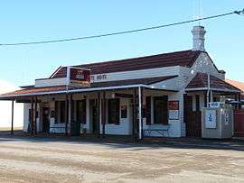 Bute Hotel | |||||||||||||||
 Bute | |||||||||||||||
| Coordinates | 33°51′0″S 138°00′0″E / 33.85000°S 138.00000°ECoordinates: 33°51′0″S 138°00′0″E / 33.85000°S 138.00000°E | ||||||||||||||
| Population | 268 (2006 census)[1] | ||||||||||||||
| Established | 1884[2] | ||||||||||||||
| Postcode(s) | 5560[3] | ||||||||||||||
| Location | |||||||||||||||
| LGA(s) | Barunga West | ||||||||||||||
| State electorate(s) | Frome | ||||||||||||||
| Federal Division(s) | Grey | ||||||||||||||
| |||||||||||||||
Bute is a town in the Mid North of South Australia, approximately 40 kilometres (25 mi) east of Wallaroo and 24 kilometres west of Snowtown. It was proclaimed as a town in 1884[2] and named after the Isle of Bute, in the Firth of Clyde, Scotland.[4] It was the original site of the Yorke Peninsula Field Days in 1895; they are now held outside Paskeville.[2]
Attractions
Attractions to the town include the nearby Bute tannery,[2] Bute Hobbies Bromeliad Display Gardens and the Bute Hotel.[5] A free-to-view fauna park on the Snowtown Road is maintained by the Bute Lions Club. Visitors can view emus, peacocks, waterfowl, red kangaroos and other wildlife contained within fenced enclosures.[6] The park also features barbecue facilities and picnic areas.[7] The town is surrounded by agricultural and pastoral land.
Railways
Bute is situated on the disused Brinkworth–Kadina railway line. This line was originally narrow gauge (1067mm) but was converted to broad gauge (1600mm) in 1927.[8] From the late 1990s until 2009 a tourist train traversed the line from Wallaroo to Bute.[9] The next siding towards Kadina on the railway was originally called "16-mile Siding" and later Mona, but is now included in the bounded Locality of Bute.[10]
References
- ↑ Australian Bureau of Statistics (25 October 2007). "Bute (Urban Centre/Locality)". 2006 Census QuickStats. Retrieved 2008-10-23.
- 1 2 3 4 "Bute, Yorke Peninsula, South Australia, Australia". Retrieved 2010-01-16.
- ↑ "Bute". Gazetteer of Australia online. Geoscience Australia, Australian Government.
- 1 2 "Bute, South Australia". Travelmate. Retrieved 2010-01-16.
- ↑ "Attractions for Bute - South Australia, Australia". Retrieved 2010-01-16.
- ↑ "Bute Lions Fauna Park | Bute Things to Do". www.about-australia.com. Retrieved 2017-06-25.
- ↑ West, District Council of Barunga (2015-07-29), Bute Fauna Park, District Council of Barunga West, retrieved 2017-06-25
- ↑ Callaghan, W. H. (2002), "Horse and Steam, Wheat and Copper", Australian Railway Historical Society Bulletin (January/February): 9–27, 46–63
- ↑ "Yorke Peninsula Rail". Lions Club of Yorke Peninsula Rail Inc. Archived from the original on 6 October 2008. Retrieved 2008-10-05.
- ↑ "Placename Details: Mona Railway Station". Land Services, Government of South Australia. 8 September 2008. SA0045570. Retrieved 26 February 2016.
Gazetted as 'Allotments at 16 mile siding'-vide Government Gazette 17/12/1885. Government Town declared ceased to exist on 25/1/1979. Now incorporated into the bounded locality of Bute.
External links
| Wikimedia Commons has media related to Bute, South Australia. |
| Major Townships | |||||||
|---|---|---|---|---|---|---|---|
| Minor Townships | |||||||
| Governance |
| ||||||
| Coastal features | |||||||
| Protected areas |
| ||||||
| Islands adjoining the Yorke Peninsula coast | |||||||
| Related and uncategorised | |||||||
| |||||||