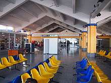
Moi International Airport
| Moi International Airport | |||||||||||||||
|---|---|---|---|---|---|---|---|---|---|---|---|---|---|---|---|
 | |||||||||||||||
| Summary | |||||||||||||||
| Airport type | Public, Civilian | ||||||||||||||
| Operator | Kenya Airports Authority | ||||||||||||||
| Serves | Mombasa | ||||||||||||||
| Location | Mombasa, Kenya | ||||||||||||||
| Elevation AMSL | 200 ft / 61 m | ||||||||||||||
| Coordinates | 04°02′24″S 39°35′24″E / 4.04000°S 39.59000°E | ||||||||||||||
| Website | |||||||||||||||
| Map | |||||||||||||||
 MBA Location of Moi International Airport in Kenya | |||||||||||||||
| Runways | |||||||||||||||
| |||||||||||||||
| Statistics (2013) | |||||||||||||||
| |||||||||||||||
Moi International Airport (IATA: MBA, ICAO: HKMO), is the international airport of Mombasa, the second-biggest city in Kenya. It is located in Mombasa County, in a township called Port Reitz and features regional as well as intercontinental flights.
Overview
Moi International Airport serves the city of Mombasa and surrounding communities. It lies approximately 425 kilometres (264 mi), by air, southeast of Jomo Kenyatta International Airport, the largest and busiest airport in the country.[2] Mombasa Airport is operated by Kenya Airports Authority. It was named after former Kenyan President Daniel arap Moi during his tenure.
At 61 metres (200 ft) above sea level,[3] the airport has two runways: Runway 1 measures 3,350 metres (10,990 ft) in length and Runway 2 measures 1,260 metres (4,130 ft) in length.[4] Runway 1 is also known as Runway 03/21, while Runway 2 is also known as Runway 15/33. Runway 1 is equipped with an ILS (Instrument Landing System).
There are two terminals at the airport.
History
The airport was built during the Second World War by the Engineer Corps of the South African Army. During that war it was used by the Fleet Air Arm as a land base of the British Eastern Fleet which was based at nearby Kilindini Harbour from 1942, by the Royal Air Force (AHQ East Africa and No. 246 Wing RAF) which operated anti-submarine Catalina flying boats off the East Africa coast and by the South African Air Force which was engaged in the war against Italy in Abyssinia. It was originally known as Port Reitz Airport.
Mombasa Airport was expanded to an international airport in 1979. Aircraft Maintenance facilities for private and light- to medium-size commercial aircraft are provided from government and private hangars by Benair Aircraft Engineering, licensed by the Kenya Civil Aviation Authority (KCAA) as an approved maintenance organisation (AMO).
From July to September 1994, Moi International Airport was used almost continuously as a refuelling station during the Operation Support Hope humanitarian mission into Rwanda. Empty C-141 and C-5 freighter jets returning to Europe flew to Mombasa due to the scarcity of fuel in the African interior. The airlift through Mombasa ceased by October due to runway expansion work.
Airlines and destinations


| Airlines | Destinations |
|---|---|
| Bravo Airways | Seasonal charter: Kiev-Zhuliany |
| Condor | Frankfurt Seasonal: Munich[5] |
| Enter Air | Seasonal: Larnaca, Warsaw-Chopin |
| Ethiopian Airlines | Addis Ababa |
| Fly540 | Nairobi–Jomo Kenyatta, Zanzibar |
| Fly-SAX | Moroni |
| Jambo Jet | Nairobi–Jomo Kenyatta |
| Kenya Airways | Jeddah, Nairobi–Jomo Kenyatta |
| Meridiana | Milan–Malpensa, Rome–Fiumicino |
| Mombasa Air Safari | Amboseli, Keekorok, Lamu, Malindi, Masai Mara, Ukunda/Diani Beach |
| Neos | Seasonal charter: Bologna, Milan–Malpensa, Rome–Fiumicino |
| RwandAir | Dubai–International, Kigali |
| Turkish Airlines | Istanbul–Atatürk1 |
Note
1: Turkish Airlines' inbound flights from Istanbul to Mombasa make a stop in Kilimanjaro. However, the airline does not have traffic rights to transport passengers solely between Kilimanjaro and Mombasa.
References
- ↑ "sadimsolutions.com » Kenyan airports passenger traffic declines by 5% 2013". sadimsolutions.com. Retrieved 21 December 2015.
- ↑ "Distance between Mombasa () (Airport) and Jomo Kenyatta Airport Nairobi (Nairobi Area) (Kenya)". GlobeFeed.com. Retrieved 16 February 2014.
- ↑ "Mombasa – Moi International Airport (MBA)". AirGorilla. Retrieved 16 February 2014.
- ↑ "Mombasa - Moi Int´l Airport (MBA/HKMO)". Virtual Globetrotting. Retrieved 21 December 2015.
- ↑ airliners.de (German) retrieved 23 June 2015
External links
![]() Media related to Moi International Airport at Wikimedia Commons
Media related to Moi International Airport at Wikimedia Commons
- Location of Moi International Airport At Google Maps
- Kenya Airports Authority – Moi International Airport
- Accident history for MBA at Aviation Safety Network – Mombasa Airport
Coordinates: 4°02′24″S 39°35′24″E / 4.040000°S 39.59000°E