Modifiable areal unit problem

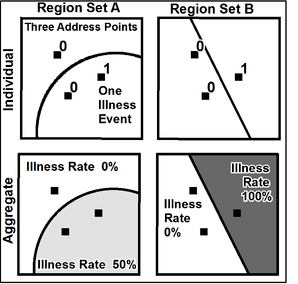
The modifiable areal unit problem (MAUP) is a source of statistical bias that can significantly impact the results of statistical hypothesis tests. MAUP affects results when point-based measures of spatial phenomena are aggregated into districts, for example, population density or illness rates. The resulting summary values (e.g., totals, rates, proportions, densities) are influenced by both the shape and scale of the aggregation unit.[1]
For example, census data may be aggregated into county districts, census tracts, postcode areas, police precincts, or any other arbitrary spatial partition. Thus the results of data aggregation are dependent on the mapmaker's choice of which "modifiable areal unit" to use in their analysis. A census choropleth map calculating population density using state boundaries will yield radically different results than a map that calculates density based on county boundaries. Furthermore, census district boundaries are also subject to change overtime,[2] meaning the MAUP must be considered when comparing past data to current data.
Background
The issue was recognized in 1934[3] and later described in detail by Stan Openshaw, who lamented that "the areal units (zonal objects) used in many geographical studies are arbitrary, modifiable, and subject to the whims and fancies of whoever is doing, or did, the aggregating."[4]
See also
General topics
Specific applications
Notes
- ↑ "MAUP | Definition - Esri Support GIS Dictionary". support.esri.com. Retrieved 2017-03-09.
- ↑ Geography, US Census Bureau. "Geographic Boundary Change Notes". www.census.gov. Retrieved 2017-02-24.
- ↑ Gehlke & Biehl 1934
- ↑ Openshaw 1983, p. 3
References
- Gehlke, C. E.; Biehl, Katherine (March 1934). "Certain effects of grouping upon the size of the correlation coefficient in census tract material". Journal of the American Statistical Association. 29 (185A): 169–170. doi:10.2307/2277827.
- Openshaw, Stan (1983). The modifiable areal unit problem. Norwick: Geo Books. ISBN 0860941345. OCLC 12052482.
Further reading
- Cressie, Noel A (1996). "Change of support and the modifiable areal unit problem". Geographical Systems. 3 (2–3): 159–180.
- Holt, David; Steel, David; Tranmer, Mark; Wrigley, Neil (July 1996). "Aggregation and ecological effects in geographically based data" (PDF). Geographical Analysis. 28 (3): 244–261. doi:10.1111/j.1538-4632.1996.tb00933.x.
- Horner, Mark W.; Murray, Alan T. (January 2002). "Excess commuting and the modifiable areal unit problem" (PDF). Urban Studies. 39 (1): 131–139. doi:10.1080/00420980220099113.
- Kwan, Mei-Po (2012). "The uncertain geographic context problem" (PDF). Annals of the Association of American Geographers. 102 (5): 958–968. doi:10.1080/00045608.2012.687349.
- Menon, Carlo (March 2012). "The bright side of MAUP: defining new measures of industrial agglomeration" (PDF). Papers in Regional Science. 91 (1): 3–28. doi:10.1111/j.1435-5957.2011.00350.x.
- Unwin, David J (December 1996). "GIS, spatial analysis and spatial statistics" (PDF). Progress in Human Geography. 20 (4): 540–551. doi:10.1177/030913259602000408.
- Wong, David (2009). "The modifiable areal unit problem (MAUP)". In Fotheringham, A Stewart; Rogerson, Peter. The SAGE handbook of spatial analysis. Los Angeles: Sage. pp. 105–124. ISBN 9781412910828. OCLC 85898184.
- Wrigley, Neil (1995). "Revisiting the modifiable areal unit problem and the ecological fallacy". In Cliff, Andrew D. Diffusing geography: essays for Peter Haggett. The Institute of British Geographers special publications series. 31. Oxford; Cambridge, MA: Blackwell. pp. 123–181. ISBN 0631195343. OCLC 30895028.
- Zhang, Ming; Kukadia, Nishant (January 2005). "Metrics of urban form and the modifiable areal unit problem". Transportation Research Record: Journal of the Transportation Research Board. 1902: 71–79. doi:10.3141/1902-09.