Province No. 2
| Province No. 2 | |
|---|---|
 | |
| Country |
|
| Area | |
| • Total | 9,661 km2 (3,730 sq mi) |
| Population | |
| • Total | 5,404,145 |
| Time zone | Nepal Time (UTC+5:45) |
| Geocode | NP-TW |
| Main language | Maithili |
Province No. 2 is the provisional designation of one of the provinces established in southeastern Nepal by the Constitution of Nepal, which was adopted on 20 September 2015.[1] It is the province with majority of Maithili speaking population of Nepal, including total eight districts bordering from current Parsa District to Saptari District of Nepal.[1] The official name and headquarters of the province has not yet been decided. The Sub-Metropolitan City of Janakpur[2], also known as Janakpurdham, is a centre for religious and cultural tourism.[3] It is also thought to be the capital of the Videha dynasty that ruled Mithila region in ancient times.[4] The metropolitan city of Birgunj[5] is an economically important industrial centre and the only metropolitan city in this province.[6] It is a candidate for the province's capital.[7][8][9][10]
Districts
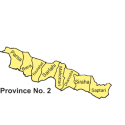
The province comprises the following districts:
- Bara District
- Dhanusha District
- Mahottari District
- Parsa District
- Rautahat District
- Saptari District
- Sarlahi District
- Siraha District
Geography
The region is surrounded by:[11]
- The Sunsari District of Province No. 1 to the East.
- The Chitwan District of Province No. 3 to the West.
- The Makwanpur District and Sindhuli District of Province No. 3 and Udayapur District of Province No. 1 to the North.
- The international border with India to the South.
As per Central Bureau of Statistics(CBS)[12] the province covers about 9,661 km2 (3,730 sq mi). of Nepal's total area of 147,181 km2 (56,827 sq mi). with total number of 5,404,145 inhabitants, it is by far the second most populous of the new provinces after Province No. 3.[1] [13]
Roadways
Janakpurdham lies 25 kilometres (16 mi) south of the East-West Highway.[14] At its eastern end this road joins an Tribhuvan Highway that connects it to Kathmandu, the capital city of the country and Pokhara.[15] At its western end it enters the Lumbini state of the country which further links to Nepalgunj and Birgunj, the industrial states of Nepal.[14] The Mahendra (East-West) Highway is the longest in the country, at 1,000 kilometres (620 mi).[14] The Tribhuvan Highway does not cross as much of the province no. 2 of Nepal as the Mahendra Highway, but it is equally important as it connects the province to Kathmandu, the capital of Nepal, on one side and to the Indian states of Bihar and Uttar Pradesh on the other side.[16]
Railways
A few other railway projects are under progress in the province no. 2. All these projects are of Nepal Railways. Government of Nepal has proposed Janakpur as a Main Station for 1024 km east-west Metro Railway project and further be extended to India and China for connecting Nepal Railways with Indian Railways and China Railways for business and tourism promotion.[17]
- Janakpur (Nepal) to Lhasa (China)
- Bardibas, Janakpur (Nepal) to Jainagar, Bihar (India)
- Janakpur (Nepal) to Kathmandu (Nepal)
- Janakpur (Nepal) to Biratnagar (Nepal)
- Janakpur (Nepal) to Nepalgunj (Nepal)
- Janakpur (Nepal) to Birgunj (Nepal)
Airways
Province No. 2 has 3 airports:
- Rajbiraj Airport(Not in use) , in Rajbiraj
- Janakpur Airport in Janakpur.
- Simara Airport in Pipara Simara close to Birganj.
- Nijgadh International Airport in Bara district.
See also
- Federal Democratic Republic of Nepal
- Administrative divisions of Nepal
- List of districts of Nepal
- Nepalese Federal States
- Province No. 1
- Province No. 3
- Province No. 4
- Province No. 5
- Province No. 6
- Province No. 7
References
- 1 2 3 "Nepal Provinces". statoids.com. Retrieved 2016-03-21.
- ↑ "Janakpur Sub-Metropolitan City official Website".
- ↑ Rastriya Samachar Samiti (2004). "More Indian tourists visit Janakpurdham". Himalayan Times, 17 January 2004.
- ↑ Burghart, R. (1978). The disappearance and reappearance of Janakpur. Kailash: A Journal of Himalayan Studies 6 (4): 257–284.
- ↑ "Birgunj Metropolitan City official Website". birgunjmun.gov.np.
- ↑ "Biratnagar, Birgunj promoted to Metropolitan Cities". The Himalayan Times. 1 June 2017. Retrieved 25 June 2017.
- ↑ "Possible headquarters of states". onlinekhabar.com.
- ↑ "Where will Province Chief live?". Naya Patrika Nepal's National News.
- ↑ "possible Province headquarters". BroadNepal News Bnn.
- ↑ "कुन प्रदेशको राजधानी कहाँ ?". Himalayan Kangaroo.
- ↑ "Big 3 draw new 7-province map". Republica. 22 Aug 2015. Retrieved 26 June 2017.
- ↑ "Statistical Year Book 2015 by CBS Nepal". Central Bureau of Statistics(CBS). Retrieved 26 June 2017.
- ↑ "The population of the provinces of Nepal according to census results and latest official projections.". City Population. 29 Dec 2015. Retrieved 26 June 2017.
- 1 2 3 David Reed, James McConnachie. The rough guide to Nepal. Nepalganj p. 361, Mahendranagar p. 374, Janakpur p. 388, Kankarbhitta p. 400, Itahar p. 442. Google book. Retrieved 2010-05-18.
- ↑ Woodhatch, Tom. Nepal handbook. Western Nepal p. 29, Junctions p. 44, Length p. 238, Overview p. 373, Nepalganj p. 394 -398, Terai east of Sapt Kosi p. 401, Janakpur p. 436, Eastern Nepal p. 450,. Google books. Retrieved 2012-05-09.
- ↑ Highways in Nepal
- ↑ Nepal,India agree on five rail projects
 | ||