Minlaton, South Australia
| Minlaton South Australia | |||||||||||||||
|---|---|---|---|---|---|---|---|---|---|---|---|---|---|---|---|
 War memorial on Main St. | |||||||||||||||
 Minlaton | |||||||||||||||
| Coordinates | 34°46′17″S 137°35′44″E / 34.77139°S 137.59556°ECoordinates: 34°46′17″S 137°35′44″E / 34.77139°S 137.59556°E | ||||||||||||||
| Population | 773 (2006 census)[1] | ||||||||||||||
| Established | 1876[2] | ||||||||||||||
| Postcode(s) | 5575 | ||||||||||||||
| Location | |||||||||||||||
| LGA(s) | Yorke Peninsula Council | ||||||||||||||
| Region | Yorke and Mid North[3] | ||||||||||||||
| County | Fergusson[2] | ||||||||||||||
| State electorate(s) | Goyder[4] | ||||||||||||||
| Federal Division(s) | Grey[5] | ||||||||||||||
| |||||||||||||||
| Footnotes | Adjoining localities[2] | ||||||||||||||
Minlaton is a town in central Yorke Peninsula, South Australia. At the 2006 census, Minlaton had a population of 773.[1] It is known as the "Barley capital of the world", due to the rich Barley production in the region.
Minlaton was the home town of Harry Butler, a World War I flying ace. His Bristol M1C monoplane has been restored and is preserved in pride of place in a building the centre of the town. When he flew an air mail run from Adelaide across Gulf St Vincent to Minlaton in 1919, it was the first over-water flight in the Southern Hemisphere.
Minlaton is in the District Council of Yorke Peninsula, the federal Division of Grey[6] and the state electoral district of Goyder.[4]
Thirteen miles to the west is Brown Point, commonly known as "The Bluff" or "Bluff Beach", where the boat winching system is a tourist attraction.
Gallery
 Harry Butler's Red Devil is on display in Minlaton
 Harry Butler memorial
 Main street
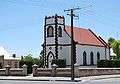 St Benedict's Anglican church, built in 1886
See also
References
- 1 2 Australian Bureau of Statistics (25 October 2007). "Minlaton (L) (Urban Centre/Locality)". 2006 Census QuickStats. Retrieved 2010-01-22.
- 1 2 3 "Search result(s) for Minlaton (LOCB) (Record No. SA0045172) with the following layers being selected - "Suburbs and Localities", "Counties", "Hundreds", "Place names (gazetteer)" and "Road labels"". Property Location Browser. Government of South Australia. Archived from the original on 12 October 2016. Retrieved 29 April 2017.
- ↑ "Yorke and Mid North SA Government region" (PDF). The Government of South Australia. Retrieved 28 April 2017.
- 1 2 "Goyder electorate boundaries as of 2014". ELECTORAL COMMISSION SA. Retrieved 23 July 2015.
- ↑ "Federal electoral division of Grey" (PDF). Australian Electoral Commission. Retrieved 24 July 2015.
- ↑ "Localities". Australian Electoral Commission. Retrieved 2010-07-13.
External links
| Wikimedia Commons has media related to Minlaton, South Australia. |
- Yorke Peninsula: Minlaton
- Harvest Corner website Yorke Peninsula Visitor Information Centre at Minlaton
| Major Townships | |||||||
|---|---|---|---|---|---|---|---|
| Minor Townships | |||||||
| Governance |
| ||||||
| Coastal features | |||||||
| Protected areas |
| ||||||
| Islands adjoining the Yorke Peninsula coast | |||||||
| Related and uncategorised | |||||||
| |||||||