Merula (creek)
| Merula | |
|---|---|
 Merula creek in Stellanello | |
 | |
| Country | Italy |
| Basin features | |
| Main source | Eastern slopes of Monte Torre (Ligurian Alps) |
| River mouth |
Ligurian Sea in Andora (SV, Italy) 0 m (0 ft) 43°56′54.87″N 8°08′40.42″E / 43.9485750°N 8.1445611°ECoordinates: 43°56′54.87″N 8°08′40.42″E / 43.9485750°N 8.1445611°E |
| Basin size | 49 km2 (19 sq mi)[1] |
| Physical characteristics | |
| Length | 14.7 km (9.1 mi)[1] |
The Merula is a 14.7-kilometre (9.1 mi) stream of Liguria (Italy).
Geography
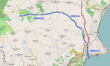
The creek is formed not faraway from the centre of Testico from the union of several streams descending the eastern slopes of Monte Torre (990 m)[2]. At first it flows down heading East and then turns South towards the Ligurian Sea. Close to its mouth, which is located in Marina di Anrora, the Marula is crossed by Autostrada dei Fiori, Genoa–Ventimiglia railway and State highway nr.1 (Via Aurelia).
Merula basin (49 km2) is totally included in the Province of Savona.[3]
Main tributaries
- Right hand:
- rio Moltedo
- rio Domo;
- left hand:
- rio Tigorella,
- rio Metta.
Nature conservation
On the mouth of the Merula was established a nature protected area of 2.6 ha managed by the comune of Andora[4] and called Oasi del Merula. Even if small this nature reserve is important because is one of the few wetlands available for water birds next to the Ligurian sea shore.[5]
References
- 1 2 PIANO DI BACINO STRALCIO SUL RISCHIO IDROGEOLOGICO, Provincia di Savona, on-line in pdf su www.provincia.savona.it (accesso: 2015-07-07)
- ↑ "Carta tecnica regionale su Limiti Amministrativi (Comunali, Provinciali, Regionali) sc. 1:25000". geoportale.regione.liguria.it. Regione Liguria. 2011.
- ↑ 1:25.000 map of the Istituto Geografico Militare, on-line on www.pcn.minambiente.it/viewer
- ↑ "Oasi del MERULA" (PDF). Provincia di Savona. Retrieved 2017-07-08.
- ↑ "La natura al centro di Andora". Comune di Andora. Retrieved 2017-07-08.
See also
![]() Media related to Merula at Wikimedia Commons
Media related to Merula at Wikimedia Commons