Bowen, Queensland
| Bowen Queensland | |||||||||||||||
|---|---|---|---|---|---|---|---|---|---|---|---|---|---|---|---|
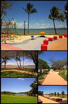 Top: Playground at Bowen Foreshore, Middle left: Bowen Foreshore, Middle right: Walkway along Santa Barbara parade, Bottom left: Muller's Lagoon, Bottom right: Bowen Skatebowl | |||||||||||||||
 Bowen | |||||||||||||||
| Coordinates | 20°01′0″S 148°14′0″E / 20.01667°S 148.23333°ECoordinates: 20°01′0″S 148°14′0″E / 20.01667°S 148.23333°E | ||||||||||||||
| Population | 10,260 (2011 census)[1] | ||||||||||||||
| • Density | 5.8009/km2 (15.024/sq mi) | ||||||||||||||
| Postcode(s) | 4805 | ||||||||||||||
| Elevation | 5 m (16 ft) | ||||||||||||||
| Area | 1,768.7 km2 (682.9 sq mi) | ||||||||||||||
| Location |
| ||||||||||||||
| LGA(s) | Whitsunday Region | ||||||||||||||
| State electorate(s) | Burdekin | ||||||||||||||
| Federal Division(s) | Dawson | ||||||||||||||
| |||||||||||||||
| |||||||||||||||
Bowen is a coastal town and locality in the Whitsunday Region on the eastern coast of Queensland, Australia.[2][3] The town of Merinda and the Abbot Point coal shipping port are also within the locality of Bowen.[4][5] At the 2011 census, Bowen had a population of 8,604.[1]
Geography
Bowen is located on the north-east coast, in North Queensland, Australia, at exactly twenty degrees south of the equator. Bowen is halfway between Townsville and Mackay, and 1,130 kilometres (700 mi) by road from Brisbane.
Bowen sits on a square peninsula, with the Coral Sea to the north, east, and south. To the south-east is Port Denison.[6] On the western side, where the peninsula connects with the mainland, the Don River's alluvial plain provides fertile soil that supports a prosperous farming industry.
Merinda is a hinterland town 8 km west of Bowen.[7]
The Bruce Highway enters the locality from the east, approaches but does not enter the town of Bowen itself, but then turns west to pass through Merinda before exiting the locality to the north-west.[7] The North Coast railway line follows a similar route through the locality but enters the town of Bowen which is served by the Bowen railway station. At Merinda railway station, there is the junction with the Collinsville-Newlands railway line servicing the Bowen basin Coalfields.[8] The Collinsville-Newlands line extends to the coal-handling port at Abbot Point, also within the locality of Bowen. The railway station servicing the port is the Abbot Point railway station.[7][9]
In the west of the locality is the Mount Aberdeen National Park.[7]
Economy
The town enjoys a diversified and prosperous economy based on agriculture, fishing, tourism, and mining. Its unusually dry climate for a tropical location, plus its fertile alluvial soil, makes it the ideal place to grow a wide variety of small crops, including tomatoes, rockmelons (i.e., cantaloupes), and capsicums (i.e., green peppers). Outside the alluvial plain, much of the Bowen area is used for beef cattle.
Just north of Bowen is the Abbot Point coal loading port. Coal mined inland of Bowen in Collinsville and other towns in the Bowen Basin is brought by rail to a deepwater pier to be loaded on bulk carriers. Coal is exported mainly to China and India.
Government
In 1944 Bowen elected a Communist, Fred Paterson, to Queensland Legislative Assembly. He was re-elected in 1947, but lost the seat in 1950 when the boundaries were changed to include Bowen in the seat of Whitsunday.
Bowen was the administrative centre for the Shire of Bowen. On 15 March 2008, under the Local Government (Reform Implementation) Act 2007 passed by the Parliament of Queensland on 10 August 2007, the Shire of Bowen merged with the Shire of Whitsunday to form the Whitsunday Region.[10][11] Although Proserpine is the administrative centre for the new regional council, the council maintains offices in Bowen and holds a number of council meetings in Bowen each year.[12][13]
History

Discovery by Europeans
Captain James Cook named Cape Gloucester on his voyage of exploration up the Australian coast in 1770. This "cape" turned out to be an island, and Gloucester Island dominates the view from Bowen's eastern beaches. Behind the island is a bay that forms an excellent port, which the town came to be built around. This bay was eventually discovered in 1859 by Captain Henry Daniel Sinclair, in response to a reward offered by the colony of New South Wales for finding a port somewhere north of Rockhampton. Sinclair named Port Denison after the colonial governor of New South Wales, William Denison.
Establishment of the town
Two years later, George Elphinstone Dalrymple led an overland expedition from Rockhampton, complemented with a naval contingent to rendezvous at Port Denison and establish the settlement. Dalrymple planned this two pronged entry into the area because 'a sudden cooperation of land and sea forces..would either strike terror, which would result in immediate flight, or enable a blow to be struck' against the local aboriginals of which many had been seen camped around the harbour. To facilitate this plan, Dalrymple travelled with Lieut. Williams and 6 Native Police troopers, while Lieut. Powell and his troopers travelled on the ships. These ships were Jeannie Dove and the Santa Barbara under the command of Capt. McDermott. The maritime group arrived first and waited for Dalrymple's overland party by camping on Stone Island at the mouth of the harbour. Dalrymple's group, which included 140 horses and 121 cattle, arrived on 11 April 1861. He rode down to the area on the foreshore 'beside the native wells' (which was to be the water supply of the settlement) in order 'to clear off the aborigines from the same, should such be necessary' and to signal McDermott's group on Stone Island. The local aboriginals had already fled. The settlers on Stone Island then came over to the site and the town of Port Denison was founded. Dalrymple wrote that it was 'deeply gratifying to me to see the British flag flying over the spot where..a few days ago, the wild aboriginal held undisputed sway', and that the settlement marked 'the advance of another great wave of Anglo-Australian energy'.[14]
After Queensland had separated from New South Wales, and the town was re-named Bowen after the first Queensland colonial governor, Sir George Bowen. Port Denison Post Office opened in April 1861 and was renamed Bowen by 1865.[15]
Shipwrecks
In 1863, the new settlers discovered a sailor, James Morril, who had been shipwrecked 17 years previously just to the north of Bowen. Morril made his home in the new town, and his grave is still to be seen in the Bowen cemetery.
The coral reefs around Bowen have several shipwrecks, including the SS Gothenburg which sank in 1875 with a loss of more than 100 lives. Numerous relics of Bowen's history, from the Aboriginal past onwards, are on display at the Bowen Historical Society's museum.
Schools
Bowen State School opened in 1865. Between 1877 and 1922, it operated as two schools: Bowen Boys State School and Bowen Girls and Infants State School. A secondary department was added to Bowen State School in 1928. On 23 January 1961, the secondary department was replaced by Bowen State High School.[16]
St Mary's School was opened on 1 September 1872. Merinda Provisional School opened in 1898 and became Merinda State School on 1 January 1909. Queens Beach State School opened on 25 November 1940.[16]
World War 2
.jpg)
During World War 2 Bowen hosted an air force base, flying PBY Catalina flying boats to search for enemy ships and submarines. The concrete aprons and ramp are still present (2013), and silhouettes of two aircraft have been painted in.
Climate
The town is located in the dry tropics. It is noticeably drier than surrounding locations due to a rain shadow effect produced by the nearby Gloucester Island. Due to the town's latitude, the trade winds provide a pleasant breeze. The warmest month is January, with an average maximum temperature of 31 °C (88 °F). The coolest month is July, with an average maximum temperature of 25 °C (77 °F) and an average overnight minimum of 13 °C (57 °F).
| Climate data for Bowen | |||||||||||||
|---|---|---|---|---|---|---|---|---|---|---|---|---|---|
| Month | Jan | Feb | Mar | Apr | May | Jun | Jul | Aug | Sep | Oct | Nov | Dec | Year |
| Record high °C (°F) | 38.1 (100.6) |
39.4 (102.9) |
36.9 (98.4) |
35.2 (95.4) |
32.5 (90.5) |
30.0 (86) |
31.4 (88.5) |
31.5 (88.7) |
36.0 (96.8) |
35.7 (96.3) |
35.0 (95) |
38.1 (100.6) |
39.4 (102.9) |
| Average high °C (°F) | 31.5 (88.7) |
31.3 (88.3) |
30.7 (87.3) |
29.2 (84.6) |
27.0 (80.6) |
24.9 (76.8) |
24.5 (76.1) |
25.4 (77.7) |
27.4 (81.3) |
29.2 (84.6) |
30.4 (86.7) |
31.3 (88.3) |
28.6 (83.5) |
| Average low °C (°F) | 23.8 (74.8) |
23.8 (74.8) |
22.7 (72.9) |
20.8 (69.4) |
17.8 (64) |
14.8 (58.6) |
13.3 (55.9) |
14.2 (57.6) |
16.5 (61.7) |
19.8 (67.6) |
22.1 (71.8) |
23.4 (74.1) |
19.4 (66.9) |
| Record low °C (°F) | 17.7 (63.9) |
18.4 (65.1) |
16.5 (61.7) |
10.0 (50) |
6.9 (44.4) |
4.0 (39.2) |
4.2 (39.6) |
3.2 (37.8) |
6.4 (43.5) |
11.1 (52) |
14.6 (58.3) |
17.8 (64) |
3.2 (37.8) |
| Average rainfall mm (inches) | 176.5 (6.949) |
228.1 (8.98) |
121.1 (4.768) |
58.6 (2.307) |
43.6 (1.717) |
23.4 (0.921) |
20.4 (0.803) |
22.2 (0.874) |
11.0 (0.433) |
12.5 (0.492) |
53.7 (2.114) |
143.3 (5.642) |
914.4 (36) |
| Average rainy days (≥ 0.2mm) | 11.9 | 12.6 | 10.3 | 8.2 | 6.2 | 5.1 | 3.5 | 2.6 | 2.3 | 3.4 | 6.7 | 9.4 | 82.2 |
| Source: Bureau of Meteorology[17] | |||||||||||||
Television
Bowen is serviced by Six free to air channels. Bowen picks up regional affiliates and can possibly pick up Brisbane channels. The Brisbane channels are:
The regional affiliates are:
- Seven Queensland (STQ)
- WIN Television
- Southern Cross Nine
Foxtel is also available in the Bowen area
Heritage listings
Bowen has a number of heritage-listed sites, including:
- Flemington Road: Flemington Road Cemetery[18]
- 6 Herbert Street: Bowen Harbour Board Building[19]
- 46 Herbert Street: Bowen Post Office[20]
- 29 Kennedy Street: Bowen State School[21]
- 30 Williams Street: Bowen Courthouse[22]
Tourism

Bowen is on a peninsula, with ocean on three sides. This gives eight beaches surrounding the town, namely Kings Beach, Queens Beach, Horseshoe Bay, Murrays Bay, Greys Bay, Rose Bay, and the Front Beach. There is also the clothing-optional Coral Bay. Kings Beach offers views of nearby Gloucester Island. On the western half of Queens Beach and all of Kings Beach, it is permitted to walk a dog without a leash.
The Big Mango, costing $90,000 to create, was erected in 2002 as a tourist attraction at the Bowen Tourist Information Centre. In February 2014, the 10-metre high, seven-tonne fibreglass structure was stolen in an overnight operation.[23] The mango was found the next day and it was later revealed that the theft had been a publicity stunt.[24]
Australia
In December 2006, it was announced that Bowen was chosen as a filming location for a third of the production of Australia, directed by Baz Luhrmann and starring Nicole Kidman and Hugh Jackman, portraying the look of Darwin.[25] Bowen was chosen as a prospect due to the financing of $500,000 by the Queensland government.[26] The production moved to Bowen on 14 May 2007.[27]
When it was announced that Australia was to be filmed in Bowen, locals painted a large "Bowenwood" sign on an old water tank on top of a hill, in a parody of the world-famous Hollywood sign.
Entertainment
Bowen boasts a cinema, the Summergarden Twin Theatre, the Denison Hotel, the Queens Beach Hotel, the Central Hotel, the North Australian Hotel, the Commercial Hotel, Barnacles Backpackers and the Grand View Hotel. It also offers four motels and seven caravan parks. There is also a golf course that overlooks Queens Beach.
Education
Bowen State School is a government co-educational primary school (P-6) at 29 Kennedy Street. In 2015, it had an enrolment of 480 students with 34 teachers (30 full-time equivalent).[28]
Queens Beach State School is a government co-educational primary school (P-6) at 39 Tracey Street. In 2014 (when it was a P-7 school), it had an enrolment of 452 students with 32 teachers (30 full-time equivalent).[29]
Merinda State School is a government co-educational primary school (P-6) at Bergl Street. In 2015, it had an enrolment of 87 students with 7 teachers (5 full-time equivalent).[30]
St Mary's Catholic School is a Roman Catholic co-educational primary school (P-6) at 39 Poole Street. In 2015, it had an enrolment of 83 students.[31]
Bowen State High School is a government co-education secondary school (7-12) at 1-9 Argyle Park Road. In 2015, it had an enrolment of 657 students with 58 teachers (56 full-time equivalent).[32]
TAFE Queensland North is a government co-educational tertiary institute for vocational skills. Its Bowen campus is at 98-158 Queens Road. Before 2013, the Bowen campus was part of the Barrier Reef Institute of TAFE.[33]
Notable residents
- Sir Charles Newton Barton (1907 - 1987) commissioner of main roads and co-ordinator-general of public works.[34]
- Edith Bethel (1879 - 1929) political organiser.[35]
- Douglas James (Jim) Darwen (1906 - 1988) newspaper-owner and editor.[36]
Sister cities
See also
References
- 1 2 Australian Bureau of Statistics (31 October 2012). "Bowen (Urban Centre/Locality)". 2011 Census QuickStats. Retrieved 5 December 2012.

- ↑ "Bowen - town (entry 4104)". Queensland Place Names. Queensland Government. Retrieved 18 January 2017.
- ↑ "Bowen - locality (entry 49069)". Queensland Place Names. Queensland Government. Retrieved 18 January 2017.
- ↑ "Merinda - town in the Whitsunday Region (entry 21625)". Queensland Place Names. Queensland Government. Retrieved 29 July 2017.
- ↑ "Abbot Point - headland in the Whitsunday Region (entry 14)". Queensland Place Names. Queensland Government. Retrieved 29 July 2017.
- ↑ "Port Denison (entry 9741)". Queensland Place Names. Queensland Government. Retrieved 9 January 2016.
- 1 2 3 4 "Queensland Globe". State of Queensland. Retrieved 29 July 2017.
- ↑ "Merinda - railway station in Whitsunday Region (entry 21627)". Queensland Place Names. Queensland Government. Retrieved 29 July 2017.
- ↑ "Abbot Point - railway station in the Whitsunday Region (entry 15)". Queensland Place Names. Queensland Government. Retrieved 29 July 2017.
- ↑ "Agency ID349, Bowen Shire Council". Queensland State Archives. Retrieved 10 September 2013.
- ↑ "Agency ID11036, Whitsunday Regional Council". Queensland State Archives. Retrieved 10 September 2013.
- ↑ "Council opening times and locations | Whitsunday Regional Council". www.whitsunday.qld.gov.au. Retrieved 9 January 2016.
- ↑ "Council Meetings | Whitsunday Regional Council". www.whitsunday.qld.gov.au. Retrieved 9 January 2016.
- ↑ "PORT DENISON.". The North Australian, Ipswich And General Advertiser. VI, (359). Queensland, Australia. 7 June 1861. p. 4. Retrieved 22 July 2017 – via National Library of Australia.
- ↑ Premier Postal History. "Post Office List". Premier Postal Auctions. Retrieved 10 May 2014.
- 1 2 Queensland Family History Society (2010), Queensland schools past and present (Version 1.01 ed.), Queensland Family History Society, ISBN 978-1-921171-26-0
- ↑ "Bowen Airport". Climate statistics for Australian locations. Bureau of Meteorology. March 2014. Retrieved 27 March 2014.
- ↑ "Flemington Road Cemetery (entry 601487)". Queensland Heritage Register. Queensland Heritage Council. Retrieved 16 July 2013.
- ↑ "Bowen Harbour Board Building (former) (entry 600041)". Queensland Heritage Register. Queensland Heritage Council. Retrieved 16 July 2013.
- ↑ "Whitsunday Region Local Heritage Register: Bowen Post Office". Whitsunday Regional Council. Retrieved 29 May 2016.
- ↑ "Bowen State School (entry 602817)". Queensland Heritage Register. Queensland Heritage Council. Retrieved 16 July 2013.
- ↑ "Bowen Court House (entry 600044)". Queensland Heritage Register. Queensland Heritage Council. Retrieved 16 July 2013.
- ↑ Silva, Kristian (24 February 2014). "Big Mango stolen from Bowen". The Land. Retrieved 2 March 2014.
- ↑ Ironside, Robyn (25 February 2014). "Big Mango tourist attraction stolen from Bowen has been found". The Courier Mail. Retrieved 2 March 2014.
- ↑ "Luhrmann epic to be shot in Bowen". The West Australian. 12 December 2006. Retrieved 28 April 2007.
- ↑ Des Partridge; Rosanne Barrett (13 December 2006). "Grant lures Baz". The Courier-Mail. Retrieved 29 April 2007.
- ↑ Rachel Browne (16 April 2007). "Other Tom gives Nic saddle tips". The Age. Melbourne. Retrieved 29 April 2007.
- ↑ "2015 School Annual Report" (PDF). Bowen State School. Retrieved 18 January 2017.
- ↑ "2014 School Annual Report" (PDF). Queens Beach State School. Retrieved 18 January 2017.
- ↑ "2015 School Annual Report" (PDF). Merinda State School. Retrieved 18 January 2017.
- ↑ "School Reporting 2015" (PDF). Diocese of Townsville Catholic Education. Retrieved 18 January 2017.
- ↑ "2015 School Annual Report" (PDF). Bowen State High School. Retrieved 18 January 2017.
- ↑ "Bowen - TAFE, Queensland". TAFE North Queensland. Retrieved 18 January 2017.
- ↑ "Sir Charles Newton Barton (1907 - 1987)". Australian Dictionary of Biography. 2007. Retrieved 30 March 2015.
- ↑ "Bethel, Edith (1871–1929)". Australian Dictionary of Biography. 2005. Retrieved 30 March 2015.
- ↑ "Darwen, Douglas James (Jim) (1906–1988)". Australian Dictionary of Biography. 2007. Retrieved 30 March 2015.
- ↑ "Bowen and Collinsville" (PDF). Tourism Bowen. p. 14. Retrieved 18 August 2016.
Further reading
- Gordon, James (1859), How Bowen was discovered : the cruise of the Santa Barbara, 9 tons, in search of a northern port in the year 1859, [s.n, retrieved 17 January 2016 — full text available online via the National Library of Australia
External links
| Wikimedia Commons has media related to Bowen, Queensland. |
- University of Queensland: Queensland Places: Bowen
- http://www.tourismbowen.com.au/
- https://web.archive.org/web/20031222233712/http://www.dpi.qld.gov.au/rlq/4791.html
- Town map of Bowen, 1977