Medical Center station (Washington Metro)
| Washington Metro rapid transit station | |||||||||||
 | |||||||||||
| Location |
8810 Rockville Pike Bethesda, MD 20814 | ||||||||||
| Coordinates | 38°59′57″N 77°05′52″W / 38.999067°N 77.097676°WCoordinates: 38°59′57″N 77°05′52″W / 38.999067°N 77.097676°W | ||||||||||
| Owned by | WMATA | ||||||||||
| Line(s) |
| ||||||||||
| Platforms | 1 island platform | ||||||||||
| Tracks | 2 | ||||||||||
| Connections |
| ||||||||||
| Construction | |||||||||||
| Structure type | Underground (rock tunnel) | ||||||||||
| Bicycle facilities | 88 racks, 38 lockers | ||||||||||
| Disabled access | Yes | ||||||||||
| Other information | |||||||||||
| Station code | A10 | ||||||||||
| History | |||||||||||
| Opened | August 25, 1984 | ||||||||||
| Traffic | |||||||||||
| Passengers (2016) |
5,468 daily [1] | ||||||||||
| Services | |||||||||||
| |||||||||||
Medical Center is an island platformed Washington Metro station in Bethesda, Maryland, United States. The station was opened on August 25, 1984, and is operated by the Washington Metropolitan Area Transit Authority (WMATA). Providing service for the Red Line, the station serves the National Institutes of Health campus and the Walter Reed National Military Medical Center and is located at Rockville Pike and South Drive. Since there is little retail in the area and no commuter parking lot, this station is used almost exclusively by employees of and visitors to those two institutions.
The station opened on August 25, 1984.[2][3] Its opening coincided with the completion of 6.8 miles (10.9 km) of rail northwest of the Van Ness–UDC station and the opening of the Bethesda, Friendship Heights, Grosvenor and Tenleytown stations.[2][3][4]
In September 2009, Montgomery County submitted a $20 million federal grant application to build a pedestrian tunnel under Rockville Pike to improve access to the Medical Center stop from Walter Reed Medical Center. Currently, there is only a crosswalk here, with many passengers crossing the heavily travelled street from Walter Reed on the east side of MD 355 to get to the station on the west side. Construction would have originally occurred in 2011,[5] but the project was not approved until 2013.[6] The project is fully funded at $68 million, mostly through the Department of Defense, and includes installation of new deep elevators, improvement of surface bicycle and pedestrian facilities, as well as an extension of the left turn lane on southbound MD 355. The project is to begin construction in the summer of 2018, and completed in 2020. [7]
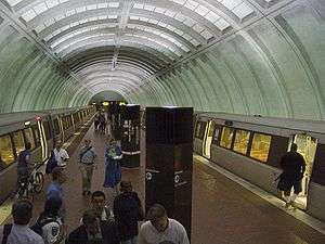
Station layout
| G | Street Level | Exit/ Entrance |
| M | Mezzanine | One-way faregates, ticket machines, station agent |
| P Platform level |
Westbound | ← |
| Island platform, doors will open on the left | ||
| Eastbound | → | |
References
- ↑ "Metrorail Average Weekday Passenger Boardings" (PDF). WMATA. Retrieved 2017-04-26.
- 1 2 Staff Reporters (August 25, 1984), "Red Line adds 6.8 miles; Opening ceremony for new segment set for today at Friendship Heights", The Washington Post, p. B1
- 1 2 Brisbane, Arthur S. (August 26, 1984), "All aboard; Metro festivities welcome latest Red Line extension", The Washington Post, p. A1
- ↑ Washington Metropolitan Area Transit Authority (July 2009). "Sequence of Metrorail openings" (PDF). Archived from the original (PDF) on January 13, 2010. Retrieved August 1, 2010.
- ↑ Ujifusa, Andrew (September 16, 2009). "County proposes underpass for Medical Center Metro station". Montgomery County Gazette. Retrieved December 10, 2010.
- ↑ http://www.wmata.com/about_metro/board_of_directors/board_docs/021413_MedicalCenterStationpackage2.pdf
- ↑ http://www.montgomerycountymd.gov/brac/projects/metro_mc.html
External links
![]() Media related to Medical Center (Washington Metro) at Wikimedia Commons
Media related to Medical Center (Washington Metro) at Wikimedia Commons
- WMATA: Medical Center Station
- StationMasters Online: Medical Center Station
- The Schumin Web Transit Center: Medical Center Station
- NIH Gateway Center construction map:
- South Drive entrance from Google Maps Street View