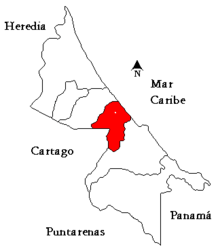
Matina (canton)
Coordinates: 10°04′43″N 083°17′32″W / 10.07861°N 83.29222°W

Matina canton in Limón province
Matina is the fifth canton in the province of Limón in Costa Rica. The canton covers an area of 576.48 km²,[1] and has a population of 37,549.[2] Its capital city is also called Matina.
The canton includes the Caribbean coast between the mouths of the Río Pacuare to the north and the Río Toro to the south. It lies between the Río Madre de Dios on the northwest side and the Río Toro on the east, and ranges as far south at the Río Boyei in the Cordillera de Talamanca.
Districts

Districts of Matina canton
The canton of Matina is subdivided into three districts (distritos):
- Matina, postal code 70501, coordinates 10°04′43″N 83°17′32″W / 10.07861°N 83.29222°W
- Villages (Poblados): Baltimore, Barra de Matina Norte, Bristol, Colonia Puriscaleña, Corina, Chirripó, Esperanza, Helvetia, Hilda, Línea B, Luisa Oeste, Milla 4, Milla 23, San Miguel, Victoria
- Batán (Bataan, Battan), postal code 70502, coordinates 10°05′09″N 83°20′32″W / 10.08583°N 83.34222°W
- Neighborhoods (Barrios): Milla 25
- Villages (Poblados): Barbilla, Berta, Damasco, Davao, Goshen, Leyte, Lola, Luzón, Margarita, Milla 24, Milla 27, Milla 28, Oracabesa, Parcelas, Sahara, Santa Marta, Titán, Vegas
- Carrandi, postal code 70503, coordinates 10°03′49″N 83°16′43″W / 10.06361°N 83.27861°W
- Villages (Poblados): Barra de Matina Sur, Boca del Pantano, Boca Río Matina, Boston, California, Indio, Larga Distancia, Luisa Este, Maravilla, Milla 14, Nueva York, Palacios, Peje, Punta de Riel, Río Cuba, Saborío, San Edmundo, San José, Sterling, Strafford, Toro, Trinidad, Venecia, Zent
History
The canton was established by law on June 24, 1969.
References
- ↑ Instituto Geográfico Nacional (IGN), 2001.
- ↑ Estimates of Instituto Nacional de Estadística y Censos (INEC), May 2003.
This article is issued from
Wikipedia.
The text is licensed under Creative Commons - Attribution - Sharealike.
Additional terms may apply for the media files.