Maryvale, Arizona
| Maryvale | |
|---|---|
| Urban Village of Phoenix | |
|
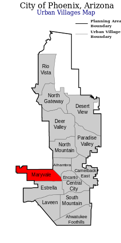
Maryvale Urban Village within Phoenix. | |
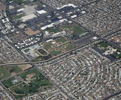
 Maryvale Baseball Park and surrounding suburban development. | |
| Coordinates: 33°30′07″N 112°10′40″W / 33.50194°N 112.17778°WCoordinates: 33°30′07″N 112°10′40″W / 33.50194°N 112.17778°W | |
| Country | United States |
| State | Arizona |
| City | Phoenix |
| Area[1] | |
| • Total | 32 sq mi (52 km2) |
| Elevation[2] | 1,119 ft (341 m) |
| Population (2010)[3] | |
| • Total | 208,189 |
| • Density | 6,500/sq mi (4,000/km2) |
| Area code(s) | 602 623 |
Maryvale (also referred to as West Phoenix) is a populated place and neighborhood of Phoenix, and was the first master planned community in Arizona. It is the predominant neighborhood of the near west side, from about 35th Avenue west to 87th Avenue and from I-10 north to the boundary with the suburb of Glendale at Camelback Road. It is the most populous of the 15 Urban Villages of Phoenix, being larger than the nearby suburbs of Goodyear and Avondale combined. [3]
History
Originally established during the 1950s and 1960s by developer John F. Long, it was the first master planned community in Arizona.[4] Maryvale's neighborhoods include inexpensive homes largely built during that time period.
Like many older inner-ring suburbs in the United States, Maryvale is suffering urban decline as the belt of expansion has passed by, increasing ever outward. Shopping in this area is provided by the Desert Sky Mall and Maryvale Mall, which are both suffering from lack of tenants. The Maryvale Mall now houses schools and a police station. Ashley Furniture HomeStore Pavilion, the city's most prominent outdoor concert venue, is located on the West Side. Because of the lower housing costs, Maryvale has attracted large numbers of families and immigrants from all over the world, particularly those from Mexico and other Latin American countries.
Since the 1980s, violent crime and gang activity have plagued the Maryvale community. Like other maligned areas of Phoenix, gangs took advantage of the area's open-air apartment complexes to set up enclosed drug markets that became extremely dangerous and difficult for police to monitor.[5] Focused efforts made by the Phoenix Police Department to reduce the crime rate in Maryvale—which had surpassed that of South Phoenix—have been successful. The crime rate has been significantly reduced to record levels. Phoenix police leaders and city officials have lauded the Maryvale Precinct's employment of concentrated community-based policing to thwart everything from property crimes to violent crimes. Liaison officers direct special details focused on robbery, auto theft, burglary, prostitution, drugs, and gang violence. In 2008, the violent-crime rate in Maryvale declined more than 5 percent, police say. Property crime decreased 9.5 percent in the area between Camelback and Baseline roads, from 27th Avenue to the western city limits. The shift in police philosophy included embedding Phoenix Gang Unit officers in the precinct, placing more sophisticated resources regularly in what one crime analysis described as "an area saturated with gang members."
The expanding west side of Phoenix continues to spread outward. Newer suburbs west of the city limits are springing up, including Avondale, Goodyear and Buckeye. Farther north, suburbs like Surprise, Peoria, El Mirage and the western end of Glendale are experiencing commercial and residential development.
Demographics
As of 2010, the Urban Village of Maryvale had a population of 208,189, living in an area of about 32 square miles (52 km²), giving a density of roughly 6,500/sq mi (4,000/km²).[1] While there are no racial majorities (≥50%), whites made up the largest single racial group, with 103,007 people (49.5% of the population). The second largest group was Black or African American, with 12,411 people (6%), followed by American Indian or Alaska Native, Asian, and Pacific Islander, with 3,955 (1.9%), 3,128 (1.5%), and 269 (0.1%), respectively. Other races made up 37% of the population (76,984 people), and people of two or more races made up 4.1% (8,435). 158,159 people (76%) were Hispanic or Latino of any race. The median age of the neighborhood was 25.87 in 2010. 36.7% of residents were minors, and 5.1% were retirement age (65 and older).[3]
As of 2010, there were 65,043 total housing units, with an occupancy rate of 85.5%. The average occupied household size was 3.74 people, and 52.6% of those housing units were owner-occupied. The median household value was about $136k, and the median rent was $947 per month. 64.15% of households made less than $50k per year, with 28.49% making less than $25k. 7.77% of households made over $100k. The median household income was $40,504/year.[3]
Notable residents
- Henry Cejudo, wrestler; won gold medal at 2008 Beijing Olympics
- Richard Jefferson, NBA player
- Doug Mathis, professional baseball pitcher[6]
- Sandra Day O'Connor, first female justice of the Supreme Court
- CeCe Peniston, R&B singer
- Phillippi Sparks, NFL player
- Darren Woodson, NFL player
References
- 1 2 "Phoenix Village Map" (PDF). Phoenix.gov. Retrieved 27 July 2015.
- ↑ "Feature Detail Report for: Maryvale". Geographic Names Information System. United States Geological Survey.
- 1 2 3 4 "Maryvale Census Data" (PDF). Phoenix.gov. Retrieved 27 July 2015.
- ↑ "John F. Long". The Arizona Republic. March 9, 2008. Retrieved December 1, 2016.
- ↑ http://www.phoenixnewtimes.com/1999-06-24/news/crackdown/
- ↑ "Doug Mathis". Baseball-Reference.com. Archived from the original on July 9, 2014. Retrieved December 24, 2016.
External links
- Phoenix Museum of History
- Official website of the State of Arizona
- Arizona State Library, Archives and Public Records
