Maryland Route 330
| ||||
|---|---|---|---|---|
| Massey Delaware Line Road | ||||
|
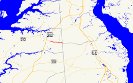
Maryland Route 330 highlighted in red | ||||
| Route information | ||||
| Maintained by MDSHA | ||||
| Length: | 3.72 mi[1] (5.99 km) | |||
| Existed: | 1988 – present | |||
| Major junctions | ||||
| West end: |
| |||
| East end: | Clayton Delaney Road at the Delaware state line near Massey | |||
| Location | ||||
| Counties: | Kent | |||
| Highway system | ||||
| ||||
Maryland Route 330 (MD 330) is a state highway in the U.S. state of Maryland. Known as Massey Delaware Line Road, the highway runs 3.72 miles (5.99 km) from MD 313 and MD 299 at Massey east to the Delaware state line in eastern Kent County, where the highway continues as Clayton Delaney Road. Massey Delaware Line Road was improved in 1954 but was not brought into the state highway system and designated MD 330 until the late 1980s.
Route description
MD 330 begins at a four-way intersection with MD 313 and MD 299 at Massey. MD 313 heads west (northbound) as Galena Massey Road and south as Millington Massey Road, and MD 299 heads north as Massey Road toward Sassafras. MD 330 heads east as a two-lane road that immediately has a grade crossing of the Centreville Branch of the Northern Line of the Maryland and Delaware Railroad just south of the junction of the Centreville and Chestertown branches of the Northern Line. The highway passes by the Massey Aerodrome and through Millington Wildlife Management Area. MD 330 crosses Black Bottom Branch before it reaches its eastern terminus at the Delaware state line, where the road continues east as Clayton Delaney Road in the southwest corner of New Castle County.[1][2]
History
The Maryland State Roads Commission reconstructed Massey Delaware Line Road as a gravel road from the railroad crossing to the state line in 1954; however, they decided to leave the highway in the county highway system.[3][4] The whole length of the highway was brought into the state highway system through a December 1, 1987, road transfer agreement.[5] The highway was designated MD 330 in July 1988.[6][7]
Junction list
The entire route is in Kent County.
| Location | mi[1] | km | Destinations | Notes | |
|---|---|---|---|---|---|
| Massey | 0.00 | 0.00 | Western terminus | ||
| | 3.72 | 5.99 | Clayton Delaney Road east | Eastern terminus; Delaware state line | |
| 1.000 mi = 1.609 km; 1.000 km = 0.621 mi | |||||
See also
 Maryland Roads portal
References
- 1 2 3 Highway Information Services Division (December 31, 2015). Highway Location Reference. Maryland State Highway Administration. Retrieved August 17, 2016.
- Kent County (PDF)
- ↑ Maryland State Highway Administration (2015). Maryland General Highway Statewide Grid Map (PDF) (Map). 1:12,000. Baltimore: Maryland State Highway Administration. §§ D16A. Retrieved August 17, 2016.
- ↑ McCain, Russell H.; Bennett, Edgar T.; Kelly, Bramwell (November 12, 1954). Report of the State Roads Commission of Maryland (1953–1954 ed.). Baltimore: Maryland State Roads Commission. p. 151. Retrieved August 17, 2016.
- ↑ "Excerpt from Minutes of Meeting of the State Roads Commission" (PDF). S.R.C. Minutes District No. 2 Kent County. Baltimore: Maryland State Roads Commission. February 3, 1955. Retrieved August 17, 2016 – via Maryland State Archives.
- ↑ "Memorandum of Action of Director Neil J. Pedersen" (PDF). S.R.C. Minutes District No. 2 Kent County. Baltimore: Maryland State Highway Administration. January 19, 1988. Retrieved August 17, 2016 – via Maryland State Archives.
- ↑ "Memorandum of Action of Director Neil J. Pedersen" (PDF). S.R.C. Minutes District No. 2 Kent County. Baltimore: Maryland State Highway Administration. July 11, 1988. Retrieved August 17, 2016 – via Maryland State Archives.
- ↑ Maryland State Highway Administration (1989). Maryland: Official Highway Map (Map). Baltimore: Maryland State Highway Administration.
External links
Route map: Google

